
Method for evaluating spatial information service quality and optimizing service chain

A technology for spatial information service and quality evaluation, applied in the field of spatial information service quality evaluation and service chain optimization, can solve the problems that the dynamic optimization of service chain is rarely involved, and achieve the goal of improving adaptability, ensuring smooth execution, and ensuring reliability. Effect

Inactive Publication Date: 2016-01-27
WUHAN UNIV
View PDF3 Cites 17 Cited by
  • Summary
  • Abstract
  • Description
  • Claims
  • Application Information

AI Technical Summary

Problems solved by technology

[0007] Existing service chain optimization schemes that consider QoS focus on the construction stage of the service chain, and seldom involve the dynamic optimization of the service chain during operation

Method used


Image

  • Method for evaluating spatial information service quality and optimizing service chain
  • Method for evaluating spatial information service quality and optimizing service chain
  • Method for evaluating spatial information service quality and optimizing service chain

Examples


Embodiment Construction

[0047] In order to facilitate those of ordinary skill in the art to understand and implement the present invention, the present invention will be described in further detail below in conjunction with the accompanying drawings and embodiments. It should be understood that the implementation examples described here are only used to illustrate and explain the present invention, and are not intended to limit this invention.

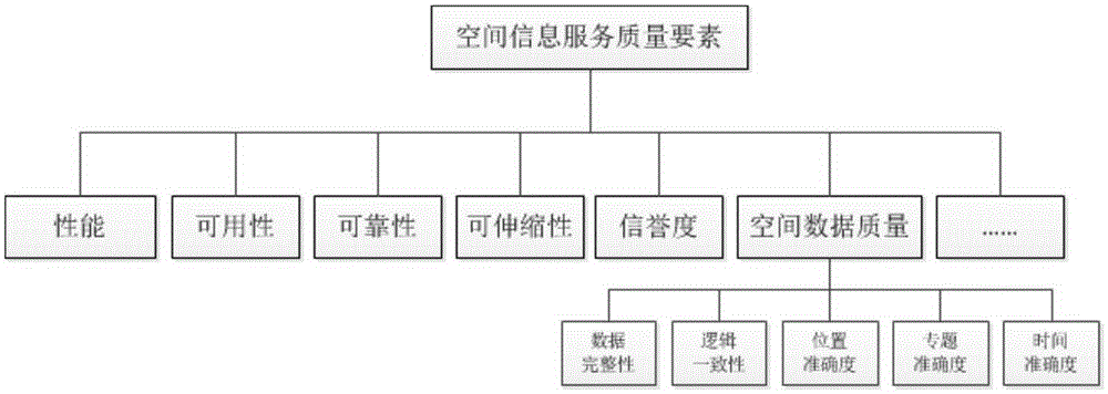
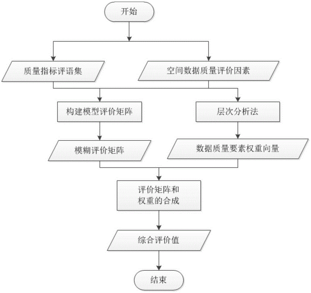
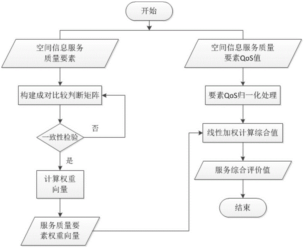
[0048] The invention introduces the spatial data quality into the evaluation of the spatial information service, comprehensively evaluates the spatial information service, and provides credible QoS references for users. A method for evaluating the quality of spatial information services provided by the present invention is to perform comprehensive evaluation of spatial information services through the element values ​​of spatial information services provided by a third-party service quality notarization platform; the specific evaluation steps are as follows: ...


PUM


Abstract

The invention discloses a method for evaluating spatial information service quality and optimizing a service chain. The method comprises the following steps: establishing a spatial information service element evaluation system at first, obtaining various element values through a service agent, and publishing finally quantified result data to a directory service centre. On the basis of directory service quality data, a spatial information service chain ensures that the whole QoS of the service chain is optimal through static optimization in a construction process and dynamic optimization in an operation process; the static optimization is as follows: an optimal service combination is searched by utilizing an optimization selection algorithm when local and global QoS constraint conditions are satisfied; and a specific server is bound to an abstract model; and the dynamic optimization is as follows: the service chain is dynamically monitored in the service chain operation process; the found QoS abnormal change condition is re-planed; and thus, smooth execution of the service chain is ensured. The method disclosed by the invention can assist users to find and select high-quality spatial information services from similar services so as to complete complex geographical processing tasks.

Description

technical field [0001] The invention belongs to the technical field of network geographic information system application, and in particular relates to a spatial information service quality evaluation and service chain optimization method. Background technique [0002] With the development and registration of a large number of spatial information services in the network environment, it is inevitable that there will be many spatial information services with the same function. For example, by following the standard spatial information processing service interface, different organizations can provide their own remote sensing image classification services , however the quality of these services varies. How to evaluate the quality of spatial information services and provide references for the selection of spatial information services is a scientific problem that needs to be solved urgently. [0003] In the field of general-purpose computers, many evaluation index systems have bee...

Claims


Application Information

Patent Timeline
Patent Type & Authority Applications(China)
IPC IPC(8): H04L12/24H04L29/08
CPCH04L41/145H04L43/55H04L67/61
Inventor 乐鹏谭振宇张明达
Owner WUHAN UNIV
Learn More