
Method for drawing airport label in synthetic vision system

A technology of synthetic vision and airport, which is applied in the field of aircraft navigation and positioning, can solve the problem of locating the destination airport, etc., and achieve the effect of reducing workload, probability and labor intensity

Active Publication Date: 2016-02-24
LUOYANG INST OF ELECTRO OPTICAL EQUIP OF AVIC
View PDF4 Cites 5 Cited by
  • Summary
  • Abstract
  • Description
  • Claims
  • Application Information

AI Technical Summary

Problems solved by technology

[0003] The purpose of the present invention is to overcome the deficiencies of the prior art, and proposes a method for drawing airport labels by the synthetic vision system, which solves the problem that pilots cannot directly locate the destination airport through the synthetic vision system

Method used


Image

  • Method for drawing airport label in synthetic vision system

Examples


Embodiment Construction

[0014] The present invention will be described in further detail below in conjunction with the accompanying drawings and embodiments.

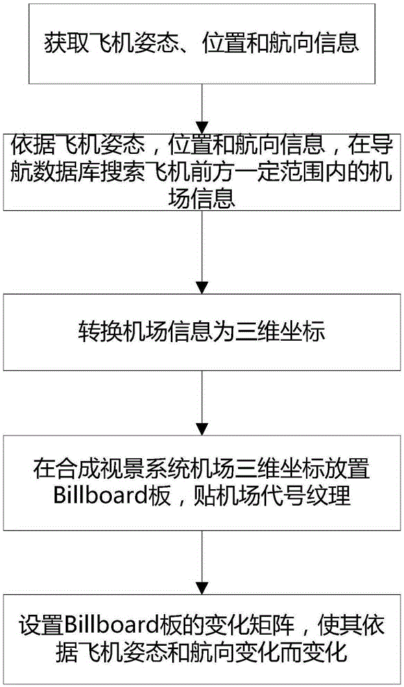
[0015] The present invention proposes a method for drawing an airport label by a synthetic visual system, and the specific steps of the method are as follows:

[0016] Step (1), obtain aircraft attitude, position and heading information from the aircraft's inertial reference system, GPS receiver and flight management computer respectively through the aircraft bus.

[0017] According to the obtained current attitude, position and heading information of the aircraft, the airport information within a certain range in front of the aircraft is retrieved through the navigation database, and transmitted to the synthetic vision system through the aircraft bus. The synthetic vision system belongs to the prior art. The system can provide the pilot with a view of the terrain outside the aircraft and improve the pilot's perception of the surrounding envir...


PUM


Abstract

The invention relates to a method for drawing an airport label in a synthetic vision system. The method comprises the following steps: acquiring a flying posture, position and heading of an aircraft according to a sensor on the aircraft, searching airport information in a set range of the aircraft, transmitting the information to the synthetic vision system on the aircraft, and converting the searched airport information to three-dimensional scene coordinates; arranging a Billboard on the airport three-dimensional scene coordinates to enable a normal vector of the Billboard to always point to the aircraft, and then sticking an airport label position draw onto the Billboard; when the aircraft changes the posture and the heading in real time, enabling the Billboard to always point to the aircraft by adjusting the normal vector of the Billboard to enable a pilot to clearly sense the position of the airport on the synthetic vision system. Through adoption of the method, the pilot can quick, accurately and clearly sense the airport label from the synthetic vision system, so that the possibility that the pilot misses a target airport or an alternate airport is lowered, and the pilot workload is reduced.

Description

technical field [0001] The invention relates to a method for drawing an airport label by a synthetic visual system, and belongs to the technical field of aircraft navigation and positioning. Background technique [0002] With the opening of my country's low-altitude airspace, there will be more and more private jets. As a result, the use of the airport is becoming more and more busy. If there is another bad weather, more aircraft will need to temporarily decide to land at the alternate airport. At this time, the pilot must clearly understand the airport conditions around the aircraft. At present, the synthetic vision system of the aircraft is mainly used to search the surrounding airports, but the synthetic vision system in the prior art only draws terrain information, and the pilot also needs to check the navigation information to determine the information of the destination airport and the alternate airport. This increases the pilot's workload, and it is easy to miss the ...

Claims


Application Information

Patent Timeline
Patent Type & Authority Applications(China)
IPC IPC(8): G01C21/22
CPCG01C21/22
Inventor 冯国昌范力维刘栋
Owner LUOYANG INST OF ELECTRO OPTICAL EQUIP OF AVIC
Learn More