Geographic information acquisition method and geographic information acquisition system

A technology of geographic information and acquisition method, applied in the field of geographic information acquisition method and geographic information acquisition system, can solve the problem of inability to obtain basic overview information, and achieve the effect of reducing travel burden and improving travel quality

Inactive Publication Date: 2016-03-02
SHENZHEN SEG SCI NAVIGATIONS CO LTD
View PDF5 Cites 20 Cited by
  • Summary
  • Abstract
  • Description
  • Claims
  • Application Information

AI Technical Summary

Problems solved by technology

However, through the above-mentioned positioning system, travelers can only obtain the current loca

Method used


Image

  • Geographic information acquisition method and geographic information acquisition system
  • Geographic information acquisition method and geographic information acquisition system
  • Geographic information acquisition method and geographic information acquisition system

Examples


Embodiment Construction

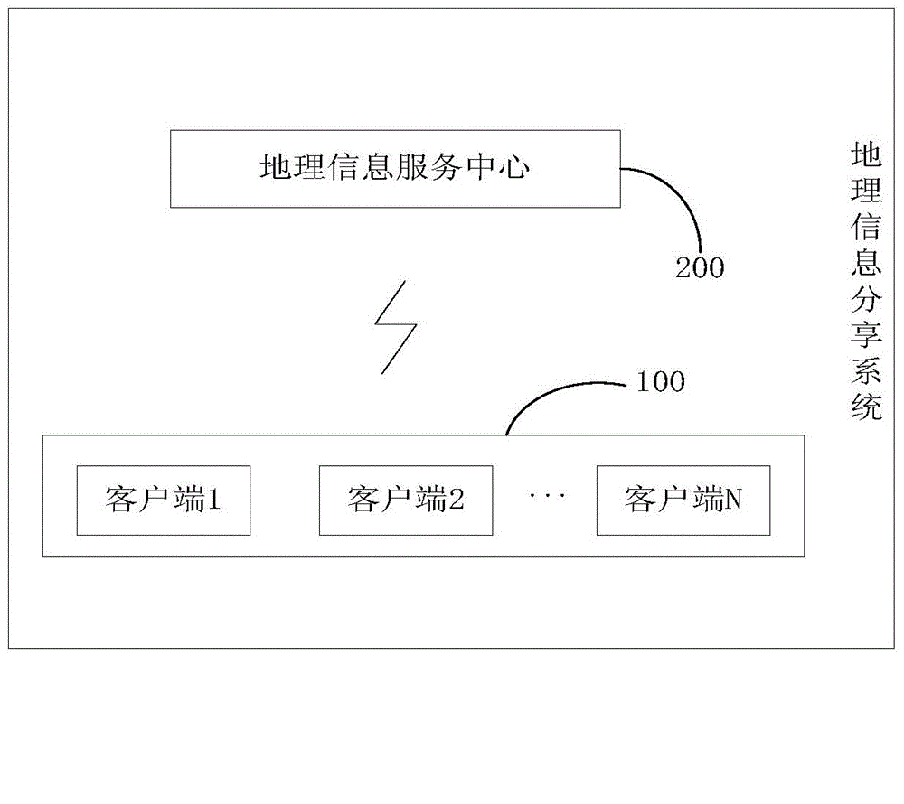
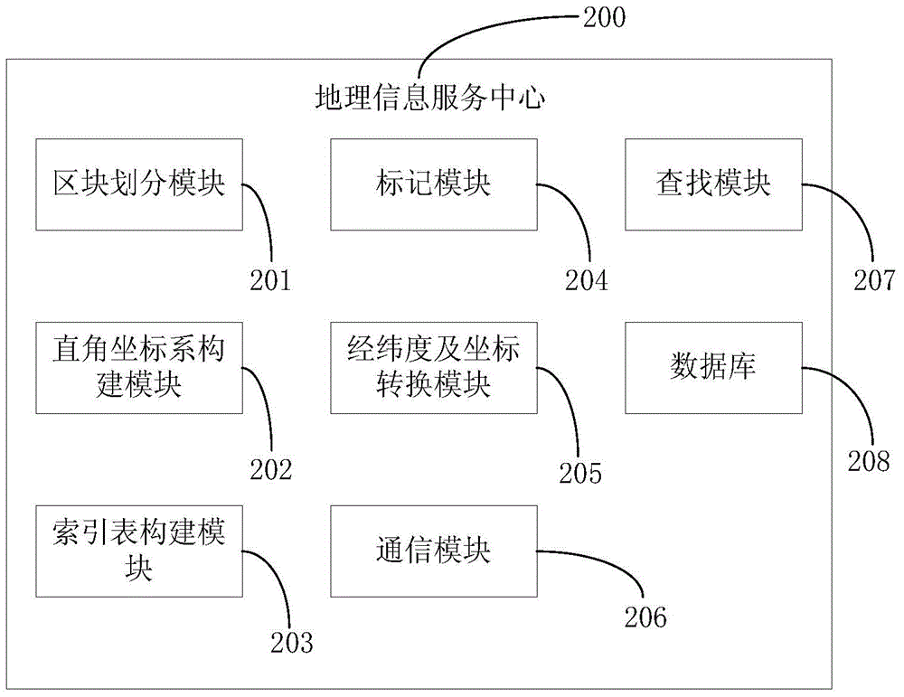
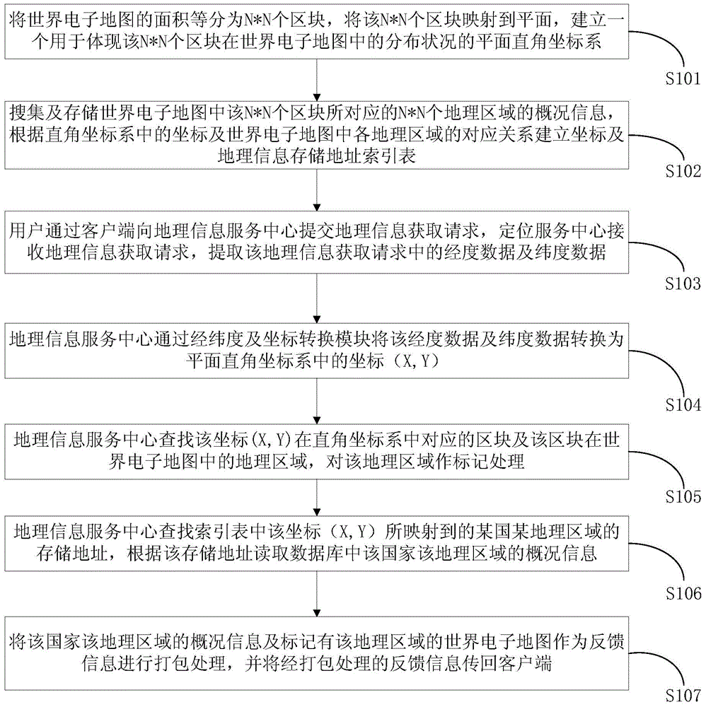
[0053]In order to solve the defect in the prior art that when tourists enter remote or inaccessible areas, it is difficult for tourists to know the basic information of the area by relying on the positioning system, which causes inconvenience to travel life, the main innovations of the present invention are: 1 ) through the cloud server to collect and store the geographical overview information of various regions around the world, to provide travelers with geographical overview query services in various countries and regions around the world; 2) in the present invention, the world electronic map is divided into N*N geographic regions block, the geographical information acquisition system of the present invention constructs a rectangular coordinate system according to the distribution of the above-mentioned N*N geographical blocks in the world electronic map, and constructs a grid coordinate and geographic information storage address index table based on the rectangular coordinat...


PUM


Abstract

The invention discloses a geographic information acquisition method and a geographic information acquisition system. The geographic information acquisition system comprises a plurality of client sides and a geographic information service center, wherein the geographic information service center comprises a geographic block subdivision module, a Cartesian mesh coordinate system construction module, a longitude and latitude and mesh coordinate conversion module and a search module; the geographic block subdivision module is used for equally dividing the area of an electronic world map into N*N geographic blocks; the Cartesian mesh coordinate system construction module is used for establishing a Cartesian coordinate system used for embodying the distribution situation of the N*N geographic blocks in the electronic world map; the longitude and latitude and mesh coordinate conversion module is used for converting longitude and latitude data in a received geographic information acquisition request into a mesh coordinate in the Cartesian coordinate system, and determining the geographic block corresponding to the mesh coordinate; and the search module is used for searching the general situation information of a geographic area corresponding to the geographic block and returning the general situation information of the geographic area to a client side.

Description

technical field [0001] The present invention relates to the technical field of positioning, and more specifically, to a geographic information acquisition method and a geographic information acquisition system. Background technique [0002] It is impractical for travelers to carry thick travel brochures with them during their travels. When travelers lose their sense of direction during travel, they often use GPS positioning devices or Beidou system positioning devices to obtain current location information and achieve preliminary positioning. However, through the above positioning system, the traveler can only obtain the current location information, but cannot know the basic general information of the area where he is located. Especially when travelers hike in inaccessible areas, travelers urgently need to know the basic general information of the area (including weather, temperature, vegetation and population distribution, road traffic information, and hospital location),...

Claims


Application Information

Patent Timeline
IPC IPC(8): G06F17/30
CPCG06F16/00
Inventor 王三旗刘超
Owner SHENZHEN SEG SCI NAVIGATIONS CO LTD
Why Eureka
Try Eureka