Self-propulsion type submarine topography and landform mapping system and method based on perception driving

A topographic and self-propelled technology, applied in surveying and navigation, surveying devices, cross-section depiction, etc., can solve the problem of low imaging resolution, complex working principle and equipment composition, and incomplete detection coverage area of ​​multi-beam surveying and mapping. problem, to achieve the effects of strong drawing performance, improved positioning performance, and improved calculation speed

Inactive Publication Date: 2016-03-09
OCEAN UNIV OF CHINA
View PDF3 Cites 14 Cited by
  • Summary
  • Abstract
  • Description
  • Claims
  • Application Information

AI Technical Summary

Problems solved by technology

[0003] (1) The echo detection method belongs to the point measurement method, that is, only the depth information of one point can be given at a time, and the work efficiency is very low
[0004] (2) The imaging resolution of the multi-beam surveying and mapping method is not high, its working principle and equipment composition are complex and requires external attitude sensor correction, thus

Method used


Image

  • Self-propulsion type submarine topography and landform mapping system and method based on perception driving
  • Self-propulsion type submarine topography and landform mapping system and method based on perception driving
  • Self-propulsion type submarine topography and landform mapping system and method based on perception driving

Examples


Embodiment Construction

[0032] The present invention will be further described below in conjunction with accompanying drawing.

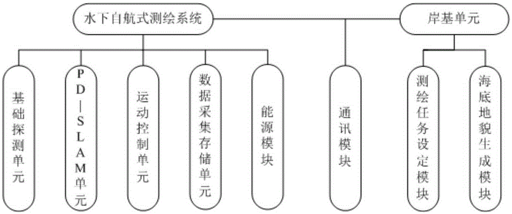
[0033] Such as figure 1 As shown, the system of the present invention includes an underwater self-propelled surveying and mapping system and a shore-based unit, and the two are connected by a communication module, wherein the underwater self-propelled surveying and mapping system includes a basic detection unit, a PD-SLAM unit, and a motion control unit. unit, data acquisition storage unit and energy module. The shore-based unit includes a surveying and mapping task setting module and a seabed topography generation module.

[0034] Among them, the PD-SLAM unit includes two parts: PDM module and SLAM module.

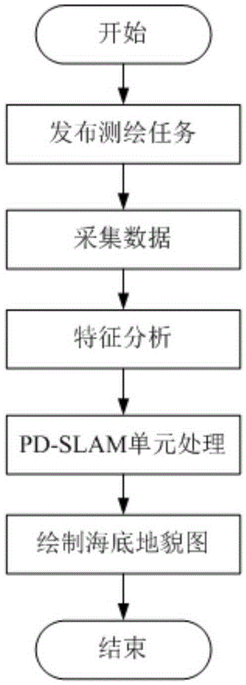
[0035] Such as figure 2 As shown, the system of the present invention specifically adopts the following methods to realize:

[0036] Step 1: The shore-based unit issues surveying and mapping tasks to the surveying and mapping system through the communication modul...


PUM


Abstract

The invention relates to a self-propulsion type submarine topography and landform mapping system and method based on perception driving and belongs to the technical field of mapping of submarine topographies and landforms, mainly aiming at solving the problems that a detection region covered by a detection track is not complete when mobile observation equipment executes a mapping task. The self-propulsion type submarine topography and landform mapping system comprises an underwater self-propulsion type mapping system and a shore-based unit, which are connected through a communication module. The working process comprises the following steps: issuing the mapping task; carrying out sonar data acquisition on the submarine landforms; carrying out characteristic analysis and extraction on acquired sonar data to obtain a pose point of the mobile observation equipment; processing the pose point by a PD-SLAM unit; and after scanning, outputting a submarine topography and landform graph. The self-propulsion type submarine topography and landform mapping system has the advantages that the working efficiency is high, a target region can be comprehensively measured, and fine characteristics of the underwater topographies and landforms can be accurately and rapidly mapped, so that self-propulsion type comprehensive measurement of the submarine topographies of the target region is really realized.

Description

technical field [0001] The invention relates to a self-propelled seabed topography surveying and mapping system and a surveying and mapping method based on perception drive, and belongs to the technical field of surveying and mapping of seabed topography and topography. Background technique [0002] Submarine topography and geomorphology surveying is closely related to the country's ocean development and production practices, and it also marks the development level of the country's ocean exploration technology. The traditional seabed topography surveying and mapping methods mainly include: echo sounding method, multi-beam surveying and mapping method, airborne lidar surveying and mapping method, etc. [0003] (1) The echo detection method belongs to the point measurement method, that is, it can only give the depth information of one point at a time, and the work efficiency is very low. [0004] (2) The imaging resolution of the multi-beam surveying and mapping method is not...

Claims


Application Information

Patent Timeline
IPC IPC(8): G01C7/00
CPCG01C7/00
Inventor 何波邵欣慧董兴帅年睿沈钺沙启鑫高强冯晨
Owner OCEAN UNIV OF CHINA
Why Eureka
Try Eureka