Normal incidence correcting method and system for satellite images

A satellite image and orthorectification technology, applied in the field of satellite image orthorectification methods and systems, can solve problems such as reducing data processing efficiency

Active Publication Date: 2016-03-09
CHINA AGRI UNIV
View PDF5 Cites 12 Cited by
  • Summary
  • Abstract
  • Description
  • Claims
  • Application Information

AI Technical Summary

Problems solved by technology

[0004] Although the RPC model orthotransform method in the prior art can meet the needs of practical applications in terms of correction accuracy, it needs repeated file reading and writing processes in the application process, and the intermediate file reading and writing process often consumes a certain amount of computing time. This undoubtedly reduces the efficiency of data processing, so it is of far-reaching significance to provide a fast orthorectification method for satellite images

Method used


Image

  • Normal incidence correcting method and system for satellite images
  • Normal incidence correcting method and system for satellite images
  • Normal incidence correcting method and system for satellite images

Examples


Embodiment Construction

[0056] Embodiments of the present invention will be described in detail below with reference to the accompanying drawings.

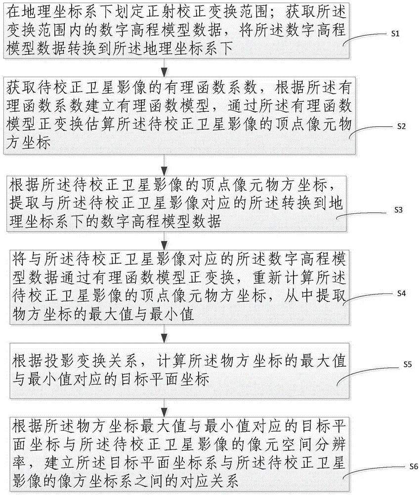
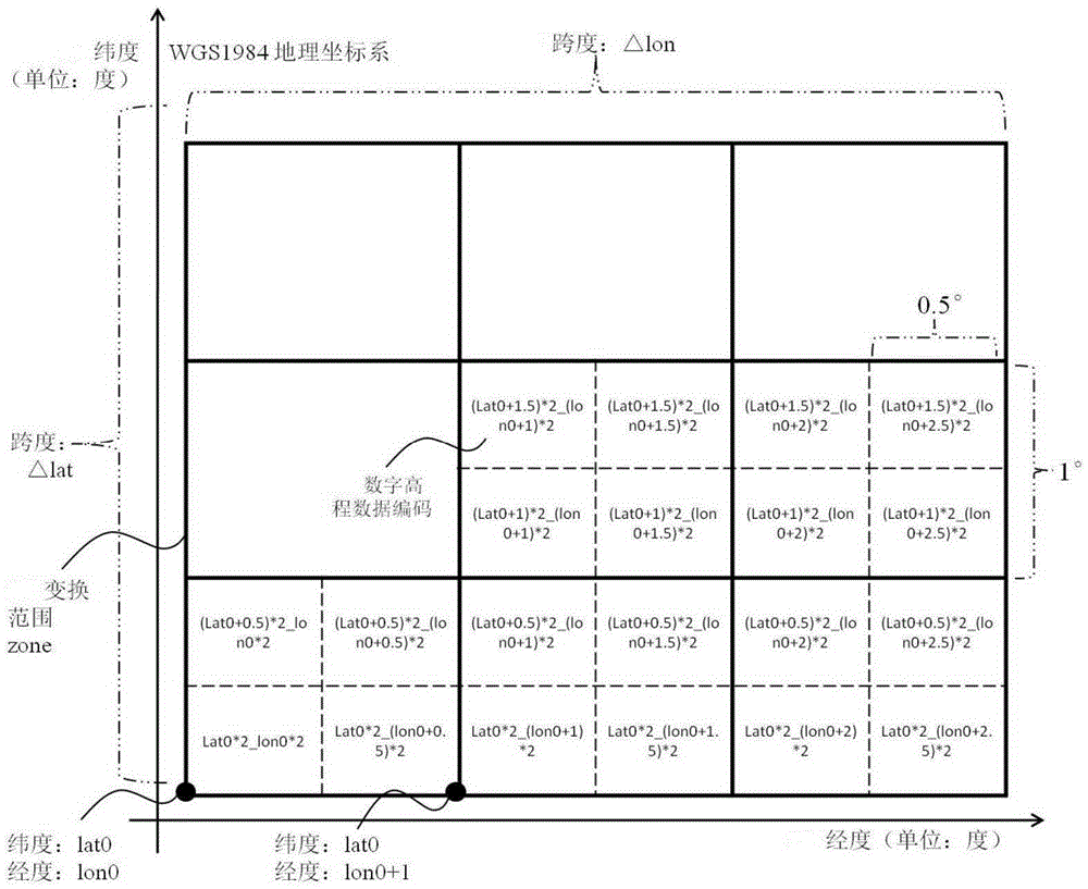
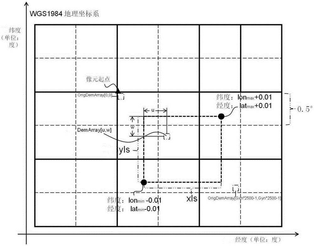
[0057] The present invention provides an orthorectification method that can be applied to satellite images on the Gaofen-1 satellite for the situation that the orthorectification result needs to be integrated with the space data under the plane coordinate reference, such as figure 1 As shown, the present invention includes the following steps: S1: Delineate the orthorectification transformation range under the geographic coordinate system; obtain digital elevation model data within the transformation range, and convert the digital elevation model data to the geographic coordinate system Down;

[0058] S2: Obtain the rational function coefficients of the satellite images to be corrected, establish a rational function model according to the rational function coefficients, and estimate the object space coordinates of the vertex pixels of the satellite image...


PUM


Abstract

The invention relates to a normal incidence correcting method for satellite images. The normal incidence correcting method comprises the steps that a normal incidence correcting transformation range is delimited; DEM data in the transformation range are obtained and converted under a geographic coordinate system; RPC coefficients of the satellite images to be corrected are obtained, and peak pixel object space coordinates of the images are estimated through an RPC model; DEM data corresponding to the images are extracted; the DEM data are used for recalculating the peak pixel object space coordinates through the RPC model; a projection transformation relation between a geographic coordinate system and a target plane coordinate system is established; a corresponding relation between the target plane coordinate system and the image space coordinate system of the satellite images to be corrected is established. By means of the normal incidence correcting method for the satellite images, middle reading and writing can be reduced, the calculation speed of normal incidence correcting can be increased, the pressure of a hardware storage space can be reduced, hardware losses can be reduced, the change of a calculation area range can be met, the engineering application requirement can be met, and normal incidence corrected products of the satellite images under the plane coordinate reference can be output.

Description

technical field [0001] The invention relates to the technical field of image processing, in particular to a satellite image orthorectification method and system. Background technique [0002] The Gaofen-1 satellite (referred to as GF-1 satellite) was launched in April 2013 at the Jiuquan Satellite Launch Center. The satellite operates in a sun-synchronous return orbit with an orbital altitude of 645km. It is equipped with two 2-meter-resolution panchromatic / 8-meter-resolution multispectral cameras (referred to as PMS, with a combined width of 60km), and four 16-meter-resolution multispectral cameras (referred to as WFV, the combined width is 800km), and the WFV image achieves a four-day coverage period. Among them, the GF-1LV1A image product has detailed radiation calibration coefficients, spectral response parameters, and rational polynomial coefficients. With its good temporal and spatial resolution characteristics, it has broad application prospects in the fields of agri...

Claims


Application Information

Patent Timeline
Patent Type & Authority Applications(China)
IPC IPC(8): G01C11/00G06T3/00G06T5/00B64G1/10
CPCB64G1/1021G01C11/00G06T3/0068G06T5/006G06T2207/10032G06T2207/30232
Inventor 朱德海叶思菁岳彦利刘帝佑杜振博李林熊全姚晓闯李鹏山
Owner CHINA AGRI UNIV
Why Eureka
Try Eureka