Accurate positioning method of planar target for ground laser scanning data registration

A ground laser scanning and planar target technology, which is applied in the field of precise positioning of planar rotationally symmetrical targets, can solve the problem of high cost of using target balls and reflectors, achieve robust identification and positioning of targets, and achieve excellent results in data registration accuracy

Inactive Publication Date: 2016-03-23
TIANJIN NORMAL UNIVERSITY
View PDF6 Cites 10 Cited by
  • Summary
  • Abstract
  • Description
  • Claims
  • Application Information

AI Technical Summary

Problems solved by technology

Usually, the cost of using target balls and reflectors is high

Method used


Image

  • Accurate positioning method of planar target for ground laser scanning data registration
  • Accurate positioning method of planar target for ground laser scanning data registration
  • Accurate positioning method of planar target for ground laser scanning data registration

Examples


Embodiment 1

[0034] Step 1. Interactively select the point cloud data near the bullseye of the target, and use the principal component analysis method to determine the plane where the point cloud data is located. The following covariance matrix is ​​constructed by using the three-dimensional coordinates of the laser scanning point cloud data near the bullseye:

[0035]

[0036] in, Perform principal component analysis on the matrix, and the plane where the target point cloud data is located is approximately expressed by the eigenvectors corresponding to the two largest eigenvalues;

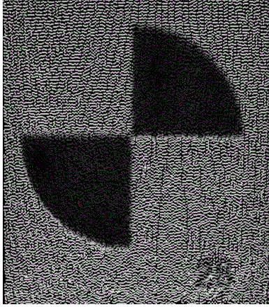
[0037] The planar target that the present invention is aimed at is as figure 1 shown. The target pattern is a black and white pattern, and the pattern is rotationally symmetrical. Before laser scanning, the figure 1 The targets shown are printed out as multiple paper targets spread out as evenly as possible on the scan scene. The laser scanning point cloud usually records the three-dimensional coordin...


PUM


Abstract

The invention relates to accurate positioning of a planar target for ground laser scanning data registration, comprising the following steps: first, using the principal component analysis algorithm to determine a plane where point cloud data is located based on the point cloud data near the bull's eye of an artificial target; second, orthographically projecting the point cloud data to generate an orthographic projection intensity image of the point cloud data; third, in the generated orthographic projection intensity image, determining the position of the bull's eye in the intensity image based on a rotational symmetry pattern recognition and positioning algorithm; and fourth, determining the three-dimensional coordinates of the bull's eye according to the corresponding relationship between laser scanning points and the pixels of the projected image. When there is no laser scanning point corresponding to the bull's eye positioned in the intensity image, the three-dimensional coordinates of the bull's eye are estimated through a nonlinear least squares method. The technical scheme put forward by the invention is of great significance and practical value to ground laser scanning data processing and three-dimensional modeling. By applying the method put forward by the invention to ground laser scanning point cloud data registration, the registration precision can reach the millimeter level.

Description

[0001] This invention is funded by Tianjin Normal University doctoral fund project, project number: 52XB1306. technical field [0002] The invention belongs to the technical field of surveying and mapping and reverse engineering, and relates to the precise positioning of a plane rotationally symmetrical target in the process of precise registration of multi-station scanning data when ground laser scanning technology is used for precise three-dimensional measurement of a target surface. Background technique [0003] Terrestrial laser scanning technology can be used to quickly obtain high-precision, high-density 3D measurement data of the environment in which the scanner is located. In recent years, terrestrial laser scanning technology has been widely used in the fields of urban 3D modeling, engineering survey, historical building protection and archaeology. Due to the existence of occlusion, single-station terrestrial laser scanning can only obtain part of the surface data o...

Claims


Application Information

Patent Timeline
Patent Type & Authority Applications(China)
IPC IPC(8): G01B11/00
CPCG01B11/002
Inventor 梁玉斌
Owner TIANJIN NORMAL UNIVERSITY
Why Eureka
Try Eureka