Road data reduction and storage method suitable for real-time road condition broadcast

A technology of road data and real-time road conditions, applied in the directions of road network navigators, electrical digital data processing, geographic information databases, etc., can solve problems such as difficulty in meeting road conditions broadcast, etc., and achieve the effect of facilitating speech understanding and simplifying road data.

Inactive Publication Date: 2016-04-06
XIAMEN YAXON NETWORKS CO LTD
View PDF7 Cites 8 Cited by
  • Summary
  • Abstract
  • Description
  • Claims
  • Application Information

AI Technical Summary

Problems solved by technology

With such a storage structure, it will be difficul...

Method used


Image

  • Road data reduction and storage method suitable for real-time road condition broadcast
  • Road data reduction and storage method suitable for real-time road condition broadcast
  • Road data reduction and storage method suitable for real-time road condition broadcast

Examples


Embodiment Construction

[0028] The present invention will be further described in conjunction with the accompanying drawings and specific embodiments.

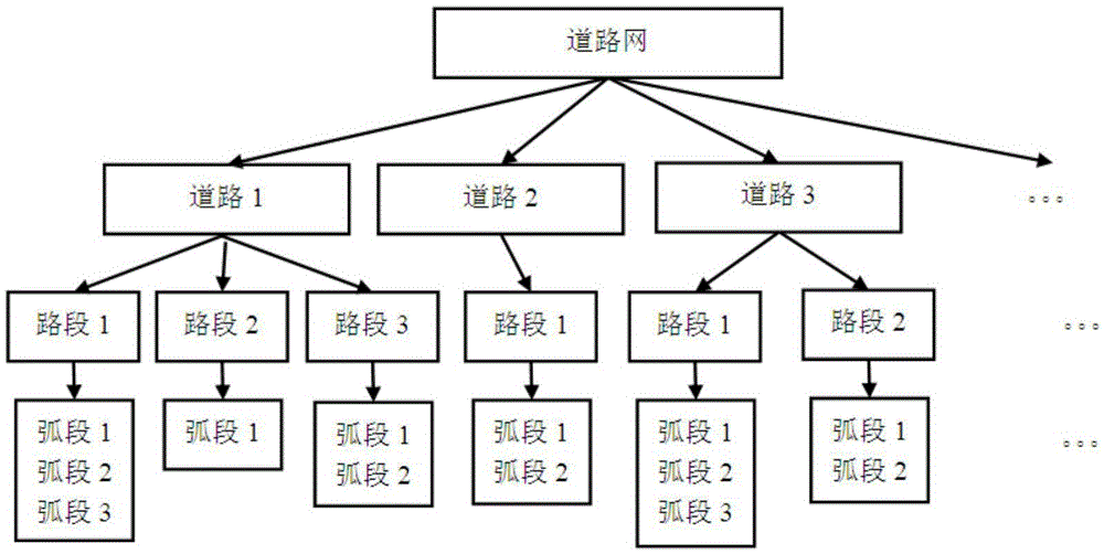
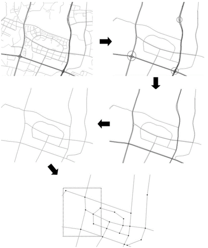
[0029] As a specific example, such as Figure 1 to Figure 3 As shown, a kind of road data simplification and storage method applicable to real-time road condition broadcasting of the present invention comprises the following steps:

[0030] (1) Process the original navigation electronic map road data

[0031] ① Select roads by grade and name

[0032] Because the road data in the navigation electronic map includes all grades of roads including roads without names and low grades that are not open to traffic. Therefore, it is necessary to select a road section with a higher grade and a road name with a certain grade standard (such as grade 5).

[0033] ② In the selection result, select the road again according to the shape and characteristics of the road

[0034] After selection, there are auxiliary roads, left (right) turning lanes, U-turn lanes, a...


PUM


Abstract

The invention relates to the technical field of geographic position data processing, in particular to a road data reduction and storage method suitable for real-time road condition broadcast. The method comprises the following steps: (1) processing original navigation electronic map road data, that is, screening roads according to road grade names, screening roads according to the road forms and characteristics, enabling two-line roads to be single-line roads, recombining and carrying out road node compression; (2) building a three-layer road system structure according to the information of roads with the same names; (3) storing the processed road data in a geoJSON format document structure according to the road stratification system, wherein the geoJSON format document structure is applied to voice broadcast of road conditions and drawing of a simple road condition diagram. According to the invention, the road data in the navigation electronic map is simplified, redundant information is eliminated, and the road storage structure suitable for road condition broadcast is designed.

Description

technical field [0001] The invention relates to the technical field of geographical location data processing, in particular to a road data simplification and storage method suitable for real-time road condition broadcasting. Background technique [0002] The road background data based on the traditional road condition service is usually navigation electronic map data. In navigation electronic maps, roads are usually stored in an arc node model, which can capture all real details in the real world, such as road curves (spatial details) or lanes (attribute details). This road storage method can visualize the road condition information on the navigation map in more detail, but when using the voice broadcast method for real-time traffic broadcast service, it is necessary to use a highly abstract and concise description to let users understand what they need to know traffic information. The traditional way of storing road navigation data has a lot of redundant information, whic...

Claims


Application Information

Patent Timeline
IPC IPC(8): G01C21/32G06F17/30
CPCG01C21/32G06F16/29
Inventor 周贺杰季刚王国清崔跃
Owner XIAMEN YAXON NETWORKS CO LTD
Why Eureka
Try Eureka