Dynamic precise single-point positioning method for bathymetric survey without tidal observation

A precise single-point positioning and dynamic technology, which is used in the measurement of the depth of open-air water sources, measuring devices, and open-air water source surveys, etc. It can solve the problems of long convergence time, distance limitation of differential positioning technology, and high operating costs

Inactive Publication Date: 2016-04-13
长江南京航道局
View PDF3 Cites 15 Cited by
  • Summary
  • Abstract
  • Description
  • Claims
  • Application Information

AI Technical Summary

Problems solved by technology

[0004] In order to overcome the deficiencies of the prior art, the purpose of the present invention is to disclose a new method of dynamic and precise single point positioning with water level constraints, which can be better applied to the water depth m

Method used


Image

  • Dynamic precise single-point positioning method for bathymetric survey without tidal observation
  • Dynamic precise single-point positioning method for bathymetric survey without tidal observation
  • Dynamic precise single-point positioning method for bathymetric survey without tidal observation

Examples


Embodiment Construction

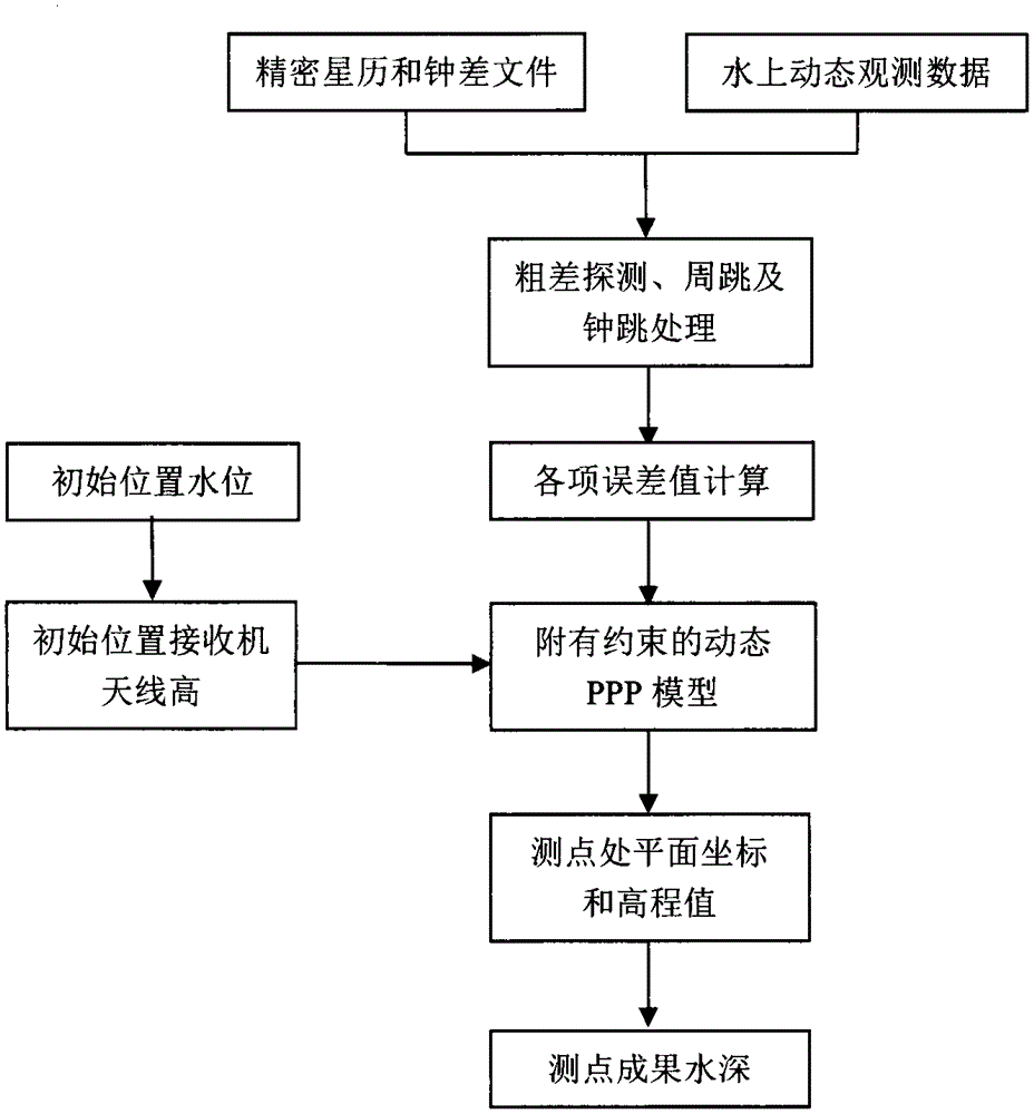
[0041] The technical solution of the present invention will be described in further detail below in conjunction with the accompanying drawings and specific embodiments:

[0042] Such as figure 1 A flowchart of the method is shown. Next, the Hi-Target V30 receiver and HD-310 depth sounder are used to collect dynamic GPS / GLONASS dual-system, dual-frequency pseudo-range and carrier observation data on the Nanjing section of the Yangtze River. The sampling rate is 1s, and the satellite cut-off elevation angle is 10°. The new method proposed by the invention is used for dynamic calculation, and the final positioning result is compared with the traditional precision single point positioning result and the water level of the tide gauge station.

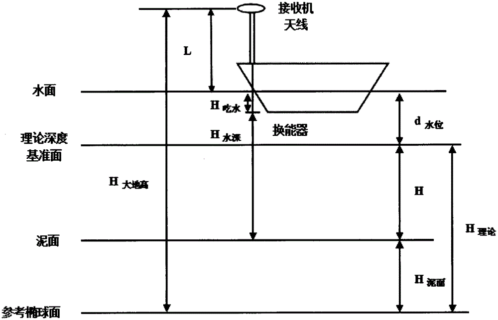
[0043] Firstly, download the precise ephemeris and precise clock error products for the required time period from the IGS website, combine the recorded original observation data and initial water level value, and use the self-written dynami...


PUM


Abstract

The invention discloses a dynamic precise single-point positioning method for a bathymetric survey without tidal observation, which belongs to the field of dynamic precise single-point positioning. The method is based on dynamic precise single-point positioning technology with water level constraints, projects out the elevation of a receiver antenna from the water level value of a test beginning position, introduces elevation constraining conditions into an observation equation according to the characteristic that the water level of an inland waterway does not change significantly and acquires planar and elevation information of each measuring point by using a dynamic precise single-point positioning model with elevation constraints, thereby realizing calculation of the water level value of each measuring point. The dynamic precise single-point positioning method for the bathymetric survey without tidal observation can accelerate dynamic precise single-point positioning convergence time and improve work efficiency.

Description

technical field [0001] The invention relates to the field of dynamic precise single-point positioning, in particular to the application of precise single-point positioning technology in water depth measurement without tide gauge, which accelerates the convergence speed of dynamic precise single-point positioning. technical background [0002] Satellite positioning technology has achieved relatively long-term development in the field of marine surveying and mapping. The combination of satellite positioning technology and bathymetry can realize automatic high-precision channel bathymetry. The basic principle of non-tide bathymetry is to use high-precision satellite positioning technology to obtain the elevation of the antenna center, obtain the elevation in the required coordinate system through elevation conversion, and finally calculate the relative depth reference of the underwater mud surface according to the depth sounder data and other information elevation of the face. ...

Claims


Application Information

Patent Timeline
IPC IPC(8): G01C13/00
CPCG01C13/008Y02A90/30
Inventor 顾网林徐峰李术元李昱周庆雷肖祖惠方向夏辉宇翟信德潘晓峰刘芳高成发何帆时小飞
Owner 长江南京航道局
Why Eureka
Try Eureka