
Inter-cloud GIS service deploying system in Linux environment

A technology for deploying systems and environments, applied in the field of GIS services, can solve problems such as update management difficulties, downtime related losses, etc., and achieve the effect of ensuring scalability and versatility

Active Publication Date: 2016-04-13
吉奥时空信息技术股份有限公司
View PDF3 Cites 29 Cited by
  • Summary
  • Abstract
  • Description
  • Claims
  • Application Information

AI Technical Summary

Problems solved by technology

[0010] Another purpose of the present invention is to solve the update management difficulties existing in the prior art, which easily bring technical problems such as a large number of downtime related losses, and provide a cloud-based GIS service deployment system under the Linux environment

Method used


Image

  • Inter-cloud GIS service deploying system in Linux environment
  • Inter-cloud GIS service deploying system in Linux environment
  • Inter-cloud GIS service deploying system in Linux environment

Examples


Embodiment

[0054] This embodiment involves multiple key links and workflows of the entire cloud platform. First, let's take a look at the important technical procedures of the technical solution of the present invention. In the traditional mode, the scenario of deploying GIS services in an infrastructure cloud environment can be roughly summarized as follows figure 1 shown.

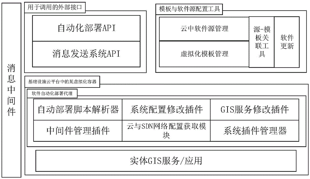
[0055] figure 2 It is the process of deploying GIS service scenarios in the infrastructure cloud environment after adopting the solution of the present invention; under the scheme system, this process becomes simpler and more intelligent. What kind of technical means is used to achieve this, let's take a look at the specific implementation architecture below. On the whole, the structure of this program is as follows: image 3 shown, including:

[0056] A virtualized container device placed in the infrastructure cloud platform for deploying GIS software in the cloud environment and modifying service-related para...


PUM


Abstract

The invention relates to a deploying system of inter-cloud GIS service belonging to the GIS service field, specifically relating to an inter-cloud GIS service deploying system in a Linux environment. According to the invention, a cross-cloud platform technical method is utilized; a complete set of automatic deploying mode is constructed on the premise of not relating to the cloud platform capability of any base installation; a mode of automatically detecting a cloud template and GIS service software itself is provided; a complete set of mode of automatically deploying and automatically / manually updating the GIS service in the cloud by the GIS service software is realized according to the mode through invoking a Java API. The automatic deploying agent in the virtual container of the invention depends on an OS and does not depend on any cloud platform or virtual container; the agent analyzes corresponding operation according to the request sent to a message midware from an upper layer API and completely realizes a set of updating mode of matching related software in the cloud by the GIS service.

Description

technical field [0001] The invention relates to a deployment system for GIS services in the cloud, which belongs to the field of GIS services, and in particular to a deployment system for GIS services in the cloud under the Linux environment. Background technique [0002] With the development of computer technology and the continuous improvement of GIS application level, new changes have taken place in GIS software technology. Among them, SaaS, which is closely related to GIS, is software as a service. After taking advantage of the characteristics of SaaS, GIS software and services can directly provide software services through the Internet or private networks. GIS software providers deploy the application software on their own servers, and GIS customers can order the required Web application software services from the cloud through the portal website or the operation and maintenance center according to their actual needs. SaaS enables GIS users to use various software and...

Claims


Application Information

Patent Timeline
Patent Type & Authority Applications(China)
IPC IPC(8): G06F9/445G06F9/455
CPCG06F8/61G06F8/656G06F9/44505G06F9/45533
Inventor 杨曦梁俊雄廖磊贾宏朱斌张龙官磊
Owner 吉奥时空信息技术股份有限公司
Learn More