Shallow sea water depth multi-source remote sensing fusion inversion method

A sounding inversion and bathymetry technology, applied in the field of space remote sensing, can solve the problems of remote sensing image spectral data band, limited use range of spectral information, poor bathymetric accuracy and accuracy, etc.

Inactive Publication Date: 2016-06-08
THE FIRST INST OF OCEANOGRAPHY SOA
View PDF3 Cites 19 Cited by
  • Summary
  • Abstract
  • Description
  • Claims
  • Application Information

AI Technical Summary

Problems solved by technology

[0006] The present invention provides a shallow water depth multi-source remote sensing fusion inversion method based on decision-making fusion, which is used to solve the problem of using only the image of a single-source remote sensor as a data source in the prior art, and the use of spectral data bands and spectral information of remote sensing images Limited range, poor accuracy and accuracy of bathymetry

Method used


Image

  • Shallow sea water depth multi-source remote sensing fusion inversion method
  • Shallow sea water depth multi-source remote sensing fusion inversion method
  • Shallow sea water depth multi-source remote sensing fusion inversion method

Examples


Embodiment Construction

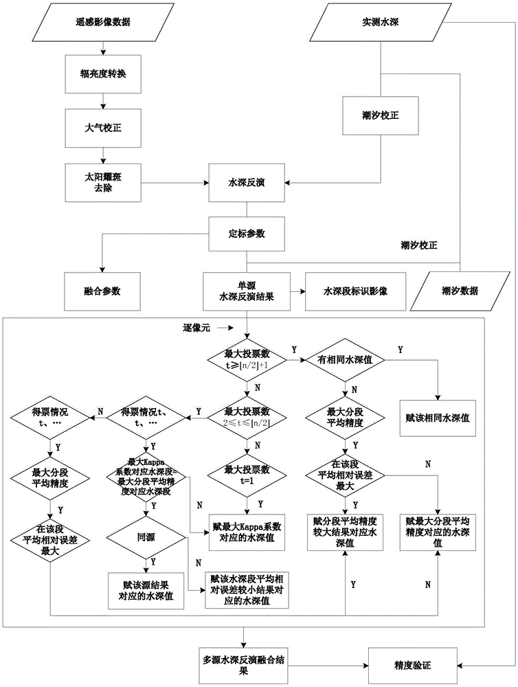
[0042] In order to make the purpose, technical solutions and advantages of the embodiments of the present invention more clear, the technical solutions in the embodiments of the present invention will be clearly and completely described below in conjunction with the drawings in the embodiments of the present invention.

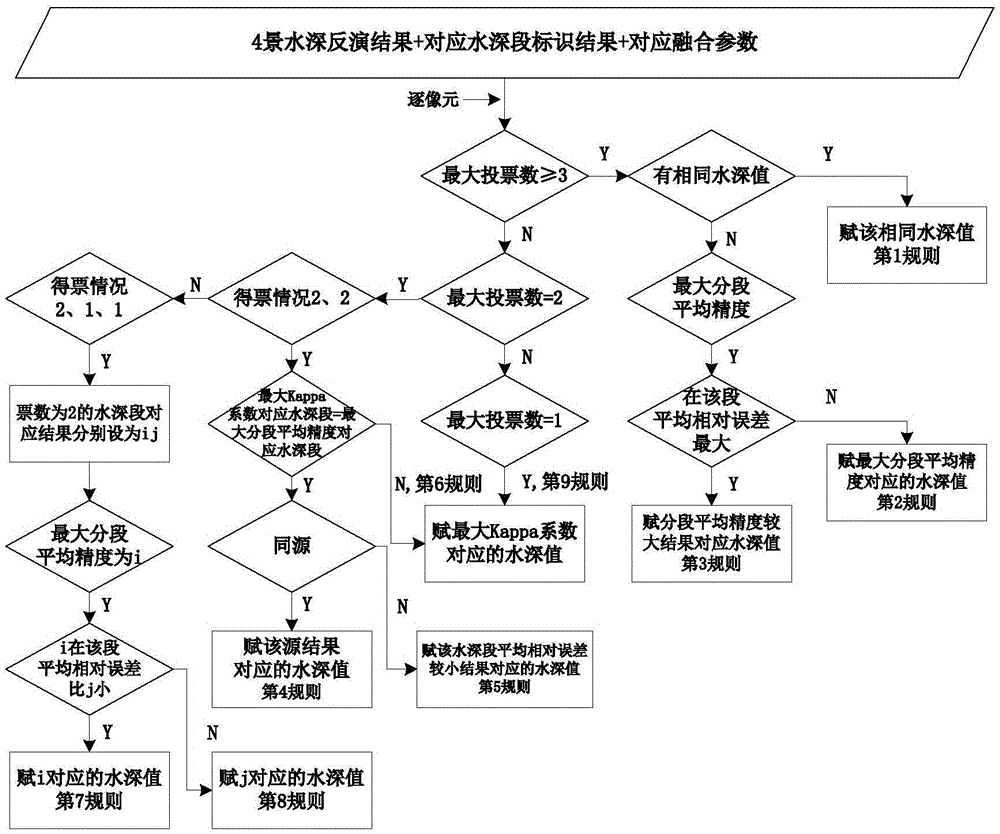
[0043] combined with figure 1 To further describe the specific implementation of the present invention in detail, the shallow water depth multi-source remote sensing fusion inversion method specifically includes the following steps:

[0044] Step 1: Multispectral remote sensing data preprocessing:

[0045] Firstly, the multi-spectral remote sensing images obtained through multi-source sensors and involved in the fusion of water depth inversion should be preprocessed, including radiance conversion, atmospheric correction and solar flare removal. Radiance conversion is the process of converting image DN values ​​into radiance. Different remote sensing data produc...


PUM


Abstract

A shallow sea water depth multi-source remote sensing fusion inversion method comprises the steps of: 1, preprocessing a multispectral remote sensing image to obtain a sea surface reflectivity; 2, acquiring and processing a field test depth value; 3, conducting single-source water depth inversion and water depth segment identification; 4, conducting multi-source water depth inversion fusion; and 5, conducting water depth inversion accuracy verification; using the n types of single-source water depth results, corresponding water depth segment identification images and fusion parameters as input, and conducting multi-source water depth inversion fusion by pixel; verifying water depth inversion accuracy, and using a final depth value as the output data of the actual water depth value of the remote sensing image. Compared with the inversion method of the prior art, the method can comprehensively utilize different responses of a plurality of remote sensing data sources to water depth information, excavate the water depth data, improve inversion accuracy, and conduct decision-making fusion process, and is especially applicable to marine water depth measurement of shallow water region in complex situations.

Description

technical field [0001] The invention relates to a method for measuring ocean water depth, which belongs to the technical field of space remote sensing, and in particular relates to a shallow water depth multi-source remote sensing fusion inversion method that can use multiple remote sensors to detect ocean water depth. Background technique [0002] Ocean bathymetry is the necessary basic data to ensure ship navigation, carry out port wharf and marine engineering construction, and formulate relevant plans for coasts and islands. Compared with on-site water depth measurement methods, remote sensing technology has many advantages such as wide coverage, short cycle, low cost, and high spatial resolution. Since the 1970s, research on various passive remote sensing water depth inversion models has been carried out at home and abroad. Commonly used visible light water depth inversion models mainly include analytical models, semi-analytical and semi-empirical models, and statistical...

Claims


Application Information

Patent Timeline
Patent Type & Authority Applications(China)
IPC IPC(8): G01C13/00
CPCG01C13/008
Inventor 张靖宇马毅张震梁建
Owner THE FIRST INST OF OCEANOGRAPHY SOA
Why Eureka
Try Eureka