Lane judgment method based on latitude and longitude acquisition points and positioning device thereof

A judging method and technology of longitude and latitude, applied in traffic control systems of road vehicles, traffic flow detection, instruments, etc., can solve the problems of large positioning deviation of GPS positioning, affecting the normal operation of radar, and low reliability of data, so as to achieve safety The effect of high precision, high reliability and fast data feedback

Active Publication Date: 2016-06-22
JIANGSU LIANMENG INFORMATION ENG CO LTD
View PDF6 Cites 21 Cited by
  • Summary
  • Abstract
  • Description
  • Claims
  • Application Information

AI Technical Summary

Problems solved by technology

[0005] For radar measurement, it mainly uses radar to perform wide-range ranging, so as to provide drivers with a certain driving reference, but it is limited by road conditions, and some guardrails and other objects on the driveway can easily affect the normal

Method used


Image

  • Lane judgment method based on latitude and longitude acquisition points and positioning device thereof
  • Lane judgment method based on latitude and longitude acquisition points and positioning device thereof

Examples


Embodiment Construction

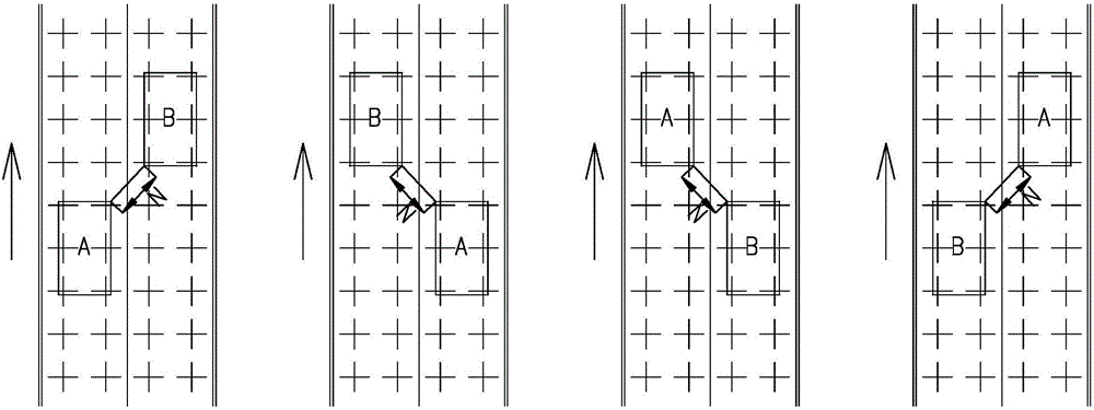
[0029] Below in conjunction with accompanying drawing and specific embodiment, further illustrate the present invention, should be understood that these embodiments are only for illustrating the present invention and are not intended to limit the scope of the present invention, after having read the present invention, those skilled in the art will understand various aspects of the present invention Modifications in equivalent forms all fall within the scope defined by the appended claims of this application.

[0030] A lane determination method based on latitude and longitude collection points, specifically comprising the following steps:

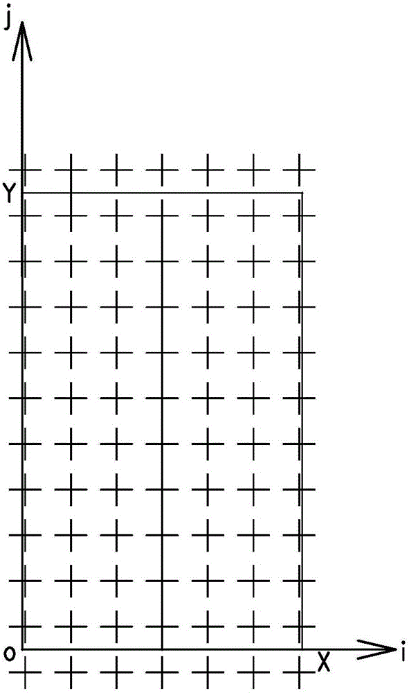
[0031] Step 1: Set some reference points for the target road, figure 1 Indicated by "+", the coordinate values ​​of the reference point are marked by longitude and latitude, and the main coordinate matrix of the target road is obtained.

[0032] Step 2: Partition the reference points in different lanes on the target road to obtain the sub-...


PUM


Abstract

The invention discloses a lane judgment method based on latitude and longitude acquisition points. Multiple reference points are set on a target road, and a principal coordinate matrix of the target rod and a sub-coordinate matrix of each lane are acquired; the lane in which a target vehicle is positioned is determined, the coordinate values of all the reference vehicles in the adjacent lanes of the lane in which the target vehicle is positioned are collected, and actual distance between the target vehicle and the reference vehicles is acquired through matrix calculation; and whether the target vehicle can change lane is judged by comparing the actual distance and safe distance. Meanwhile, the invention also discloses a positioning device applied to the method. Advantages of the method are that the method has higher reliability in comparison with that of an independent GPS and has better road fault tolerance in comparison with that of radar so that degree of safety is higher, data feedback is more rapid, and whether the vehicle can change lane is prejudged through establishment of a vehicle latitude and longitude matrix coordinate system and differential correction of precision of submitted distance calculation.

Description

technical field [0001] The invention relates to a positioning method and a positioning device, in particular to a method and a positioning device for determining the position of a lane on which a vehicle is traveling. Background technique [0002] With the development of the economy, the ownership of automobiles is increasing rapidly. At the same time, automobile accidents also occur frequently, and automobile rear-end collision is one of the main traffic accidents. [0003] When it comes to car rear-end collision accidents, on complex roads, the main cause is poor control of the distance between vehicles, or because the car in front suddenly changes lanes and the car behind does not have time to slow down. Therefore, it is particularly important to judge the position of vehicles in a certain road. If the situation of vehicles in adjacent lanes can be determined in advance, preparations can be made for lane changes in advance and the possibility of rear-end collisions can be...

Claims


Application Information

Patent Timeline
IPC IPC(8): G08G1/16G08G1/01
CPCG08G1/0125G08G1/167
Inventor 王昌杨曦明江晓明周翔
Owner JIANGSU LIANMENG INFORMATION ENG CO LTD
Why Eureka
Try Eureka