Immersive unmanned aerial vehicle driving flight system

An unmanned aerial vehicle, immersive technology, applied in the field of unmanned aerial vehicles, can solve the problem of unable to operate the gimbal shooting at the same time, and achieve the effect of reducing errors

Inactive Publication Date: 2016-07-13
PRODRONE TECH (SHENZHEN) CO LTD
3 Cites 52 Cited by

AI-Extracted Technical Summary

Problems solved by technology

[0003] The purpose of the present invention is to achieve a more perfect flight experience during the flight of the UAV, and to solve the problem that the pan-tilt cannot be operated at the same time during the flight of the UAV, and to provide an immersive UAV driving flight system , the present invention realizes immersive UAV d...

Abstract

The invention relates to an immersive unmanned aerial vehicle (UAV) driving flight system comprising an airborne device and a ground device which are wirelessly connected. The airborne device, which is arranged on a UAV, controls the flight state of the UAV, collects the location information of the UAV and an image of the surrounding environment, sends the image and the location information to the ground device, and receives head angle information and a control instruction of the ground device. The ground device receives and analyzes the location information and the image sent by the airborne device, analog-simulates the surrounding environment information, road information, traffic information, label information and landmark information of the location of the UAV through processing based on the augmented reality technology, superposes the information into a real world image space, and presents the information to a pilot through a virtual reality eyepiece. Through the system, the pilot can receive the flight state information and the surrounding environment of the UAV in real time, and controls the UAV accurately to enable the UAV to fly smoothly and complete the target, reduce error and get an immersive experience.

Application Domain

Technology Topic

Image

  • Immersive unmanned aerial vehicle driving flight system
  • Immersive unmanned aerial vehicle driving flight system
  • Immersive unmanned aerial vehicle driving flight system

Examples

  • Experimental program(1)

Example Embodiment

[0027] The present invention will be further described with reference to the drawings.
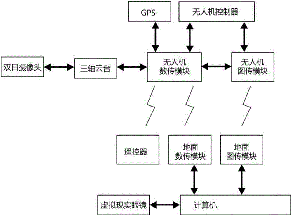
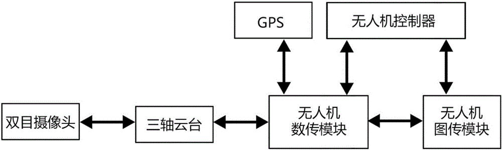
[0028] Such as figure 1 , figure 2 , image 3 , Figure 4 As shown, the present invention includes an airborne device and a ground device, and the airborne device and the ground device are connected wirelessly;
[0029] The airborne device is located on the drone. The three-axis pan/tilt on the drone performs corresponding angle rotation by receiving the head angle information and control instructions of the ground device. The binocular camera mounted on the three-axis pan/tilt will collect the surrounding area. The image of the environment, the flight status of the drone and the location information of the drone are transmitted to the ground device;
[0030] The ground device receives the location information and images sent by the onboard device for analysis, and through the computer augmented reality technology processing of the ground device, the surrounding environment information, road information, traffic information, marking information, and landmark information of the location of the drone are simulated After the simulation, it is superimposed on the real world picture space and presented to the controller through the virtual reality eyepiece.
[0031] Such as image 3 As shown, the airborne device includes a three-axis PTZ, binocular camera, GPS, UAV image transmission module, UAV digital transmission module and UAV control module, three-axis PTZ, GPS, unmanned The drone image transmission module, the drone data transmission module and the drone control module are installed on the drone, the binocular camera is installed on the three-axis PTZ, the binocular camera is connected to the drone image transmission module, GPS, unmanned The aircraft control module is connected with the UAV data transmission module, and the three-axis PTZ is connected with the UAV data transmission module;
[0032] The three-axis pan/tilt is used to keep the binocular camera pointing stably and perform actions according to the angle instructions returned by the virtual reality glasses;
[0033] Binocular camera for collecting images of the surrounding environment of the drone;
[0034] UAV image transmission module, used to transmit the images collected by the binocular camera back to the ground device;
[0035] UAV digital transmission module, used to transmit the GPS positioning information of the UAV to the ground device;
[0036] The UAV control module is used to control the flight status of the UAV.
[0037] Such as Figure 4 As shown, the ground station device includes virtual reality glasses, a computer, a ground image transmission module, a ground data transmission module, and a remote control. The computer is respectively connected to the virtual reality glasses, the ground image transmission module, and the ground data transmission module;
[0038] The ground data transmission module sends the head angle information obtained by the virtual reality glasses to the UAV data transmission module;
[0039] Ground image transmission module for receiving images taken by binocular cameras;
[0040] The computer is used to analyze the collected drone flight height, attitude, GPS positioning information, and process the existing augmented reality technology to simulate the surrounding environment information at the location of the drone and then superimpose it on the real world picture space In, then transmitted to the virtual reality eyepiece;
[0041] Virtual reality glasses are used to display image information superimposed by a computer with an augmented reality effect, and are also used to obtain information about the rotation angle of the head movement.
[0042] The remote control is used to control the flight attitude of the drone.
[0043] In the virtual reality eyepiece, the operator can simultaneously display the virtual information while seeing the real UAV's angle of view. The image information and data information complement each other, and can see all kinds of data information surrounding the real picture.

PUM

no PUM

Description & Claims & Application Information

We can also present the details of the Description, Claims and Application information to help users get a comprehensive understanding of the technical details of the patent, such as background art, summary of invention, brief description of drawings, description of embodiments, and other original content. On the other hand, users can also determine the specific scope of protection of the technology through the list of claims; as well as understand the changes in the life cycle of the technology with the presentation of the patent timeline. Login to view more.

Similar technology patents

Dual-CPU based circuit breaker intelligent controller

Owner:WUHAN NARI LIABILITY OF STATE GRID ELECTRIC POWER RES INST

Classification and recommendation of technical efficacy words

Why Eureka
Try Eureka