Method for calculating soil erosion or deposit volume in karst region by stone forest

A technology of soil erosion and accumulation, applied in soil material testing, material inspection products, etc., can solve problems such as low precision, large error, and difficulty in obtaining model parameters, and achieve multiple economic benefits and high measurement accuracy.

Active Publication Date: 2016-08-10
INST OF GEOCHEM CHINESE ACADEMY OF SCI
View PDF5 Cites 5 Cited by
  • Summary
  • Abstract
  • Description
  • Claims
  • Application Information

AI Technical Summary

Problems solved by technology

[0003] The technical problem to be solved by the present invention is to provide a method for calculating the amount of soil erosion or accumulation in karst areas by using stone forests, so a

Method used


Image

  • Method for calculating soil erosion or deposit volume in karst region by stone forest
  • Method for calculating soil erosion or deposit volume in karst region by stone forest

Examples


Embodiment Construction

[0019] Determination of future soil erosion or accumulation:

[0020] (1) Determination of soil erosion or accumulation in the area:

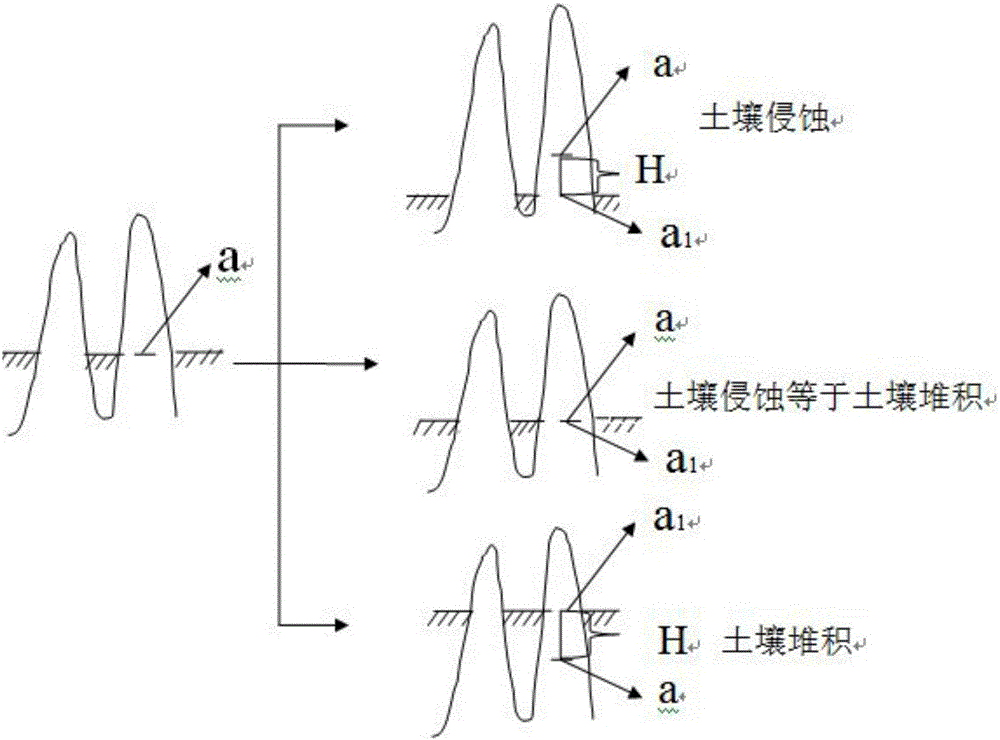
[0021] Step 1: Select an area with gentle strata, and the dip angle of the stratum is less than 10°. If the dip angle of the stratum is greater than 10°, the stone forest is not developed. Select a stone pillar whose height is at the average height of the stone forest. For the square soil layer area with the width of the soil layer contact surface, mark line a at the contact point between the stone pillar and the topsoil layer;

[0022] Step 2, measure the width of the stone pillar passing through the horizontal plane of the marking line a with a theodolite or a level, and mark a square area with an area of ​​S on the adjacent soil layer with the width as the side length;

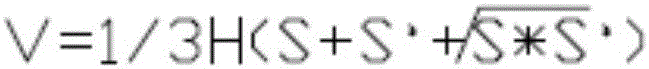
[0023] Step 3, after a shower or every other year, make a marking line a at the contact between the stone pillar and the topsoil layer 1 , use the method of step 2 to meas...


PUM


Abstract

The invention discloses a method for calculating soil erosion or deposit volume in a karst region by a stone forest. The method includes: selecting a stone column, and making a mark line a at a contact position of the stone column and a surface soil layer; measuring the width of the stone column passing through a horizontal plane of the mark line a, and taking the width as a side length to mark a square region with the area being S on an adjacent soil layer; after raining or after one year, making a mark line a1 at the contact position of the stone column and the surface soil layer, measuring the width of the stone column passing through a horizontal plane of the mark line a1, taking the width as a side length to mark a square region with the area being S' on the adjacent soil layer, measuring a variation height H of the stone column from the mark line a to the mark line a1, and taking the height H as a height for measuring volume of erosion or deposit soil; calculating volume V of erosion or deposit soil in the tested region; measuring soil density p of each region; calculating soil erosion or deposit volume A. The method solves the technical problems of low technical precision, large errors, difficulty in model parameter acquisition and the like in the prior art.

Description

Technical field: [0001] The invention belongs to the measurement technology of soil erosion or accumulation in karst areas, in particular to a method for calculating soil erosion or accumulation in karst areas by using stone forests. Background technique: [0002] In the prior art, the runoff plot, needle method, radionuclide tracer method, model estimation and 3S combination method are commonly used to measure soil erosion or accumulation. Runoff plots: due to the roughness and weakness of monitoring methods, the development of ground monitoring level is restricted, soil erosion data for a long period of time cannot be provided, and it is difficult to apply to large-scale spatial changes of soil erosion; the automation degree of the needle method is low, and farming activities will Erosion causes different degrees of disturbance in the surrounding sensitive areas, which is limited by many disadvantages such as environment and man-made; radionuclide tracer method: some model...

Claims


Application Information

Patent Timeline
IPC IPC(8): G01N33/24
CPCG01N33/24
Inventor 白晓永田义超陈秋芹许燕吴路华
Owner INST OF GEOCHEM CHINESE ACADEMY OF SCI
Why Eureka
Try Eureka