
An indoor space surveying and mapping system and surveying and mapping method

An indoor space and surveying and mapping instrument technology, applied in the field of indoor space surveying and mapping systems, can solve the problems of tailor-made design plans, time-consuming, cumbersome methods, etc., and achieve the effect of flexible and free measurement methods, saving manpower and material resources, and saving time.

Active Publication Date: 2018-01-30
马嘉伦
View PDF6 Cites 1 Cited by
  • Summary
  • Abstract
  • Description
  • Claims
  • Application Information

AI Technical Summary

Problems solved by technology

[0003] The above-mentioned measurement and drawing process is very cumbersome and time-consuming. First, the data need to be recorded on paper one by one, and then input into the computer one by one to obtain a standard plan, and then a special effect drawing drafter is required to obtain the effect drawing.
In addition, when measuring indoor space data, it is necessary to manually select the direction of the wall, and the position of doors and windows cannot be automatically located. The method is cumbersome and cannot meet the requirements of use.
[0004] In addition, usually the designer needs to discuss the design plan with the client when he comes to measure the house for the first time. Due to the limitations of existing conditions, he can only show the client some existing renderings or photos, and cannot provide the client with a floor plan on the spot Tailor-made design solutions

Method used


Image

  • An indoor space surveying and mapping system and surveying and mapping method
  • An indoor space surveying and mapping system and surveying and mapping method
  • An indoor space surveying and mapping system and surveying and mapping method

Examples


Embodiment 1

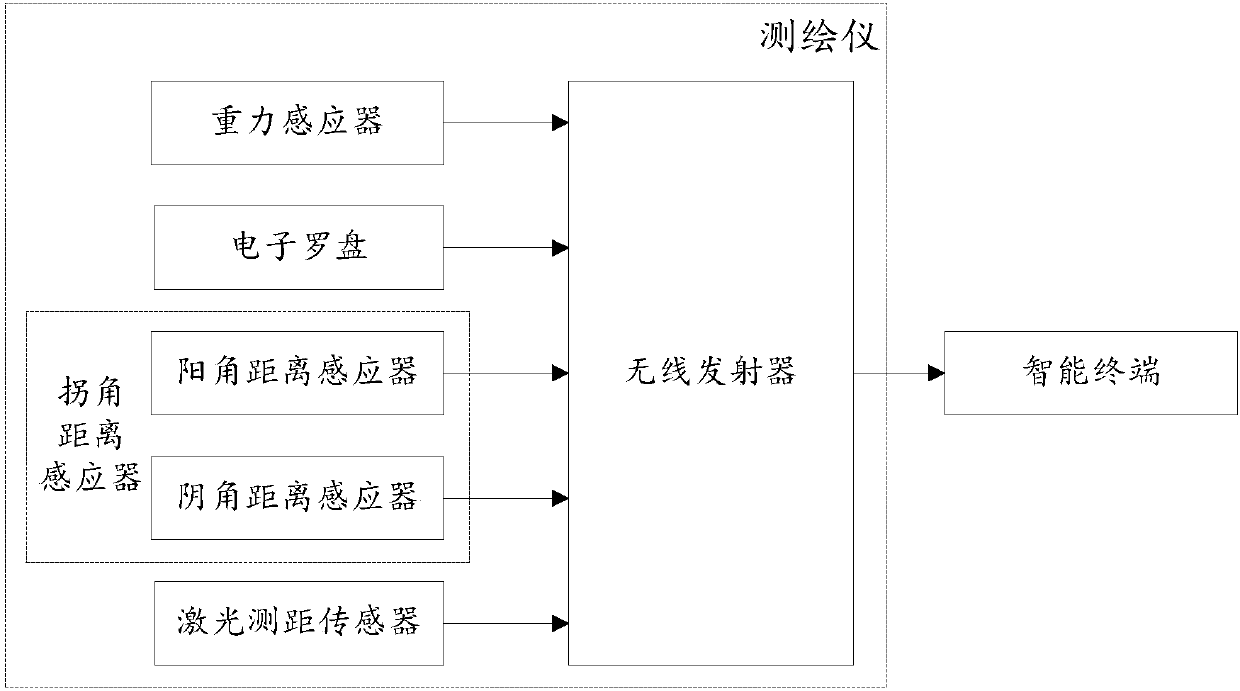
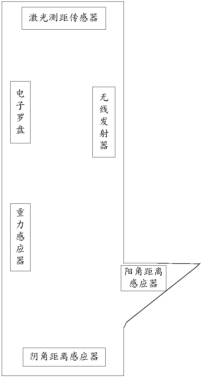
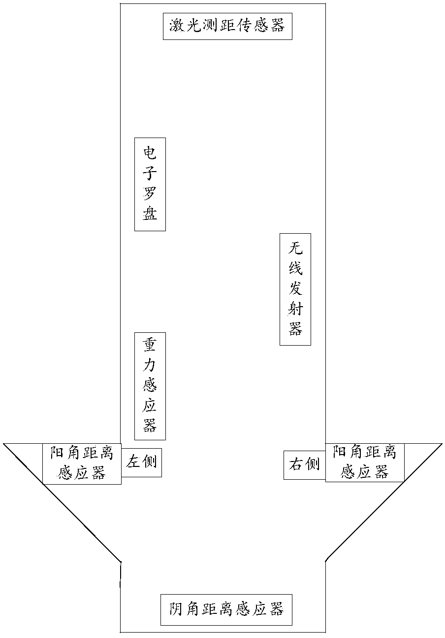
[0028] Embodiment 1. An indoor space surveying and mapping system. The following combination Figure 1 to Figure 3 The indoor space surveying and mapping system provided in this embodiment will be described in detail.

[0029] see Figure 1 to Figure 3 , an indoor space surveying and mapping system provided in this embodiment includes a surveying and mapping instrument and an intelligent terminal. device.

[0030] The surveying instrument is used for surveying and mapping the indoor space in a counterclockwise or clockwise order against the wall.

[0031] The electronic compass is used to sense the plane measurement direction, obtain the plane direction value and send it to the wireless transmitter.

[0032] The gravity sensor is used to sense the height measurement direction, obtain the height direction value and send it to the wireless transmitter.

[0033] The laser distance measuring sensor is arranged at a position close to the top inside the surveying instrument, an...

Embodiment 2

[0053] Embodiment 2, a method for indoor space surveying and mapping. The following combination Figure 4 to Figure 6 A method for surveying and mapping an indoor space provided in this embodiment is described in detail.

[0054] see Figure 4 to Figure 6 , S1. The surveying instrument sticks to the wall and surveys and maps the indoor space counterclockwise or clockwise. The electronic compass senses the plane measurement direction, obtains the plane direction value and sends it to the wireless transmitter, and the gravity sensor senses measure the direction of height, obtain the value of height direction and send it to the wireless transmitter.

[0055] Specifically, the surveying instrument surveys and maps the indoor space in order against the wall, specifically refers to measuring along the wall clockwise or counterclockwise, such as Figure 5 and Figure 6 shown. The electronic compass senses the direction change of plane measurement, which is specifically direction...


PUM


Abstract

The invention discloses an indoor space surveying and mapping system and method. The system comprises a surveying and mapping instrument and an intelligent terminal. The surveying and mapping instrument is of a stereochemical structure. An electronic compass, a laser distance measuring sensor, a gravity sensor, a corner distance sensor and a wireless emitter are arranged in the surveying and mapping instrument. The surveying and mapping instrument is adopted for surveying and mapping indoor space anticlockwise or clockwise, the wall direction can be automatically recognize, wall length distance data and wall height distance date can be automatically measured, the wall corner type can be determined, and the areas such as a door, a window and a corridor which does not need to be measured can be automatically recognized. The intelligent terminal automatically draws a three-dimensional space model of the indoor space according to the data obtained through measurement of the surveying and mapping instrument, operation is convenient, intelligent and rapid, time is saved, manpower and material resources are saved, all operations are automatically completed through the instrument, and practicability is high.

Description

technical field [0001] The invention relates to the technical field of interior design, in particular to an indoor space surveying and mapping system and a surveying and mapping method. Background technique [0002] The process of interior design usually starts with measuring the room. The designer first visually observes and draws the outline of the room, then starts from a reference point and uses a ruler clockwise or counterclockwise to measure the wall one by one, and marks the length data next to the outline. Then use the cad software on the computer to draw the floor plan, and mark the location of the furniture, then export the cad floor plan to the 3D software, draw the room model with the height data, put it into the furniture model, and finally use the lights and cameras to render the picture before it can be given to the customer Present preliminary proposals. [0003] The above-mentioned measurement and drawing process is very cumbersome and time-consuming. First...

Claims


Application Information

Patent Timeline
Patent Type & Authority Patents(China)
IPC IPC(8): G01C15/00
CPCG01C15/00
Inventor 马嘉伦龚志成
Owner 马嘉伦
Learn More