Road name data compiling method and map labeling method and device

A road name and data compilation technology, which is applied in the direction of electronic digital data processing, structured data retrieval, geographic information database, etc., can solve the problems of inability to dynamically adjust, lack of flexibility and mobility of road names, etc., to improve flexibility and The effect of mobility

Active Publication Date: 2016-08-24
TENCENT TECH (SHENZHEN) CO LTD +1
View PDF3 Cites 14 Cited by
  • Summary
  • Abstract
  • Description
  • Claims
  • Application Information

AI Technical Summary

Problems solved by technology

[0004] However, the existing road names are marked in the way of pre-buried points, and the road names are marked at fixed positions in the ma

Method used


Image

  • Road name data compiling method and map labeling method and device
  • Road name data compiling method and map labeling method and device
  • Road name data compiling method and map labeling method and device

Examples


Embodiment Construction

[0046] Typical embodiments that embody the features and advantages of the present invention will be described in detail in the following description. It should be understood that the present invention is capable of various changes in different embodiments without departing from the scope of the present invention, and that the description and illustrations therein are illustrative in nature and not limiting. this invention.

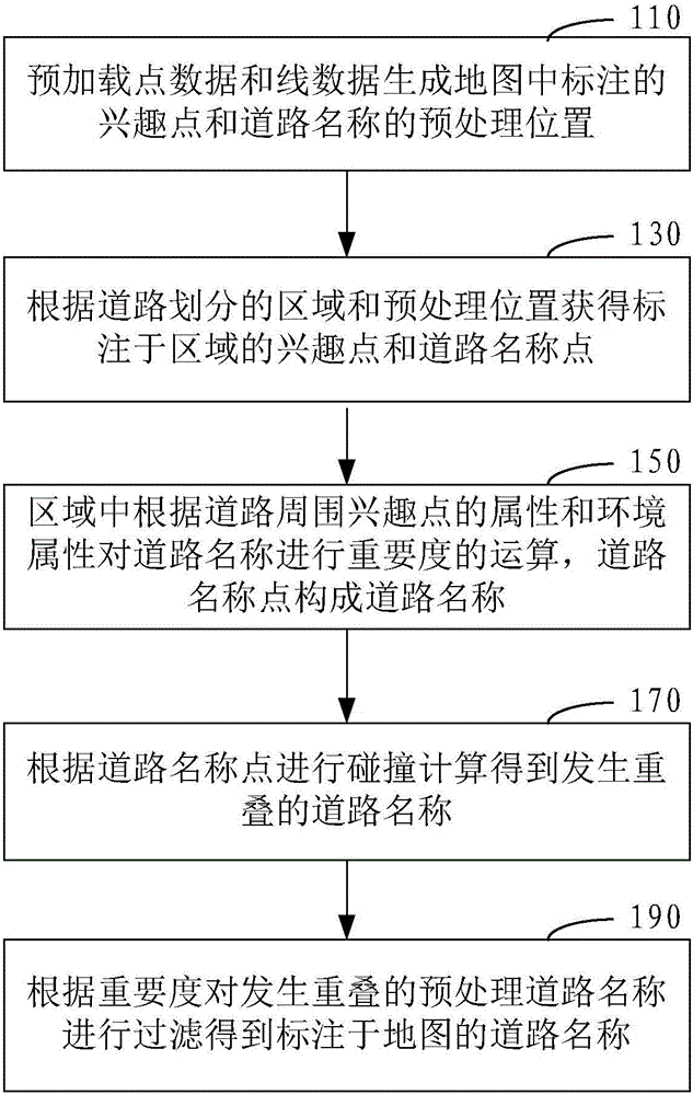
[0047] In one embodiment, a road name data compilation method such as figure 1 shown, including the following steps:

[0048] Step 110, preload point data and line data to generate preprocessed positions of points of interest and road names marked in the map.

[0049] Both point data and line data are original road data, which are extracted from basic data for map display. Basic data includes a lot of data content, and point data and line data are part of the data content it includes.

[0050] Point data is used to store the attributes of points of int...


PUM


Abstract

The invention provides a road data compiling method. The method comprises the steps that point data and line data are preloaded to generate preprocessing positions of interest points and road name points which are labeled in a map; according to an area divided by roads and the preprocessing positions, interest points and road name points which are labeled in the area are obtained; calculation of importance is conducted on the road names according to attributes of the interest points around the roads and environmental attributes in the area, wherein the road name points form the road names; collision calculation is conducted according to the road name points, and overlapped road names are obtained; the overlapped road names are filtered according to the importance, and the road names labeled in the map are obtained. In addition, the invention further provides a road name data compiling device matched with the method and a map labeling method and device. By means of the road name data compiling method and the map labeling method and device, dynamic adjustment of road names themselves in road name labeling can be conducted, and the flexibility and maneuverability are improved.

Description

technical field [0001] The invention relates to the technical field of maps, in particular to a method for compiling road name data, a method and a device for marking maps. Background technique [0002] With the continuous application of mobile navigation technology, more and more people begin to rely on maps for route guidance during travel, improving the convenience and accuracy of people's wayfinding. [0003] At present, map products generally provide the basic data for map display to the navigation engine, so as to realize the rendering of the map in the local client. The rendering of the road name label is included in the map rendering realized by the basic data, that is, the road name labeling is performed for each road in the displayed map. [0004] However, the existing road names are marked in the way of pre-buried points, and the road names are marked at fixed positions in the map, and cannot be dynamically adjusted by themselves, which will make the marking of r...

Claims


Application Information

Patent Timeline
IPC IPC(8): G06F17/30
CPCG06F16/29G06F16/9537
Inventor 吴统帅
Owner TENCENT TECH (SHENZHEN) CO LTD
Why Eureka
Try Eureka