Improved navigation method and system for walking based on virtual reality

A technology of virtual reality and pedestrian navigation, applied in the field of navigation, can solve the problem that pedestrian navigation cannot meet the individual needs of users, and achieve the effect of increasing fun

Active Publication Date: 2016-08-31
南京天枢星图信息技术有限公司
View PDF7 Cites 1 Cited by
  • Summary
  • Abstract
  • Description
  • Claims
  • Application Information

AI Technical Summary

Problems solved by technology

At the same time, most of the existing navigation solutions focus on the shortest navigation path, or simply divide them into walking, self-driving, and bus options, making walking navigation unable to meet the individual needs of users.

Method used


Image

  • Improved navigation method and system for walking based on virtual reality
  • Improved navigation method and system for walking based on virtual reality

Examples


Embodiment Construction

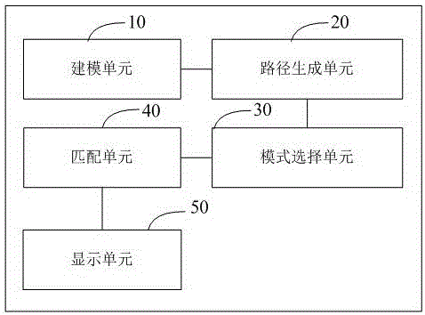
[0061] Such as figure 1 As shown, an improved walking navigation method based on virtual reality includes the following steps:

[0062] S1. Extract feature information of scenic spots and landmarks and establish a three-dimensional model of scenic spots; preset scene modes to generate a three-dimensional model of scenic spots and landmarks and a mapping table of scene mode information; store the three-dimensional model and mapping table of scenic spots and landmarks in the scenic spot database.

[0063] The landmarks can be famous mountains, famous buildings, man-made attractions, and so on. According to the characteristics of these attractions and landmarks, scene modes such as natural scenery, high-rise buildings, historical buildings, etc., can also be further divided according to the style of the building, such as European style, southern town, etc., which can be set in advance.

[0064] S2. Obtain the navigation start and end information entered by the user and the scene mode se...


PUM


Abstract

The invention provides an improved navigation method for walking based on virtual reality. The method comprises the following steps: S1, extracting characteristic information of sight spot landmarks, establishing three-dimensional models of the sight spot landmarks, presetting scene modes and generating a mapping table for the three-dimensional models of the sight spot landmarks and information of the scene modes; S2, acquiring information of navigation starting and ending points input by a user and a scene mode selected by the user, generating preliminary navigation path sections according to the information of the navigation starting and ending points, correcting the preliminary navigation path sections according to the option of the user so as to obtain a navigation path, and acquiring three-dimensional information of buildings on the navigation path; S3, using the three-dimensional models of all the sight spot landmarks in the scene mode as a candidate set; S4, screening out the three-dimensional model of a sight spot landmark matching with the length of the navigation path and the three-dimensional information of the buildings from the candidate set according to the length of the navigation path and the three-dimensional information of the buildings; and S5, mixing virtual and actual reality and displaying the navigation path on VR equipment.

Description

Technical field [0001] The present invention relates to the technical field of navigation, in particular to an improved walking navigation method and system based on virtual reality. Background technique [0002] Navigation equipment refers to equipment that uses positioning systems to provide route guidance for moving objects such as vehicles. Existing navigation equipment mainly uses positioning systems to provide users with navigation services. Specifically, the navigation device provides a navigation map for the user, and the navigation path is displayed in the navigation map, and the estimated time taken from the current location to the destination. [0003] Virtual reality (virtual reality, VR) technology is a computer simulation system that can create and experience a virtual world. It uses a computer to generate a simulation environment. It is an interactive three-dimensional dynamic vision and entity behavior system that integrates multi-source information. Simulation im...

Claims


Application Information

Patent Timeline
Patent Type & Authority Applications(China)
IPC IPC(8): G01C21/34
CPCG01C21/3638G01C21/3641
Inventor 胡奕清
Owner 南京天枢星图信息技术有限公司
Why Eureka
Try Eureka