Scalar-estimation-algorithm-based INS/GNSS combined navigation method

A scalar estimation and integrated navigation technology, applied in the field of navigation, can solve the problems of poor reliability and low accuracy

Inactive Publication Date: 2016-10-05
NANJING UNIV OF SCI & TECH
View PDF4 Cites 10 Cited by
  • Summary
  • Abstract
  • Description
  • Claims
  • Application Information

AI Technical Summary

Problems solved by technology

[0006] The object of the present invention is to provide a kind of INS/GNSS integrated navigation method based on scalar estimation algorithm, overcome the traditional integrated navigation system based on inertial navigation and satellite positioning when the Kalman filter diverges, t...

Method used


Image

  • Scalar-estimation-algorithm-based INS/GNSS combined navigation method
  • Scalar-estimation-algorithm-based INS/GNSS combined navigation method
  • Scalar-estimation-algorithm-based INS/GNSS combined navigation method

Examples


Embodiment Construction

[0098] The present invention will be described in further detail below in conjunction with the accompanying drawings.

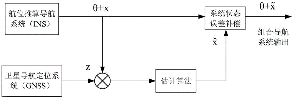
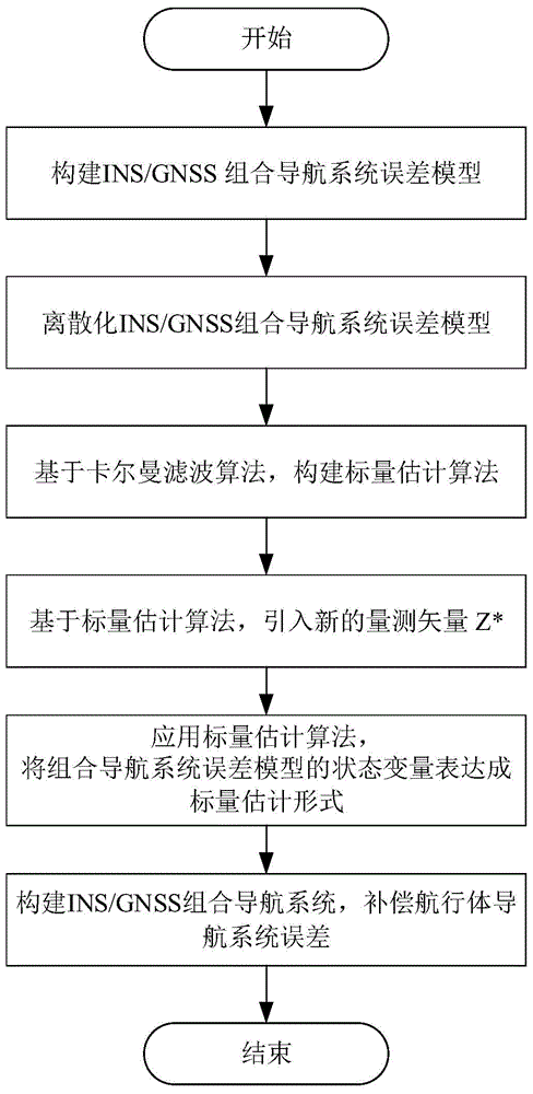
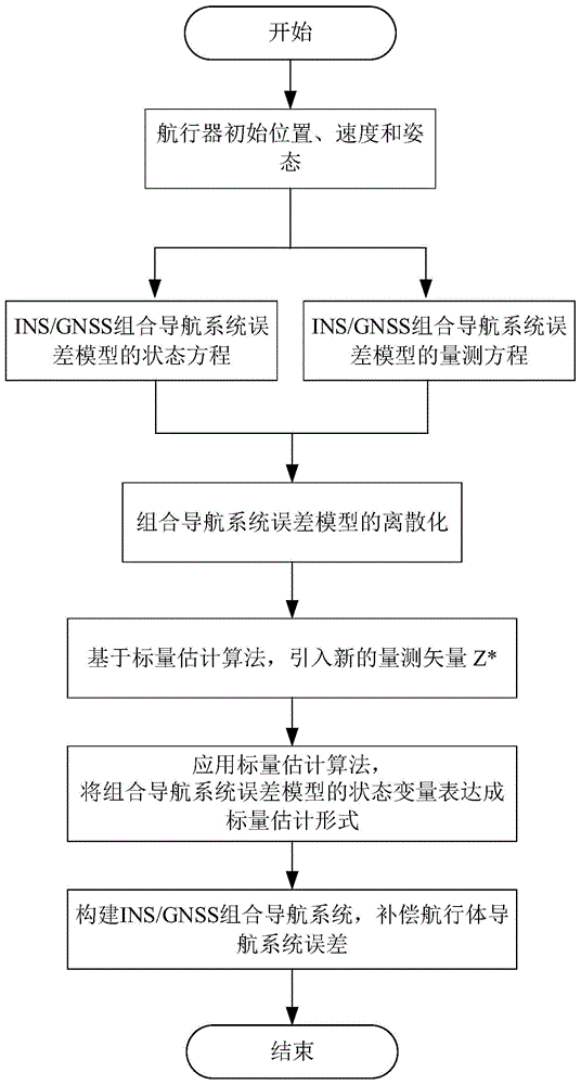
[0099] An INS / GNSS integrated navigation method based on a scalar estimation algorithm, its specific implementation method is: establish an INS / GNSS integrated navigation system error model, discretize the INS / GNSS integrated navigation system error model, and propose a compact scalar estimation algorithm, and propose a construction system measurement vector z * The new method of the paper uses the scalar estimation algorithm to express each state variable in the error model of the integrated navigation system as a scalar estimation form of linear combination of other state variables, combined with figure 1 The INS / GNSS integrated navigation system is constructed, and errors such as position, velocity, attitude and orientation of the integrated navigation system are corrected according to the scalar estimation expression, and the error compensation of...


PUM


Abstract

The invention discloses a scalar-estimation-algorithm-based INS/GNSS combined navigation method. According to different error dynamic characteristics of a dead reckoning technology and a satellite navigation positioning technology, the two kinds of navigation methods are combined based on a scalar estimation algorithm to construct an INS/GNSS combined navigation system. The method comprises: a discretized INS/GNSS combined navigation system error model is established; on the basis of a kalman filtering algorithm, a scalar estimation algorithm is constructed; on the basis of the scalar estimation algorithm, a new measurement vector Z* is introduced; a state variable of the combined navigation system error model is expressed into a scalar estimation mode by using the scalar estimation algorithm; and then on the basis of the scalar estimation mode, an INS/GNSS combined navigation system is constructed and thus a navigation body navigation system error is compensated. According to the invention, a filter divergence problem caused by inaccurate noise statistic characteristic determination of the traditional kalman filtering algorithm can be solved; reliability of the combined navigation system is improved; and the combined navigation system cost is reduced. A novel combined navigation method is provided.

Description

technical field [0001] The invention relates to the technical field of navigation, in particular to an INS / GNSS integrated navigation method based on a scalar estimation algorithm. Background technique [0002] The inertial navigation system (INS) uses inertial sensitive elements (accelerometers and gyroscopes) to measure the linear motion and angular motion parameters of the vehicle relative to the inertial space, and calculates the position and velocity of the vehicle under the given initial motion parameters. It is a dead reckoning navigation system that guides the navigational body to complete the predetermined navigational tasks, such as navigation parameters and attitude. Since the inertial navigation method is based on Newton's laws of mechanics, it does not rely on any external measurement information, and is not disturbed by natural or human factors. Therefore, the inertial navigation system has strong autonomy, complete navigation parameters, high short-term accura...

Claims


Application Information

Patent Timeline
IPC IPC(8): G01S19/49
Inventor 何勇K.A.聂吾希斌沈凯A.V.普列达尔斯基郭锐刘荣忠
Owner NANJING UNIV OF SCI & TECH
Why Eureka
Try Eureka