Multi-scale debris flow risk assessment method for earthquake disturbance area

A risk assessment and debris flow technology, applied in special data processing applications, instruments, electrical digital data processing, etc., can solve problems such as weakness, worsening people's lives in disaster areas, and non-standard evaluation accuracy

Pending Publication Date: 2016-10-12
LANZHOU UNIVERSITY
View PDF3 Cites 27 Cited by
  • Summary
  • Abstract
  • Description
  • Claims
  • Application Information

AI Technical Summary

Problems solved by technology

Due to the lack of perfect debris flow basic data and effective risk assessment technology after the strong earthquake disturbance, it is difficult to carry out risk assessment, monitoring and early warning of potential debris flow geological disasters, such as the Zhouqu debris flow disaster in ...

Method used


Image

  • Multi-scale debris flow risk assessment method for earthquake disturbance area
  • Multi-scale debris flow risk assessment method for earthquake disturbance area
  • Multi-scale debris flow risk assessment method for earthquake disturbance area

Examples


Embodiment 1

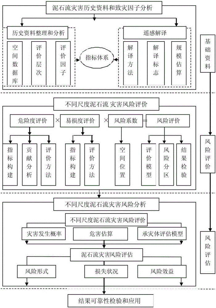
[0026] A multi-scale debris flow risk assessment method in an earthquake disturbance area, comprising the following steps:

[0027] (1) Establish a spatial database: collect recent earthquakes, historical earthquakes, and earthquake-induced debris flow data in the seismically disturbed area, and combine remote sensing image interpretation to investigate the current situation of debris flow geological disasters and their background, and clarify the main controlling factors and causes of regional debris flows. Its contribution rate, establishing a spatial database of historical earthquakes and their induced debris flows;

[0028] (2) Establish risk assessment level and scale requirements: According to the principles of assessment scale, assessment level, assessment data, assessment methods and results release, carry out risk assessment at different spatial scales from region→small watershed→small gully→secondary gully→small gully Debris flow hazard or risk assessment;

[0029] ...

Embodiment 2

[0042] Example 2: Risk assessment of debris flow at different scales

[0043] 1. Construction of evaluation index system

[0044] (1) Regional debris flow assessment index system

[0045] The regional debris flow risk assessment index system generally includes five categories: topography, hydrology and meteorology, geological conditions, and human engineering activities. Specifically, it can be divided into nine index parameters: elevation, slope, landslide point density, comprehensive precipitation index, stratum lithology, structural buffer zone, earthquake, land use, and vegetation index. Using the method of information volume, AHP and GIS technology to obtain the index weight.

[0046] (2) Evaluation index system for different scales of debris flow in small watersheds

[0047] Small watersheds can be divided into three scales of debris flow gullies: small ditch, secondary ditch, and young ditch, and different evaluation index systems have been established for the risk a...

Embodiment 3

[0055] Example 3: Vulnerability Evaluation

[0056] 1. Evaluation index system

[0057] For small- and medium-scale vulnerability assessment, from the perspective of life and property, the vulnerability assessment of small and medium-scale hazard-bearing bodies can be divided into population vulnerability, economic and ecological environment vulnerability, among which population vulnerability represents the vulnerability of life. The degree of potential loss, economic and ecological vulnerability characterizes the loss of property classes. Economic and ecological vulnerability includes two aspects: economic vulnerability and ecological vulnerability. Economic vulnerability mainly refers to the situation of fixed assets and social production in the evaluation area, specifically: building density, agricultural output value density, forestry output value density , output value density of agriculture, forestry and animal husbandry supporting services, road network density, and pu...


PUM


Abstract

The invention discloses a multi-scale debris flow risk assessment method for an earthquake disturbance area. The method comprises the steps of 1, establishing a spatial database; 2, establishing risk assessment levels and scale demands; 3, establishing risk control and management measure and suggestion demands; and 4, carrying out debris flow risk assessment, comprising four steps of debris flow probability of occurrence assessment, harm assessment, risk evaluation and risk assessment. According to the method, the debris flow dangerousness evaluation, vulnerability evaluation, risk evaluation and risk assessment technical operations for the earthquake disturbance area are stipulated; therefore, the technical basis is provided for carrying out multi-spatial scale risk assessment, control and management work on the debris flows evoked by recent earthquakes or historical earthquakes in the strong earthquake influence area; and the method is applicable to the multi-scale debris flows with scales of 1: 100,000 -1:1000 and the debris flow risk assessment, control and management technical operations for the earthquake disturbance area.

Description

technical field [0001] The invention relates to the technical field of mud-rock flow risk assessment, in particular to a method for multi-scale mud-rock flow risk assessment in an earthquake disturbance area. Background technique [0002] In recent years, debris flow disasters have become more and more frequent, and the economic losses caused by them have also increased. There are many mountains in western China, heavy rainfall is concentrated, and geological conditions are complex, which has become one of the hardest-hit areas of debris flow disasters. Especially after the "Wenchuan Earthquake", large-scale debris flow disasters have occurred in the hardest-hit areas of Longnan, Gansu and Sichuan for five consecutive years. Due to the lack of perfect debris flow basic data and effective risk assessment technology after the strong earthquake disturbance, it is difficult to carry out risk assessment, monitoring and early warning of potential debris flow geological disasters,...

Claims


Application Information

Patent Timeline
IPC IPC(8): G06F19/00
CPCG16Z99/00
Inventor 顾春杰舒和平马金珠齐识张鹏
Owner LANZHOU UNIVERSITY
Why Eureka
Try Eureka