Airborne laser point cloud data and vehicle laser point cloud data fusion method

A point cloud data, vehicle-mounted laser technology, applied in the field of image processing, to achieve the effect of precise correction, improved accuracy and simple operation

Inactive Publication Date: 2016-10-26
CAPITAL NORMAL UNIVERSITY +1
View PDF5 Cites 16 Cited by
  • Summary
  • Abstract
  • Description
  • Claims
  • Application Information

AI Technical Summary

Benefits of technology

This patented technology collects both aerially collected laser points from vehicles or ground based devices (VL) on different areas without any differences between them. It then uses this gathered data to accurately correct errors caused during the process. By doing these operations efficiently, it allows for effective use of space resources while also improving the quality of the final resultant image.

Problems solved by technology

This patented technical problem addressed in this patents relates to improving the efficiency at which vehicles use aerial or vehicular laser systems to gather accurate geographic location (latitude) values from their surrounding areas during urban planning operations. Current methods such as combining different types of sensors like cameras and radars together may result in poor alignment due to differences between sensor readings caused by factors like atmospheric conditions and signal interference.

Method used


Image

  • Airborne laser point cloud data and vehicle laser point cloud data fusion method
  • Airborne laser point cloud data and vehicle laser point cloud data fusion method

Examples


Embodiment Construction

[0055] The following will clearly and completely describe the technical solutions in the embodiments of the present invention with reference to the accompanying drawings in the embodiments of the present invention. Obviously, the described embodiments are only some, not all, embodiments of the present invention. Based on the embodiments of the present invention, all other embodiments obtained by persons of ordinary skill in the art without making creative efforts belong to the protection scope of the present invention.

[0056] The purpose of the present invention is to provide a fusion method of airborne laser point cloud data and vehicle laser point cloud data.

[0057] In order to make the above objects, features and advantages of the present invention more comprehensible, the present invention will be further described in detail below in conjunction with the accompanying drawings and specific embodiments.

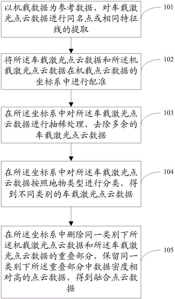
[0058] figure 1 It is a method flow chart of an embodiment of the...


PUM


Abstract

The invention discloses an airborne laser point cloud data and vehicle laser point cloud data fusion method, comprising: employing airborne data as reference data to extract homonymy points or same characteristic lines of vehicle laser point cloud data; matching the vehicle laser point cloud data and airborne laser point cloud data in a vehicle laser point cloud data coordinate system; performing thinning treatment on the vehicle laser point cloud data in the coordinate system, and removing superfluous vehicle laser point cloud data; classifying the vehicle laser point cloud data in the coordinate system according to ground object types, and obtaining vehicle laser point cloud data of different types; and deleting the overlapped section between the airborne laser point cloud data and the vehicle laser point cloud data under the same category in the coordinate system, maintaining the point cloud data with relatively high data density in the overlapped section under the same category, and obtaining fused point cloud data. The scheme overcomes the difference of resolution ratio and data size between two types of data, and can well fuse the two types of data.

Description


Claims


Application Information

Patent Timeline
Owner CAPITAL NORMAL UNIVERSITY
Why Eureka
Try Eureka