Panorama displaying method of unmanned aerial vehicle image

A drone and panorama technology, applied in still image data retrieval, still image data browsing/visualization, special data processing applications, etc., can solve problems such as insufficient records of urban development, and achieve better visual effects and better cities Development and change, strong time-sensitive effect

Inactive Publication Date: 2016-11-09
深圳市创驰蓝天科技发展有限公司
View PDF8 Cites 12 Cited by
  • Summary
  • Abstract
  • Description
  • Claims
  • Application Information

AI Technical Summary

Problems solved by technology

[0004] The above technology has solved the application of common panorama pictures very well, but it is not perfect enough for the record of urban development

Method used


Image

  • Panorama displaying method of unmanned aerial vehicle image

Examples


Embodiment

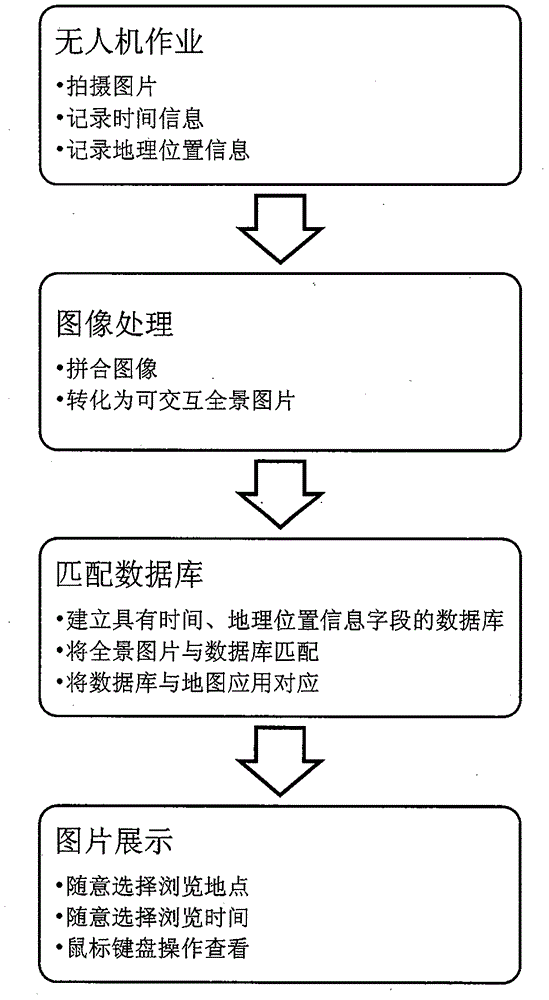
[0025] 1) Select a shooting location and make preparations for shooting;

[0026] 2) The UAV performs the shooting operation, and records the time and geographic location information;

[0027] 3) Carry out stitching image processing and convert it into an interactive panoramic image;

[0028] 4) Establish a database containing geographic location information and time;

[0029] 5) matching the panoramic picture with the database;

[0030] 6) By associating the database with the gis application map, you can directly find the corresponding panoramic picture on the map;

[0031] 7) The user selects the place and time to browse, and reads the previous images at any time.

[0032] The beneficial effects of the present invention are: compared with satellite pictures, the images collected by the aerial perspective of UAVs have a larger angle difference, and can better compare architectural changes; compared with satellite pictures, the images taken by UAVs Clearer and more time-se...


PUM


Abstract

The invention discloses a panorama displaying method of an unmanned aerial vehicle image. The panorama displaying method comprises the following steps: 1) an unmanned aerial vehicle collects a photo with geographic position information and time; 2) the photo collected by the unmanned aerial vehicle is converted into an interactive panorama picture; 3) a database with the time and the geographic position information is established, and the panorama picture and the database are corresponded; and 4) the client side displays the panorama picture. By use of the panorama displaying method of the unmanned aerial vehicle image, the unmanned aerial vehicle which is an emerging tool is used for carrying out periodic shooting on the new panorama picture, a display system can be cooperated to not only display city elegant demeanour and the change process of the city at a clear large viewing angle but also visually, efficiently and comparatively show image data.

Description

technical field [0001] The invention belongs to the field of graphic information processing and transmission, and in particular relates to a method for displaying a panoramic image of an unmanned aerial vehicle. Background technique [0002] Panoramic picture display is a unique image display method, the intelligent method for rapidly generating high-definition panoramas based on round fisheye or drum-shaped images disclosed by Chinese invention patent specification CN1707354A (public date: December 14, 2005), Chinese invention patent The method disclosed in the specification CN1707355A (published on December 14, 2005) based on six drum-shaped images to generate a full spherical panorama. [0003] A method for combining panoramic images with geographic information systems has been discovered, and a method for constructing panoramic electronic map services disclosed in Chinese Invention Patent Specification (Chinese Patent No. ZL 200610026274.3, authorized announcement date M...

Claims


Application Information

Patent Timeline
Patent Type & Authority Applications(China)
IPC IPC(8): G06F17/30
CPCG06F16/54G06F16/5866
Inventor 桂旭阳
Owner 深圳市创驰蓝天科技发展有限公司
Why Eureka
Try Eureka