
Method for improving positioning accuracy of satellite-based augmentation system based on partition correction

A satellite-based enhancement system and positioning accuracy technology, which is applied in satellite radio beacon positioning systems, radio wave measurement systems, measurement devices, etc., can solve the limitations of positioning accuracy improvement, long data processing convergence time, and inability to meet wide-area requirements. User positioning requirements and other issues to achieve the effect of improving positioning accuracy and refining error correction

Active Publication Date: 2018-08-24
SHANGHAI ASTRONOMICAL OBSERVATORY CHINESE ACAD OF SCI
View PDF6 Cites 0 Cited by
  • Summary
  • Abstract
  • Description
  • Claims
  • Application Information

AI Technical Summary

Problems solved by technology

[0007] However, the processing technology of the existing satellite-based augmentation system has the following problems: (1) only the pseudo-range observation is used, and the wide-area differential correction is affected by the pseudo-range accuracy, which limits the improvement of the positioning accuracy; (2) if the phase Observations, due to the ambiguity and cycle slips in the phase observations, the corresponding data processing has a problem of long convergence time; (3) the correction of the space propagation segment (mainly the ionosphere) is also based on the pseudorange observations. There are limits to the improvement of positioning accuracy
[0008] Since the current satellite-based enhancement processing only uses pseudo-range observation data, its service accuracy is limited to the meter level, and its positioning accuracy can only reach a maximum of about 1m, which cannot meet the higher-precision positioning needs of wide-area users

Method used


Image

  • Method for improving positioning accuracy of satellite-based augmentation system based on partition correction
  • Method for improving positioning accuracy of satellite-based augmentation system based on partition correction
  • Method for improving positioning accuracy of satellite-based augmentation system based on partition correction

Examples


Embodiment Construction

[0034] According to the attached Figure 1-2 , give a preferred embodiment of the present invention, and give a detailed description, so that the functions and characteristics of the present invention can be better understood.

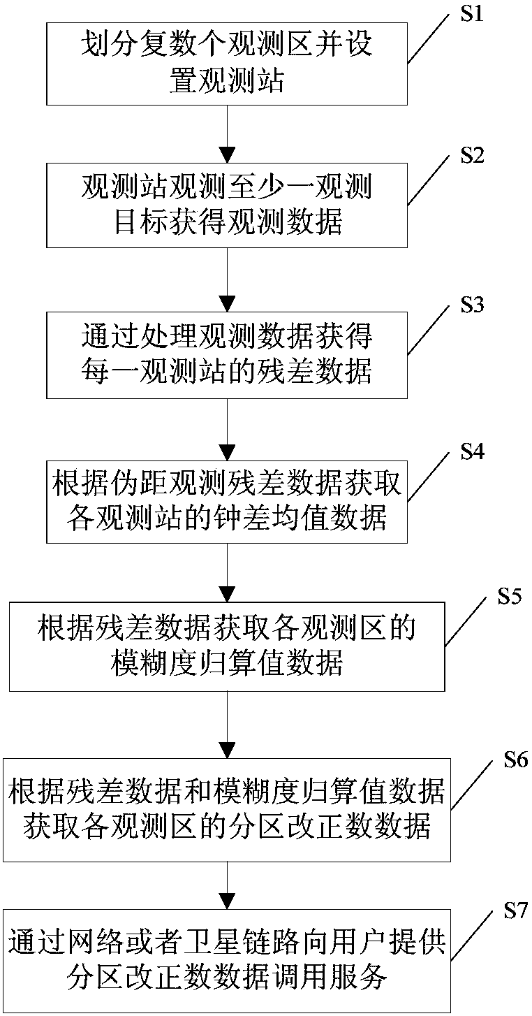
[0035] see figure 1 , a method for improving positioning accuracy of a satellite-based augmentation system based on partition correction of the present invention, comprising the steps of:

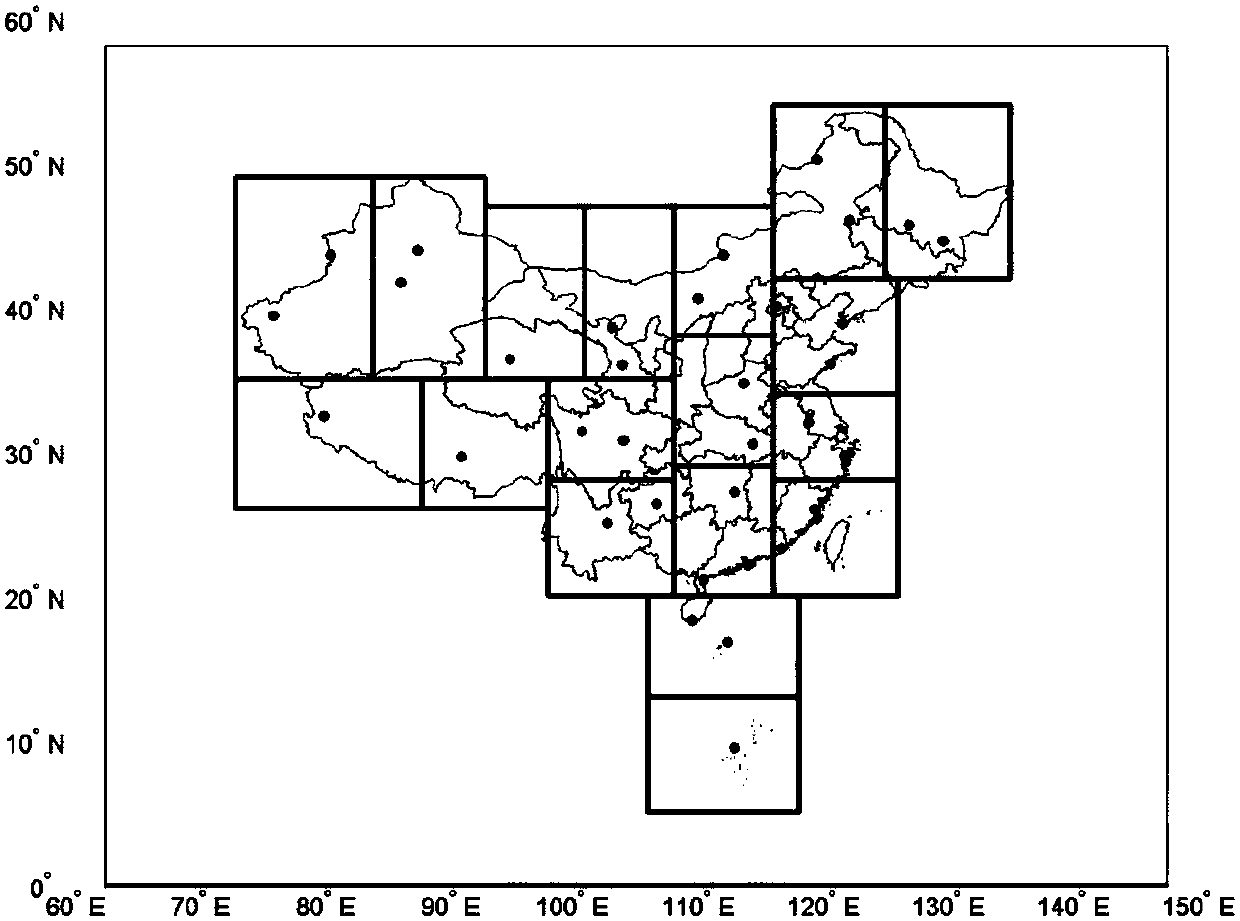
[0036] S1: Divide an area to be observed into a plurality of observation areas, and set up a plurality of observation stations in each observation area;

[0037] S2: The observation station observes at least one observation target to obtain observation data;

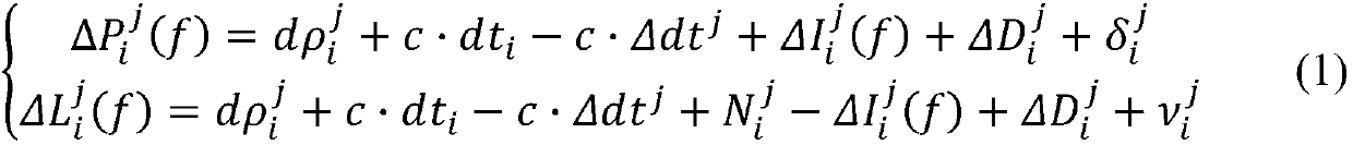
[0038] S3: Obtain the residual data of each observation station by processing the observation data, the residual data includes pseudorange observation residual data and phase observation residual data;

[0039] Specifically, in step S3, the pseudorange observation residual error of an i-th observation stati...


PUM


Abstract

A zone correction-based method for improving positioning accuracy in a satellite-based augmentation system, including: dividing an area to be observed into a plurality of observation areas, and configuring a plurality of monitoring stations in each observation area; acquiring residual of each monitoring station by processing observation data; acquiring mean clock error value of each monitoring station according to observation residual; acquiring ambiguity reduction value of each observation area according to residual data; acquiring zone corrections of each observation area according to residual data and ambiguity reduction value data; and providing a user with a zone corrections calling service by means of a network or a satellite link. The method carries out wide-range area configuration to monitoring stations and calculates the zone corrections for use in network and satellite-based broadcasts on the basis of the monitoring stations to refine error correction in user positioning.

Description

technical field [0001] The invention relates to the field of wide-area satellite-based augmentation, in particular to a method for improving positioning accuracy of a satellite-based augmentation system based on partition correction. Background technique [0002] The services provided by the Global Navigation Satellite System (GNSS) include basic navigation and satellite-based augmentation. Among them, in order to improve the accuracy of real-time service of the system, the basic idea of ​​satellite-based augmentation is to distinguish the main error sources such as satellite orbit error, satellite clock error and ionospheric delay, and establish a model of each error source to correct these errors in basic navigation. parameter error. These calculated corrections are called wide-area differential corrections, and the satellite telegraph system broadcasts the wide-area differential corrections to users through satellite links. [0003] The current navigation augmentation s...

Claims


Application Information

Patent Timeline
Patent Type & Authority Patents(China)
IPC IPC(8): G01S19/41
CPCG01S19/41G01S19/07G01S19/44G01S19/11
Inventor 陈俊平张益泽杨赛男巩秀强胡一帆陈倩
Owner SHANGHAI ASTRONOMICAL OBSERVATORY CHINESE ACAD OF SCI
Learn More