Building contour extraction method of aviation remote sensing image

A technology of aerial remote sensing and extraction method, which is applied in image analysis, image enhancement, image data processing, etc. It can solve the problems of small stereoscopic size and the influence of extracting the outline of urban buildings in a large range, so as to reduce the amount of calculation and complexity , Improve the accuracy, improve the degree of automation and the effect of precision

Active Publication Date: 2016-11-16
WUHAN UNIV
View PDF2 Cites 23 Cited by
  • Summary
  • Abstract
  • Description
  • Claims
  • Application Information

AI Technical Summary

Problems solved by technology

However, the problem with this type of method is that the three-dimensional relative format is ...

Method used


Image

  • Building contour extraction method of aviation remote sensing image
  • Building contour extraction method of aviation remote sensing image
  • Building contour extraction method of aviation remote sensing image

Examples


Embodiment Construction

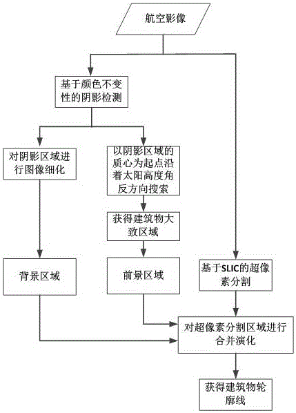
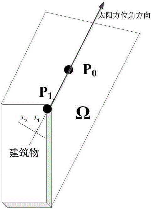
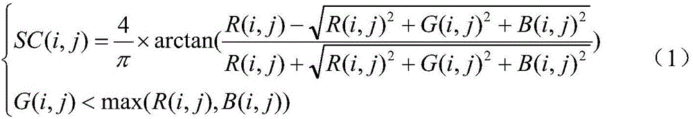
[0020] The present invention proposes a method for extracting building contours from aerial remote sensing images. The method first uses color invariance to detect shadow areas of buildings in aerial remote sensing images, and refines the shadow areas. The result of refinement is used as The background area of ​​the building; then start from the center of mass of the shadow area and search in the opposite direction of the sun elevation angle to obtain the area of ​​the building part, and use this area as the target area of ​​​​the building; use the SLIC algorithm to perform superpixel segmentation on aerial images; Based on the background area and the target area obtained above, the maximum similarity is used to merge the superpixel division blocks to extract the outline of the building. Below in conjunction with accompanying drawing and embodiment describe in detail the technical scheme of the present invention, flow chart is as follows figure 1 As shown, the technical soluti...


PUM


Abstract

The invention provides a building contour extraction method of an aviation remote sensing image. A color invariant algorithm is used to detect the shadow area in the building in the aviation remote sensing image, the shadow area is subjected to image refinement, and a refinement result is used as the background area of the building. With the center of mass of the shadow area as a start point, the negative direction search to a sun elevation angle is carried out, the area of a building part is obtained, and the area is used as the target area of the building. A linear iteration cluster method is used to carry out super pixel segmentation on the aviation image. Based on the obtained background area and target area, a maximum similarity is used to carry out the combination of super pixel division blocks, and the contour of the building is extrated. According to the method, an object-faced segmentation idea and the context information of the target in the image are subjected to the extraction of the building contour, the precision of the building contour extraction is improved substantially, and the complexity of the method is reduced.

Description

technical field [0001] The invention relates to the technical field of remote sensing image applications, in particular to a method for extracting building outlines from aerial remote sensing images. Background technique [0002] Buildings are an important geospatial element in cities, and they are of great significance in the fields of urban planning and management, urban development and change, and disaster detection and assessment. Building outline extraction is an important step in the establishment and update of urban basic geographic information system. Aerial imagery is an aircraft that flies and takes pictures according to a predetermined route, and provides remote sensing monitoring data in real time. It has the characteristics of strong mobility, convenience, and low cost. The high-resolution remote sensing data obtained by it has the characteristics of strong anti-interference ability and large imaging range. , making it one of the effective data sources for buil...

Claims


Application Information

Patent Timeline
IPC IPC(8): G06T7/00G06K9/00G06K9/62
CPCG06T2207/10032G06V20/176G06F18/23213
Inventor 眭海刚涂继辉冯文卿刘飞孙开敏
Owner WUHAN UNIV
Why Eureka
Try Eureka