Animal husbandry positioning system and positioning correction method based on unmanned plane and RFID

A positioning system and unmanned aerial vehicle technology, applied in satellite radio beacon positioning system, radio wave measurement system, computer parts and other directions, can solve the problems of poor waterproof performance, low practicability, high price, and achieve good waterproof performance , the effect of long battery life and low cost

Inactive Publication Date: 2016-11-30
HEFEI NORMAL UNIV
View PDF7 Cites 11 Cited by
  • Summary
  • Abstract
  • Description
  • Claims
  • Application Information

AI Technical Summary

Problems solved by technology

[0003] 1. It is difficult to locate livestock. In areas with large space and complex terrain, it is difficult to obtain the specific location of livestock.
[0004] 2. Livestock are easy to lose: easy to be stolen or lost by oneself
[0005] 3. It is difficult to count the number of livestock, and it is difficult for the breeders to count the specific number of livestock
[0007] (1) GPS positioning equipment needs to obtain latitude and longitude data and send the data to the server, which consumes a lot of power. Generally, GPS equ

Method used


Image

  • Animal husbandry positioning system and positioning correction method based on unmanned plane and RFID
  • Animal husbandry positioning system and positioning correction method based on unmanned plane and RFID

Examples


Embodiment Construction

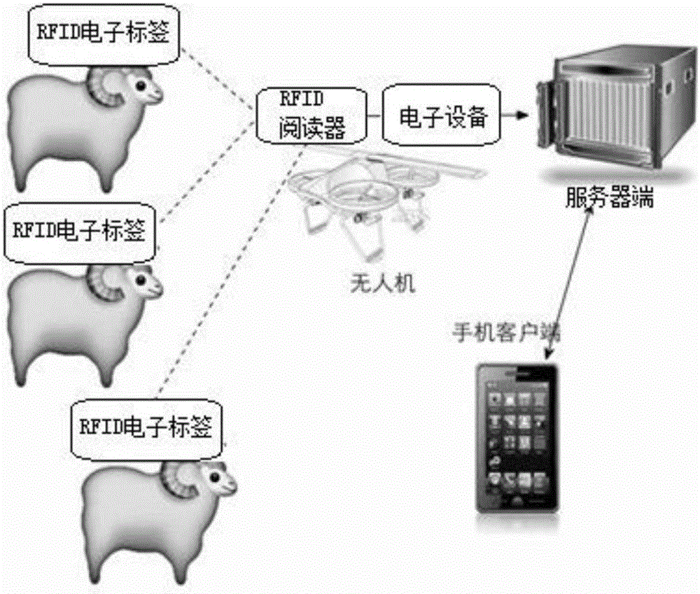
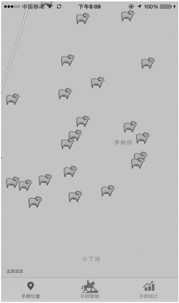
[0047] The positioning system of this embodiment includes a data collection function module for collecting the geographic location information of livestock, a data analysis and processing function module for reprocessing the data collected by the data collection function module and after preliminary processing, and a function module for users to view grazing livestock The data display function module of the geographic location point.

[0048] The RFID electronic tags, RFID readers, and drones in this embodiment are all commercially available products.

[0049] Such as figure 1 As shown, the data acquisition function module of this embodiment utilizes active RFID devices, unmanned aerial vehicles and mobile Internet technology to realize the requirements of strong battery life, small size, and low cost in the process of grazing livestock positioning. The specific hardware devices include binding The RFID electronic tag on the livestock, the RFID reader matched with the RFID el...


PUM


Abstract

The invention discloses an animal husbandry positioning system and a positioning correction method based on an unmanned plane and an RFID. The animal husbandry positioning system comprises a data collection function module for collecting livestock geographical position information data, a data analysis processing function module and a data display function module for enabling a user to check the geographical position points of livestock. Compared with an existing GPS device, the cost is lowered by 60%.

Description

technical field [0001] The invention relates to the technical field of positioning, in particular to a livestock positioning system and a positioning correction method based on drones and RFID. Background technique [0002] At present, in the vast rural areas of China, especially in the south, free-range farmers in mountainous and hilly areas will face the following problems: [0003] 1. It is difficult to locate livestock. In areas with large space and complex terrain, it is difficult to obtain the specific location of livestock. [0004] 2. Livestock are easy to lose: easy to be stolen or lost by oneself. [0005] 3. It is difficult to count the number of livestock, and it is difficult for the breeders to count the specific number of livestock. [0006] GPS devices are used to locate livestock in the market: a GPS device is bound to each livestock, and the GPS device sends its own geographical location signal to the server through the GPRS mobile data network, and the fa...

Claims


Application Information

Patent Timeline
IPC IPC(8): G01S19/14G06K17/00G06Q50/02
CPCG01S19/14G06K17/00G06Q50/02
Inventor 胡必玲叶嘉桓郭玉堂潘洁珠
Owner HEFEI NORMAL UNIV
Why Eureka
Try Eureka