GPS positioning and road matching method based on grid division

A technology of GPS positioning and grid division, which is applied to road network navigators, satellite radio beacon positioning systems, measuring devices, etc. Effect

Active Publication Date: 2016-12-14
FUJIAN UNIV OF TECH
View PDF5 Cites 35 Cited by
  • Summary
  • Abstract
  • Description
  • Claims
  • Application Information

AI Technical Summary

Problems solved by technology

The other is a search method based on a specified search radius. Usually, a minimum search radius is specified with the GPS position of the floating car as the center of the circle, and all roads that pass through this range are used as a subset of candidate matching roads. If within the specified mi...

Method used


Image

  • GPS positioning and road matching method based on grid division
  • GPS positioning and road matching method based on grid division
  • GPS positioning and road matching method based on grid division

Examples


Embodiment Construction

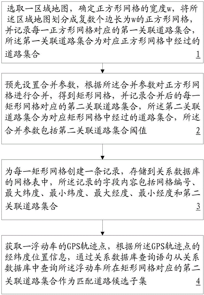
[0036] Such as Figure 1 to Figure 3 As shown, a grid-based GPS positioning and road matching method includes the following steps:

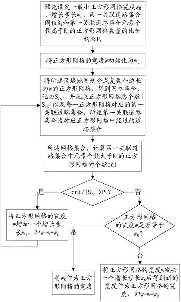
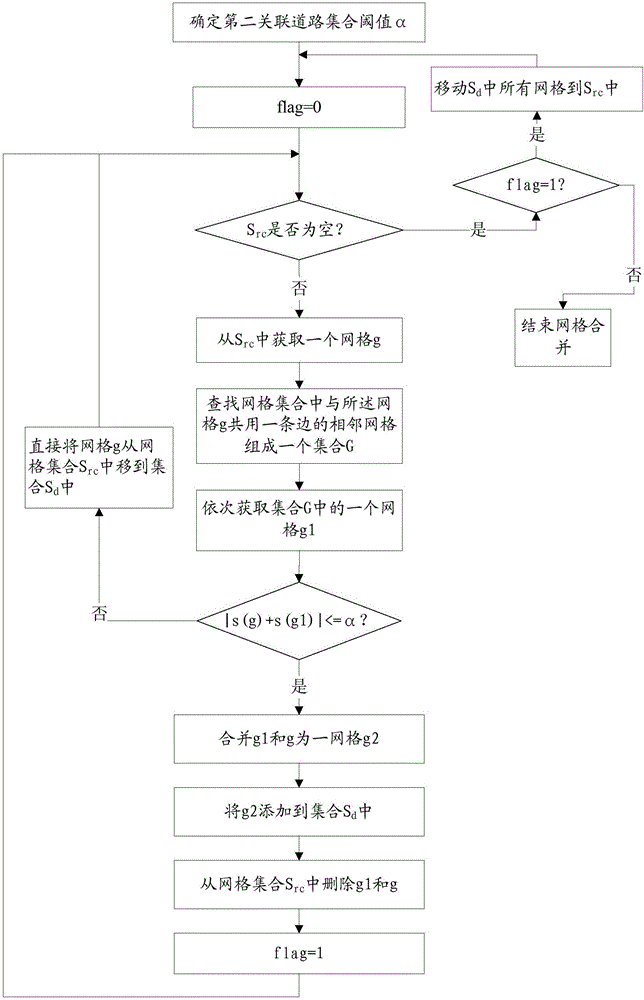
[0037] Step 1. Select an area map, determine the width w (for example, 50m) of the square grid, divide the area map into a plurality of square grids with side length w, and record the first association corresponding to each square grid A set of roads, the first set of associated roads is a set of roads passed in the corresponding square grid; wherein, the specific steps of "determining the width of the square grid" include steps a1 to a5:

[0038] Step a1, preset a minimum square grid width w 0 (for example 20m), increasing step size w s (eg 10m), the first associated road set threshold R t(eg 3) and the number of elements in the first associated road set is higher than R t The proportional constraint on the number of square grids P t (e.g. 0.01);

[0039] Step a2, initialize the width w of the square grid to w 0 ;

[0040] Step a3, divid...


PUM


Abstract

The invention provides a GPS positioning and road matching method based on grid division. The method includes the following steps that a regional map is selected, the width w of square grids is determined, the map is divided into multiple square grids with the side length being w, and a first correlation road set of each square grid is recorded; combination parameters are preset, the square grids are combined according to the combination parameters to obtain rectangular grids, and a second correlation road set of each rectangular grid is recorded; a record is created for each rectangular grid and stored in a grid table of a relational database; a relational database inquiry statement follow relation database is searched for second correlation road sets corresponding to the rectangular grids where probe vehicles are located according to longitudinal and latitude position information of GPS track points of the probe vehicles, and the second correlation road sets serve as matching road candidate subsets. The inquiry efficiency of the matching road candidate subsets is improved, the controllability of the matching road candidate subsets is achieved, and the efficiency and flexibility of road matching are improved.

Description

technical field [0001] The invention relates to the technical field of traffic information collection and processing, in particular to a grid division-based GPS positioning and road matching method. Background technique [0002] At present, a large number of operating vehicles (such as taxis, buses, etc.) are equipped with GPS positioning equipment. These vehicles are collectively called floating vehicles. On the one hand, its speed on urban roads can be extracted according to its time-related GPS trajectory, and then provide a basis for urban traffic management. [0003] Through the real-time analysis of the speed and status of a large number of floating cars in the city, the congestion situation of each road section can be estimated, so as to realize real-time adjustment of traffic control parameters, such as timing of traffic lights at each intersection to improve traffic efficiency in congested areas. In this process, it is first necessary to quickly match the GPS point...

Claims


Application Information

Patent Timeline
IPC IPC(8): G01C21/30G01S19/42
Inventor 聂作先邹复民聂明星胡蓉廖律超徐翔邓艳玲张茂林王平阳
Owner FUJIAN UNIV OF TECH
Why Eureka
Try Eureka