Method and apparatus for determining optimal route based on navigation map

A navigation map, the best technology, applied in navigation, measuring device, mapping and navigation, etc., can solve the problem of no height limit, width limit, weight limit, low degree of freedom, affecting user experience and other problems

Inactive Publication Date: 2016-12-21
BEIJING JINGDONG SHANGKE INFORMATION TECH CO LTD +1
View PDF12 Cites 12 Cited by
  • Summary
  • Abstract
  • Description
  • Claims
  • Application Information

AI Technical Summary

Problems solved by technology

Although some map navigation schemes have some selection conditions, such as avoiding congestion, avoiding tolls, not taking high speed, etc., the user's choice is still not independent and free enough.
[0004] In addition, the existing navigation solutions are only for small cars. If the user's vehicle type is SUV (Sports Utility Vehicle), MVP (Multi-Purpose Passenger Vehicle), large passenger car, etc., but the actual part of the road only allows small cars to pass, then according to Existing navigation solutions for navigation cannot provide users with the most optimal itinerary path, thus affecting the user experience
[0005] It can be seen that there are some deficiencies in the existing schemes, such as the low degree of freedom for users to choose, the route order and end point order of road sections are not determined according to the optimal route, the factors of vehicle types are not considered, and there are no height, width, and weight restrictions, etc. Defects such as information prompts

Method used


Image

  • Method and apparatus for determining optimal route based on navigation map
  • Method and apparatus for determining optimal route based on navigation map
  • Method and apparatus for determining optimal route based on navigation map

Examples


Embodiment Construction

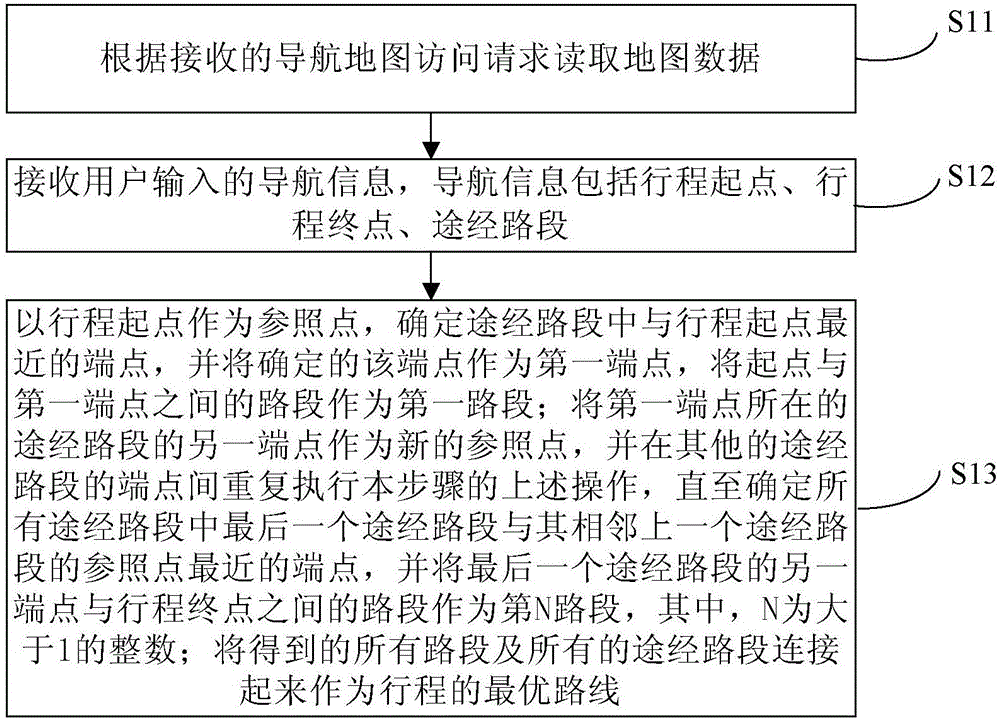
[0027] Exemplary embodiments of the present invention are described below in conjunction with the accompanying drawings, which include various details of the embodiments of the present invention to facilitate understanding, and they should be regarded as exemplary only. Accordingly, those of ordinary skill in the art will recognize that various changes and modifications of the embodiments described herein can be made without departing from the scope and spirit of the invention. Also, descriptions of well-known functions and constructions are omitted in the following description for clarity and conciseness.

[0028] figure 1 is a schematic diagram of main steps of a method for determining an optimal route based on a navigation map according to an embodiment of the present invention.

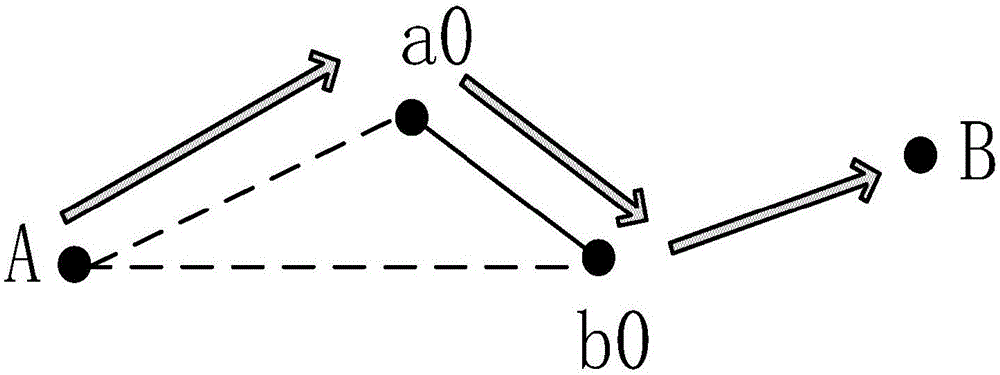
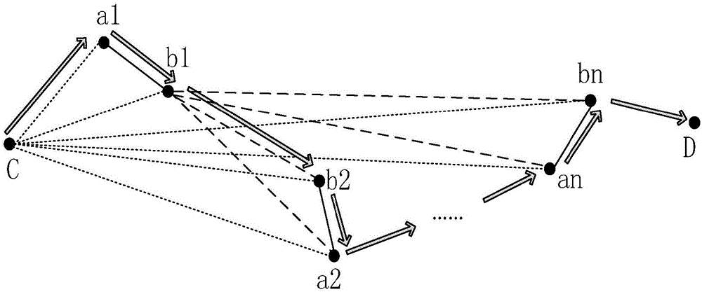
[0029] Such as figure 1 As shown, the method for determining the optimal route based on the navigation map in the embodiment of the present invention mainly includes steps S11 to S13.

[0030] ...


PUM


Abstract

The invention provides a method and an apparatus for determining the optimal route based on a navigation map. With the method and the apparatus of the present invention, the user can achieve greater freedom, the road restriction information can be prompted, the vehicle type factor can be considered, the user can select the passing-through road section end point order, and the optimal travel route can be obtained according to the user selection. The method comprises: 1, reading map data according to a navigation map access request; 2, receiving input navigation information; and 3, adopting the starting point of a travel as a reference point, determining the end point nearest to the starting point of the travel in the passing-through road section as a first end point, adopting the road section between the starting point and the first end point as a first road section, adopting another end point in the passing-through road section with the first end point existing as the new reference point, repeatedly performing the operations in the step 3 on the end points of other passing-through road sections, adopting the road section between another end point of the final passing-through road section and the ending point of the travel as the N-th road section, and connecting all the road sections and the passing-through road sections as the optimal route.

Description

technical field [0001] The invention relates to the technical field of computers and software thereof, in particular to a method and device for determining an optimal route based on a navigation map. Background technique [0002] With the development of the Global Positioning System (GPS), the emergence of various map navigations has brought great convenience to the majority of drivers. No matter whether the driver can understand the map, as long as the destination is correctly entered, the voice navigation can arrive successfully. According to real-time traffic information, some traffic jams can be avoided, and even traffic control sections can be avoided. [0003] Existing map navigation schemes mainly use real-time traffic information to set limited passing locations, and provide users with a limited route selection scheme from the start point to the end point, in which the order of the routes entered by the user and the order of the two ends of the road segment are fixe...

Claims


Application Information

Patent Timeline
Patent Type & Authority Applications(China)
IPC IPC(8): G01C21/34
CPCG01C21/3492G01C21/3453
Inventor 高伟王海旭吕艳
Owner BEIJING JINGDONG SHANGKE INFORMATION TECH CO LTD
Why Eureka
Try Eureka