Oblique three-dimensional aerial measurement data acquisition system and acquisition method and control terminal

A technology of acquisition system and control terminal, applied in three-dimensional position/channel control, non-electric variable control, control/regulation system and other directions, which can solve the problems of high technical threshold of flight operation, poor operational flexibility, and limited flight collection methods. , to achieve the effect of expanding the scope of the flight platform, reducing the cost of camera equipment, and standardizing the operation process

Inactive Publication Date: 2016-12-21
广州优飞信息科技有限公司
View PDF9 Cites 29 Cited by
  • Summary
  • Abstract
  • Description
  • Claims
  • Application Information

AI Technical Summary

Problems solved by technology

It is difficult to popularize and apply. It can only be used as professional equipment for professional units for industry services, and cannot be popularized to all surveying and mapping units.
[0012] (2) There are many equipments on the flight platform, the operation is complicated, professional flight control personnel are required, and the threshold of aviation technology is high
First, the flight platform is relatively large, and generally requires a large customized vehicle for transportation; second, in addition to the flight platform, there are many accessories such as ground stations, radio stations, and communication antennas, and the operation process is complicated; third, professional pilots are required Personnel operation, high technical threshold for flight operation
[0014] (3) The operation flexibility is poor, and it is greatly affecte...

Method used


Image

  • Oblique three-dimensional aerial measurement data acquisition system and acquisition method and control terminal
  • Oblique three-dimensional aerial measurement data acquisition system and acquisition method and control terminal
  • Oblique three-dimensional aerial measurement data acquisition system and acquisition method and control terminal

Examples


Embodiment Construction

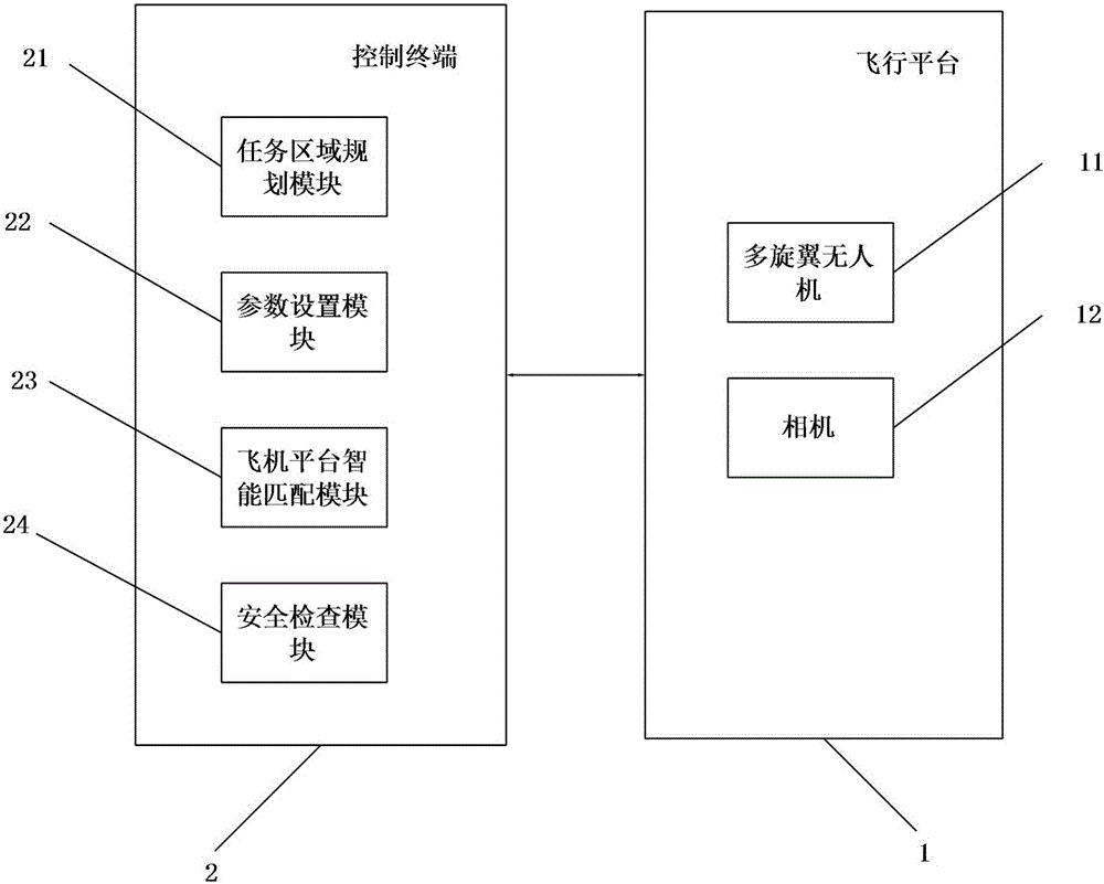
[0070] see image 3 , which is a schematic diagram of the three-dimensional aerial survey data acquisition system of the present invention. The invention provides a three-dimensional aerial survey data collection system, which includes a flight platform 1 and a control terminal 2 .

[0071] The flying platform 1 includes a multi-rotor drone 11 and a single camera 12 mounted on the multi-rotor drone.

[0072] The control terminal 2 includes: a mission area planning module 21 , a parameter setting module 22 , an aircraft platform intelligent matching module 23 and a safety inspection module 24 .

[0073] The mission area planning module 21 is used for planning flight routes.

[0074] The parameter setting module 22 is used to set the flight parameters of the multi-rotor UAV, including the starting position, the end position, the tilt angle of the nose, the flying height of the aircraft, the degree of heading overlap and the degree of lateral overlap. Specifically, the paramet...


PUM


Abstract

The invention relates to an oblique three-dimensional aerial measurement data acquisition system, which comprises a flight platform and the control terminal. The flight platform comprises a multi-rotor unmanned aerial vehicle and a single camera arranged on the multi-rotor unmanned aerial vehicle. The control terminal comprises a task area planning module for planning the flight course; and a parameter setting module for setting flight parameters of the multi-rotor unmanned aerial vehicle, the flight parameters comprising start point position, final point position, inclination angle of a nose, airplane flying height, forward overlap degree and side overlap degree. The multi-rotor unmanned aerial vehicle flies according to the planned number of flight, the flight course and the set parameters. The camera is used for collecting data in the flying process. The invention also provides a data acquisition method and the control terminal. Compared with the prior art, the brand-new flight data acquisition method is designed to adapt to a single-lens, multi-rotor and individual oblique photograph acquisition work mode; furthermore, full-automatic flight acquisition is realized, and operation process is normalized; and achievement quality is ensured and work efficiency is improved.

Description

technical field [0001] The invention relates to the field of unmanned aerial vehicle control, in particular to an acquisition system, acquisition method and control terminal for three-dimensional aerial survey data. Background technique [0002] The world is three-dimensional. With the development of computer, surveying and mapping, and geographic information technology, people are increasingly demanding to see the world from a three-dimensional perspective. The advantages of true three-dimensional digital city construction are gradually becoming prominent, and it has become the mainstream of smart city information construction all over the world. Oblique photography technology is a high-tech developed in the field of international surveying and mapping in recent years. It subverts the limitation that orthophotos can only be taken from vertical angles in the past. By carrying multiple sensors on the same flight platform, and simultaneously collecting images from five differ...

Claims


Application Information

Patent Timeline
IPC IPC(8): G05D1/10H04N5/232
CPCG05D1/101H04N23/66H04N23/69
Inventor 罗志勇熊勇良
Owner 广州优飞信息科技有限公司
Why Eureka
Try Eureka