
A Method for Mosaic of Aerial Image Mosaic by Mosaic Lines from Vector Housing Data

A technology of aerial images and mosaic lines, applied in image data processing, image enhancement, graphics and image conversion, etc., can solve problems such as vector house data application, achieve the effect of improving mosaic efficiency, high efficiency, and saving computing time

Active Publication Date: 2019-03-15
INST OF GEOGRAPHICAL SCI & NATURAL RESOURCE RES CAS
View PDF4 Cites 0 Cited by
  • Summary
  • Abstract
  • Description
  • Claims
  • Application Information

AI Technical Summary

Problems solved by technology

However, so far, few scholars have studied how to apply vector house data to aerial image mosaic, and the efficiency and effect of applying it to image mosaic

Method used


Image

  • A Method for Mosaic of Aerial Image Mosaic by Mosaic Lines from Vector Housing Data
  • A Method for Mosaic of Aerial Image Mosaic by Mosaic Lines from Vector Housing Data
  • A Method for Mosaic of Aerial Image Mosaic by Mosaic Lines from Vector Housing Data

Examples


Embodiment Construction

[0043] The technical solution of the present invention will be further described below in conjunction with the accompanying drawings.

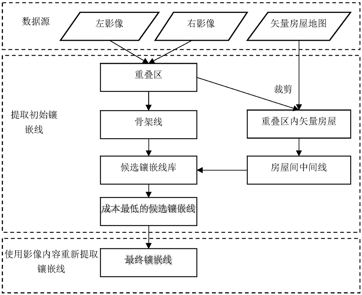
[0044] as attached figure 1 Show, a kind of method that selects mosaic line pair aerial image mosaic from vector housing data, it is characterized in that, comprises the following steps:

[0045] 1) Based on the left-turn algorithm, extract the boundary line of the effective area for each image in each air strip of the captured aerial image, and the effective area refers to the non-null area in the image. In each flight zone, calculate the overlapping area of ​​adjacent images in the flight zone according to the boundary line of the effective area of ​​each image in the flight zone;

[0046] 2) Merge the valid areas in each flight belt to obtain the boundary line of the effective area of ​​each flight belt, and calculate the overlapping area of ​​adjacent flight belts between the flight belts according to the obtained boundary line of the eff...


PUM


Abstract

The invention provides a method for aviation image mosaic by selecting mosaic lines from vector building data. The method is characterized by comprising the following steps that 1) an overlap area of adjacent images within each air strip is calculated according to boundaries of an effective area of each image in the air strip; 2) an overlap area of adjacent air strips among the air strips is calculated according to the obtained boundaries of the effective area of each air strip; 3) on the basis of existing vector building data, mosaic lines are searched from the overlap areas of the adjacent images in the air strips and the overlap areas of the adjacent air strips among the air strips; 4) all the mosaic lines in and among the air strips are cut mutually, and effective mosaic polygons are constructed for the images respectively; and 5) data in the effective mosaic polygon of each image is merged to form a final mosaic image which includes all the single images. According to the method for aviation image mosaic, the vector data is used to construct the initial mosaic polygons, grid images themselves are used for local optimization, time for constructing the mosaic polygons can be shortened, crossing protruded objects as buildings can be avoided, and the amount of post manual editing is reduced substantially.

Description

technical field [0001] The invention relates to the technical field of aerial image processing, in particular to a method for selecting mosaic lines from vector house data to mosaic aerial images. Background technique [0002] The "National Medium- and Long-Term Science and Technology Development Plan (2006-2020)" clearly lists the development of high-resolution earth observation systems (referred to as "high-resolution special projects") as one of the 16 major special projects. Around 2020, the system will be fully completed and put into use, which will significantly improve my country's all-weather, all-time, global coverage of the earth observation capabilities. However, with the resolution of remote sensing images getting higher and higher, the application of remote sensing data in various industries has become more and more extensive, and the amount of remote sensing image data covering a given area (such as Wuhan City) has shown explosive growth. The initial GB order ...

Claims


Application Information

Patent Timeline
Patent Type & Authority Patents(China)
IPC IPC(8): G06T3/40G06T5/50
CPCG06T3/4038G06T5/50
Inventor 王东亮
Owner INST OF GEOGRAPHICAL SCI & NATURAL RESOURCE RES CAS
Learn More