Road network-based spatio-temporal trajectory clustering method
A technology of spatio-temporal trajectory and clustering method, applied in the fields of structured data retrieval, instruments, electronic digital data processing, etc. The effect of storage space and large application prospects
- Summary
- Abstract
- Description
- Claims
- Application Information
AI Technical Summary
Problems solved by technology
Method used
Image
Examples
Embodiment Construction
[0077] The technical solution of the present invention will be further described in detail below in conjunction with the accompanying drawings, but the protection scope of the present invention is not limited to the following description.
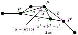
[0078] Such as figure 1 For the system block diagram of the present invention, first set up the space-time trajectory model:
[0079] Definition 1 coordinate point: a coordinate point with a time stamp is defined as P=(Lat, Lngt, T), where Lat is the latitude, Lngt is the longitude, and T is the time stamp.
[0080] Definition 2 GPS trajectory: A GPS trajectory Tra is defined as a set of coordinate point sequences composed of time series, Tra=P1->P2->...~pn, where pi.T<pi+1.T.
[0081] Definition 3 Stay point Chuan: given time threshold θ t and the distance threshold θ d , the stay point s is defined as a continuous coordinate point P=(P m ,P m+1 ,...,P n ),in:
[0082] ∀ m i ≤ n , ...
PUM
 Abstract
Description
Claims
Application Information
 - R&D
- Intellectual Property
- Life Sciences
- Materials
- Tech Scout
- Unparalleled Data Quality
- Higher Quality Content
- 60% Fewer Hallucinations
Browse by: Latest US Patents, China's latest patents, Technical Efficacy Thesaurus, Application Domain, Technology Topic, Popular Technical Reports.
© 2025 PatSnap. All rights reserved.Legal|Privacy policy|Modern Slavery Act Transparency Statement|Sitemap|About US| Contact US: help@patsnap.com


