County remote-sensing scale-oriented crop planting area information extraction method and device

A technology of information extraction and crops, applied in data processing applications, instruments, calculations, etc., can solve problems such as insufficient spectral information of a single image, difficulty in distinguishing different crop types, and "salt and pepper" effect in classification results, etc., to achieve Improve the accuracy of ground object recognition, improve the accuracy of planting area information extraction, and enrich the effect of spectral information

Inactive Publication Date: 2017-02-22
SPACE STAR TECH CO LTD
View PDF4 Cites 17 Cited by
  • Summary
  • Abstract
  • Description
  • Claims
  • Application Information

AI Technical Summary

Problems solved by technology

Comparing and analyzing the two types of classification algorithms, the pixel-based supervised classification algorithm, the classification results are prone to "salt and pepper" effect; while the object-oriented classification based on the plot scale can eliminate the "salt and pepper" effect to a large extent, but it is affected by a single image Influenced by the lack of rich spectral information, it is difficult to distinguish different crop types at the same time

Method used


Image

  • County remote-sensing scale-oriented crop planting area information extraction method and device
  • County remote-sensing scale-oriented crop planting area information extraction method and device
  • County remote-sensing scale-oriented crop planting area information extraction method and device

Examples


Embodiment 2

[0181] Figure 8 It is a schematic diagram of a crop planting area information extraction device oriented to the county remote sensing scale using any of the crop planting area information extraction methods disclosed in the present invention. The device includes:

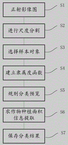
[0182] An orthophoto module 10, configured to prepare an orthophoto map after orthocorrection processing;

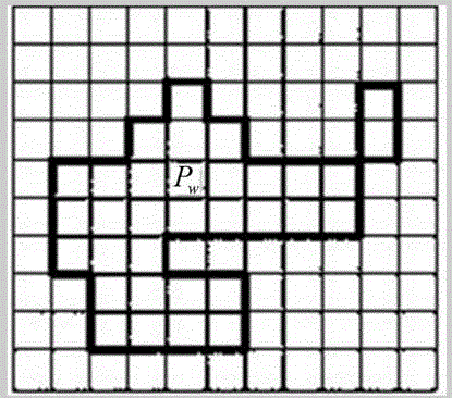
[0183] The scale segmentation module 20 is used to set the segmentation scale parameters according to the texture and shape features of the ground objects, and select the best segmentation scale for scale segmentation, so that the divided plots have the same ground feature attributes;

[0184] Sample selection module 30, used to select typical representative plots as sample objects;

[0185] The membership function building module 40 is used to set up the membership function, including at least a vegetation index feature function, a texture feature function, and a shape feature function;

[0186] Classifica...


PUM


Abstract

The invention discloses a county remote-sensing scale-oriented crop planting area information extraction method and device. The method comprises the following steps: preparing an orthophoto map subjected to ortho-rectification; setting segmentation scale parameters according to terrain texture and shape features, and selecting the optimal segmentation scale for performing scale segmentation, so that the segmented plot has the same terrain object attribute; selecting a plot with a typical example as a sample object; establishing a subordinating degree function comprising a vegetation index feature function, a texture feature function and a shape feature function at least; performing rule classification review; extracting the crop planting area information; saving classification results. According to the method and device disclosed by the invention, the crop information extraction accuracy and efficiency can be improved.

Description

technical field [0001] The invention relates to the field of quantitative remote sensing image information extraction, and specifically relates to a method and device for extracting crop planting area information on a county-level remote sensing scale. Background technique [0002] Food security is the main challenge facing mankind in the 21st century. The global population will exceed 9 billion by 2050. How to ensure food supply for 9 billion people, agriculture will face unprecedented pressure in the next 40 years. [0003] As the most benchmark statistical unit for crop statistics of the National Bureau of Statistics, the county area accurately grasps the quantity of food crops, especially its spatial location distribution information, which is related to national food security and can be used for agricultural production, output estimation, food price forecast and national food production. Production layout and planning provide an important scientific basis. [0004] Th...

Claims


Application Information

Patent Timeline
Patent Type & Authority Applications(China)
IPC IPC(8): G06K9/00G06K9/54G06Q50/02
CPCG06Q50/02G06V20/188G06V10/20
Inventor 高涛李志鹏郭会敏丁火平
Owner SPACE STAR TECH CO LTD
Why Eureka
Try Eureka