Method and system for acquiring electric power GIS data
A technology for obtaining electricity and data, which is applied in the field of obtaining electric power GIS data, can solve problems such as time-consuming and labor-consuming, reduce the work efficiency of designers, and combine GIS data, so as to achieve the effect of improving work efficiency
- Summary
- Abstract
- Description
- Claims
- Application Information
AI Technical Summary
Problems solved by technology
Method used
Image

Examples
Embodiment 1
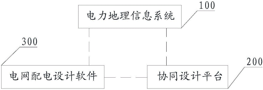
[0072] Please refer to figure 1 , Embodiment 1 of the present invention is: a method for obtaining power GIS data, this method is based on such as figure 2 The architecture shown includes a power geographic information system 100 (electric power GIS), a collaborative design platform 200 and power grid distribution design software 300, and the collaborative design platform 200 is respectively connected to the power geographic information system 100 and power grid power distribution design software 300 , the power geographic information system 100 is connected to the grid power distribution design software 300 . Preferably, the grid power distribution design software 300 may be AutoCAD.
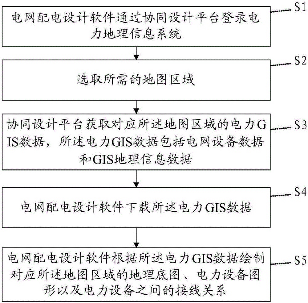
[0073] The method comprises the steps of:
[0074] S1: Power grid distribution design software logs into the power geographic information system through the collaborative design platform.
[0075] S2: Select the required map area. Further, the power GIS data corresponding to the map area i...
Embodiment 2
[0081] This embodiment is a further extension of steps S1 and S2 in the first embodiment.
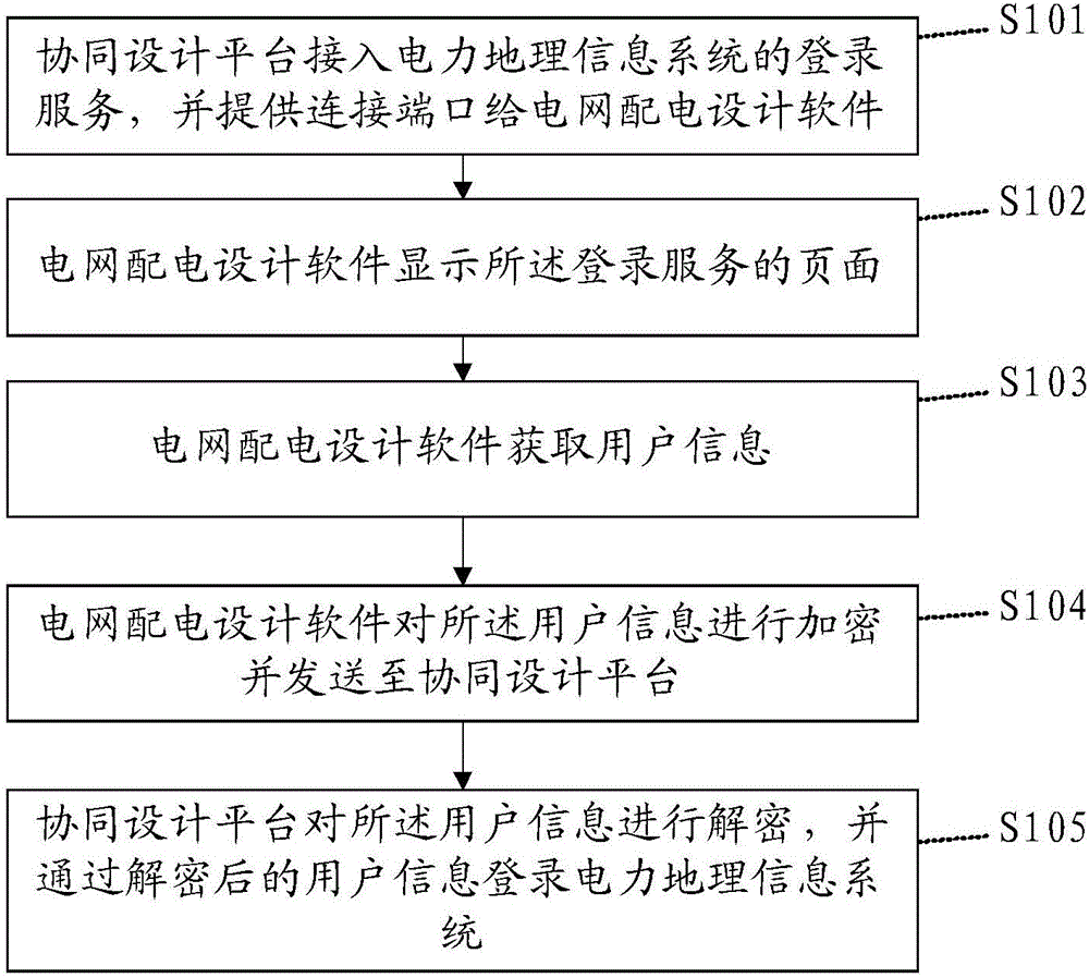
[0082] Please refer to image 3 , step S1 includes the following steps:
[0083] S101: The collaborative design platform accesses the login service of the power geographic information system, and provides a connection port to the power grid distribution design software.
[0084] S102: The power grid distribution design software displays the login service page; that is, connects to the power geographic information system through the connection port, and obtains the login service page, which is embedded in the grid power distribution design software.
[0085] S103: The power grid distribution design software acquires user information; for example, account password.
[0086] S104: The power grid distribution design software encrypts the user information and sends it to the collaborative design platform.
[0087] S105: The collaborative design platform decrypts the user information, and ...
Embodiment 3
[0095] This embodiment is a specific application scenario of the foregoing embodiments.
[0096] The designer opens the design software and enters user information on the login service page. The design software encrypts the user information and sends it to the collaborative design platform. The collaborative design platform receives the encrypted user information transmitted by the design software and logs in to the power geography after analysis. Information system; select a rectangular map area on the interface of the electric power geographic information system, record the coordinates of the selected area, and transmit the coordinate information to the electric power geographic information system, call the interface to obtain the power grid equipment data and geographic information data; the collaborative design platform receives the data, and Package the data into a file and store it in the server; encrypt the storage location information, and pass the encrypted storage loc...
PUM
 Abstract
Description
Claims
Application Information
 - R&D
- Intellectual Property
- Life Sciences
- Materials
- Tech Scout
- Unparalleled Data Quality
- Higher Quality Content
- 60% Fewer Hallucinations
Browse by: Latest US Patents, China's latest patents, Technical Efficacy Thesaurus, Application Domain, Technology Topic, Popular Technical Reports.
© 2025 PatSnap. All rights reserved.Legal|Privacy policy|Modern Slavery Act Transparency Statement|Sitemap|About US| Contact US: help@patsnap.com