Geographic-information-based comprehensive pipeline data two-dimensional and three-dimensional integrated organization method

A technology that integrates pipelines and geographic information, applied in the field of data organization, can solve problems such as slow modeling speed, expensive manual intervention, and weak precise positioning of pipeline elements

Inactive Publication Date: 2017-04-26
星际空间(天津)科技发展有限公司
View PDF3 Cites 15 Cited by
  • Summary
  • Abstract
  • Description
  • Claims
  • Application Information

AI Technical Summary

Problems solved by technology

The three-dimensional modeling of the pipe network is carried out through the three-dimensional modeling software. This modeling method first needs to import the central axis of the pipe network entity into the computer-aided design software, and then use the human-computer interaction technology to render the points and lines in the three-dimensional software. The method generates a 3D model of the pipeline and performs corresponding processing on the pipelin

Method used


Image

  • Geographic-information-based comprehensive pipeline data two-dimensional and three-dimensional integrated organization method
  • Geographic-information-based comprehensive pipeline data two-dimensional and three-dimensional integrated organization method
  • Geographic-information-based comprehensive pipeline data two-dimensional and three-dimensional integrated organization method

Examples


Embodiment 1

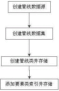
[0088] figure 1 It is a schematic flow chart of a 2D and 3D integrated organization method for comprehensive pipeline data based on geographic information provided in this embodiment. Such as figure 1 As shown, a 2D and 3D integrated organization method for comprehensive pipeline data based on geographic information includes the following steps:

[0089] Create pipeline data sources: Create pipeline data sources according to pipeline standards, and organize the information in pipeline data sources;

[0090] Create a pipeline dataset: create a pipeline dataset to store pipeline classes; create a spatial reference, and determine the spatial coordinates of the pipeline point elements according to the spatial reference coordinate system;

[0091] Create and store pipeline classes: create a pipeline class consisting of pipeline point feature classes and pipeline line feature classes based on pipeline type, pipeline point layer information, and pipeline line layer information, and...


PUM


Abstract

The invention, which relates to the technical field of data organization, discloses a geographic-information-based comprehensive pipeline data two-dimensional and three-dimensional integrated organization method. The method comprises steps of establishing a pipeline data source, establishing a pipeline data set, establishing a pipe line type and carrying out storage, and adding an element type index and carrying out storage. With the method provided by the invention, technical problems of geographic-information-based two-dimensional and three-dimensional integrated management of underground pipe network data and spatial data organization, retrieving, and analysis can be solved effectively. Inquiring and rendering of pipeline elements can be realized conveniently by organized processing on pipe points and pipelines in an underground pipe network; the access efficiency of pipe network information in a three-dimensional scene can be improved; and the unified display, management and analysis level of a plurality of underground pipe network systems with different attribute can be enhanced. An important basis is provided for obtaining and construction plans of underground pipe network spatial information in smart city building and large-scale development and utilization of urban underground spatial resources can be promoted during rapid development of urban construction.

Description

technical field [0001] The invention relates to the technical field of data organization, in particular to a technical problem that can effectively solve the two-dimensional and three-dimensional integrated management of underground pipe network data based on geographical information, spatial data organization, retrieval and analysis, and the like. By organizing the pipe points and pipelines in the underground pipe network to facilitate the query and rendering of pipeline elements, the access efficiency to the pipe network information in the 3D scene is improved, and the unification of multiple underground pipe network systems with different attributes is improved. A 2D and 3D integrated organization method of comprehensive pipeline data based on geographic information for display, management and analysis levels. Background technique [0002] Urban underground space is a huge and abundant space resource, and the amount of resource that can be developed in urban underground s...

Claims


Application Information

Patent Timeline
IPC IPC(8): G06Q50/08G06F17/30
Inventor 沈迎志沈美岑高健蔡红鲍佳欢董肖陈玉成
Owner 星际空间(天津)科技发展有限公司
Why Eureka
Try Eureka