A Downscaling Correction Method for Satellite Precipitation Data
What is AI technical title?
AI technical title is built by PatSnap AI team. It summarizes the technical point description of the patent document.
A correction method and downscaling technology, applied in the field of satellite measurement of precipitation data processing, can solve problems such as low resolution of satellite precipitation data
Active Publication Date: 2020-05-05
HOHAI UNIV
View PDF6 Cites 0 Cited by
Summary
Abstract
Description
Claims
Application Information
AI Technical Summary
This helps you quickly interpret patents by identifying the three key elements:
Problems solved by technology
Method used
Benefits of technology
Problems solved by technology
[0005] The purpose of the present invention is to solve the problem of low resolution of satellite precipitation data in the prior art; to provide a downscaling correction method for satellite precipitation data
Method used
Image
Click on the blue label to locate the original text in one second.
Reading with bidirectional positioning of images and text.
Examples
Embodiment 1
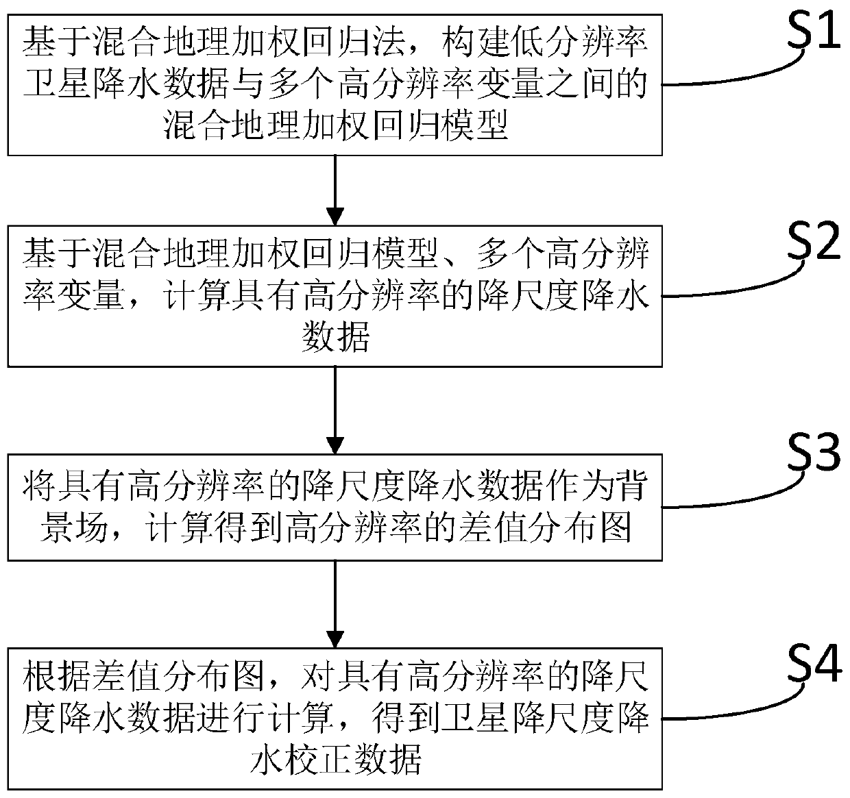
[0032] Such as figure 1 As shown, a downscaling correction method for satellite precipitation data, the method includes:
[0033] S1, based on the hybrid geographic weighted regression method, construct a hybrid geographic weighted regression model between low-resolution satellite precipitation data and multiple high-resolution variables. Multiple high-resolution variables are: annual normalized difference vegetation index, surface temperature, elevation, slope, aspect, longitude, and latitude.
[0034] In the present invention, the spatial resolution range of the low resolution is 10-30km; the spatial resolution range of the high resolution is 0.5-4km. In this embodiment, the low resolution is a spatial resolution of 27 km; the high resolution is a spatial resolution of 1 km.
[0035] S2, based on a mixed geographically weighted regression model and multiple high-resolution variables, calculate downscaled precipitation data with high resolution.
[0036] S3, the high-resol...
Embodiment 2
[0040] Such as figure 1As shown, a downscaling correction method for satellite precipitation data, the method includes:
[0041] S1, based on the hybrid geographic weighted regression method, construct a hybrid geographic weighted regression model between low-resolution satellite precipitation data and multiple high-resolution variables. Multiple high-resolution variables are: annual normalized difference vegetation index (Normalized Difference Vegetation Index, NDVI for short), surface temperature, elevation, slope, aspect, longitude, and latitude.
[0042] In this embodiment, all low-resolution satellite precipitation data of a certain year are accumulated and calculated to obtain annual-scale low-resolution satellite precipitation data.
[0043] In the present invention, the spatial resolution range of the low resolution is 10-30km; the spatial resolution range of the high resolution is 0.5-4km. In this embodiment, the low resolution is a spatial resolution of 27 km; the ...
PUM
Abstract
The invention discloses a downscaling compensation technique for satelliteprecipitation data. Firstly, based on a mixed geographically weighted regression method, a mixed geographically weighted regression between low resolutionsatelliteprecipitation data and multiple high resolution variables is constructed. Secondly, based on the mixed geographically weighted regression and multiple high resolution variables, the downscalingprecipitation data with high resolution is calculated. Thirdly, regarding the downscaling precipitation data with high resolution as an ambient field, a difference value distribution diagram with high resolution is acquired by calculating. Lastly, according to the difference value distribution diagram, the downscaling precipitation data with high resolution is calculated and the satellite downscaling precipitation compensation data is acquired. The downscaling compensation technique for satellite precipitation data is capable of obtaining high-precision satellite precipitation data with high resolution and being applied to the calculation of meteorological drought index and a driving hydrological model and providing high-precision input data for the hydrological model.
Description
technical field [0001] The invention relates to satellite-measured precipitation data processing technology, in particular to a downscale correction method acting on satellite precipitation data. Background technique [0002] Precipitation is a key climate element in the global water and energy cycle. The occurrence of precipitation is affected by many factors and has strong temporal and spatial changes. Before the advent of meteorological satellites, the measurement of rainfall was mainly done by ground-based rain gauges. The rain gauge measurement method has high accuracy for a single point, but it cannot reflect the precipitation distribution on a large spatial scale. Since the advent of meteorological satellites in the 1960s, the use of remote sensing to track and analyze weather systems at various scales and estimate precipitation has been greatly developed. Due to its wide coverage and relatively continuous observations in time and space, it can supplement the preci...
Claims
Application Information
Patent Timeline
Application Date:The date an application was filed.
Publication Date:The date a patent or application was officially published.
First Publication Date:The earliest publication date of a patent with the same application number.
Issue Date:Publication date of the patent grant document.
PCT Entry Date:The Entry date of PCT National Phase.
Estimated Expiry Date:The statutory expiry date of a patent right according to the Patent Law, and it is the longest term of protection that the patent right can achieve without the termination of the patent right due to other reasons(Term extension factor has been taken into account ).
Invalid Date:Actual expiry date is based on effective date or publication date of legal transaction data of invalid patent.

