Remote sensing image road network automatic extraction method with navigation data assistance

A technology of remote sensing images and navigation data, which is applied in the direction of instruments, calculations, character and pattern recognition, etc., and can solve problems such as difficult to accurately identify road objects and automatic road extraction tasks

Inactive Publication Date: 2017-05-31
WUHAN UNIV
View PDF7 Cites 60 Cited by
  • Summary
  • Abstract
  • Description
  • Claims
  • Application Information

AI Technical Summary

Problems solved by technology

On the other hand, roads are represented as a collection of various ground objects, such as vehicles, road signs, street lines, street trees, etc., which makes the internal characteristics of road elements have great heterogeneity. Large feature correlation, which makes it difficult for automatic road extraction methods to accurately identify road objects; in addition, due to shadows and other occlusions, automated road extraction tasks become more difficult

Method used


Image

  • Remote sensing image road network automatic extraction method with navigation data assistance
  • Remote sensing image road network automatic extraction method with navigation data assistance
  • Remote sensing image road network automatic extraction method with navigation data assistance

Examples


Embodiment Construction

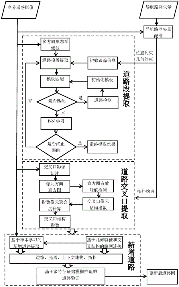
[0067] The present invention will be further described below in conjunction with specific examples and accompanying drawings.

[0068] The invention provides a method for automatically extracting road networks from remote sensing images assisted by navigation data, comprising the following steps:

[0069] S1. Registration of navigation data and remote sensing images:

[0070] According to the remote sensing image range, the OpenStreetMap navigation data is cut to obtain the vector data of the navigation road network, and the vector data is superimposed on the remote sensing image. When the position deviation between the remote sensing image and the vector data exceeds the preset deviation threshold, a number of Points of the same name to perform an overall affine transformation on the vector data. The deviation threshold is the buffer radius of the road extraction, buffer radius, etc. = road half width + registration error, and the registration error is a preset value.

[00...


PUM


Abstract

The invention provides a remote sensing image road network automatic extraction method with navigation data assistance. The method comprises the steps that registration of navigation data and a remote sensing image is performed; vector data is utilized to extract road sections; intersection pixel structure indexes are utilized to extract road intersections; a road network is extracted based on adaptive cluster learning; the extracted road sections and road intersections are connected to form the road network, and a newly-added road object in the remote sensing image is detected according to known road characteristics; and last, the road is verified. According to the method, the remote sensing image and the navigation road network data are adopted as input data sources, location, geometrical, topological and semantic information in the navigation road network data and scene characteristics in the high-resolution remote sensing image are comprehensively utilized, and the task of automatic road network element data extraction is completed in combination with realistic road structure priori knowledge, etc. The method has high practicability and high accuracy.

Description

technical field [0001] The invention relates to the technical field of remote sensing image applications, in particular to a method for automatically extracting road networks from remote sensing images aided by navigation data. Background technique [0002] With the advancement of my country's urbanization process and the rapid development of economic construction, the rapid update of road network data has become more and more important for the public and industry applications. The rapid acquisition and update of road element data has become the basis of my country's basic geographic information construction. important task. At present, the comprehensive internal adjustment based on high-resolution remote sensing images is the main method for updating basic geographic elements including road networks. There are great advantages to doing basic geographic information updates. Compared with the update of actual ground measurement data in the field, the office judgment and mapp...

Claims


Application Information

Patent Timeline
Patent Type & Authority Applications(China)
IPC IPC(8): G06K9/00G06K9/62
CPCG06V20/182G06F18/23213
Inventor 眭海刚陈光冯文卿程效猛涂继辉
Owner WUHAN UNIV
Why Eureka
Try Eureka