A Navigation and Positioning Method Using GNSS Single-satellite Signals

A navigation positioning and signal technology, which is applied in the field of satellite navigation, can solve the problems of positioning function failure, etc., and achieve the effect of high positioning accuracy, good real-time performance, and fewer GNSS satellites

Active Publication Date: 2019-03-12
XIAN INSTITUE OF SPACE RADIO TECH
View PDF4 Cites 0 Cited by
  • Summary
  • Abstract
  • Description
  • Claims
  • Application Information

AI Technical Summary

Problems solved by technology

In addition, when the GNSS receiver on the ground is located in multi-path and multi-occlusion environments such as cities, mountains, valleys, canyons, and dense forests, its positioning function will fail because it cannot receive more than four GNSS satellite signals at the same time.

Method used


Image

  • A Navigation and Positioning Method Using GNSS Single-satellite Signals
  • A Navigation and Positioning Method Using GNSS Single-satellite Signals
  • A Navigation and Positioning Method Using GNSS Single-satellite Signals

Examples


Embodiment Construction

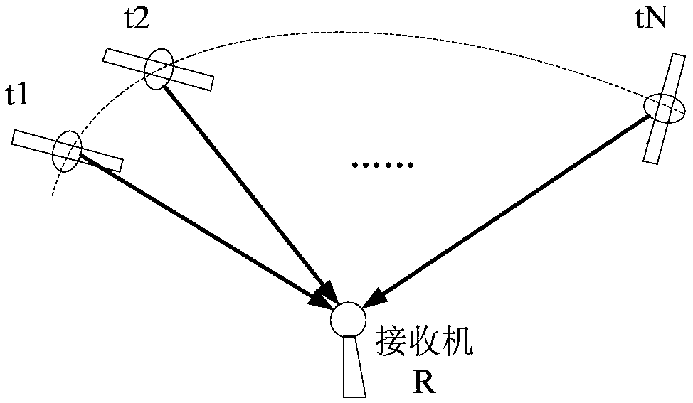
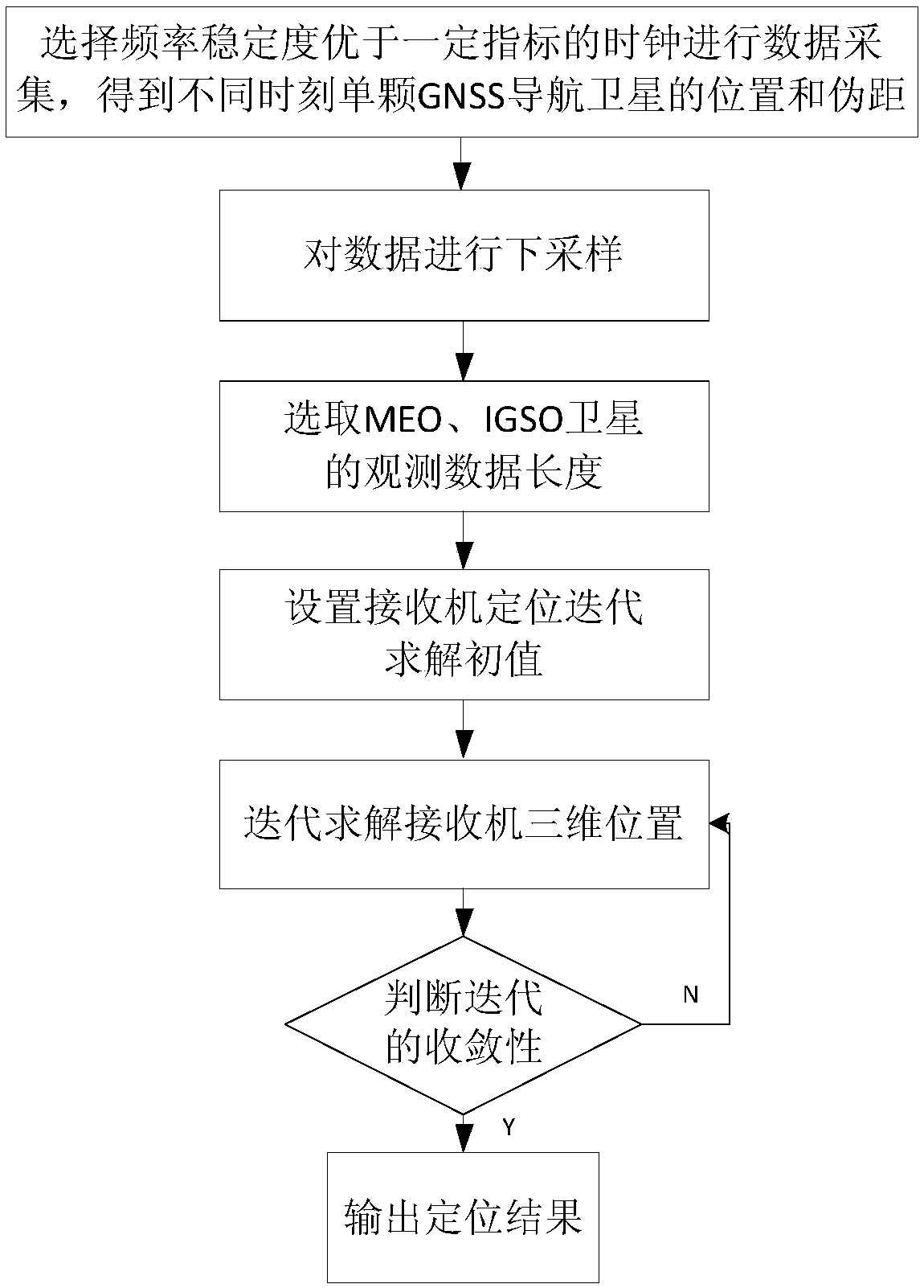
[0047] Step 1. Select a clock whose frequency stability is better than the preset index for data collection, and obtain the position and pseudorange of a single GNSS navigation satellite at different times. The receiver clock error used in this embodiment is as follows Figure 4As shown in (a), the clock stability calculated from the clock difference is as follows Figure 4 (b) shown. Depend on Figure 4 (b) It can be obtained that the frequency stability index that the receiver of this embodiment needs to satisfy is: the Allen standard deviation is better than 2.42×10 in 1s -11 , 100s better than 1.24×10 -11 , 1000s better than 2.93×10 -12 .

[0048] Let Ω x,y,z and Ω ρ respectively t 1 to t N The coordinate set and pseudorange set of GNSS navigation satellites can be observed at any time, and record t according to formula (1) and formula (2) i ,i=1,2,...t N The positions and pseudoranges of all visible GNSS navigation satellites at all times;

[0049]

[0050]...


PUM


Abstract

The invention relates to a navigation and positioning method utilizing a GNSS(Global Navigation Satellite System) single satellite signals. First, a clock with better frequency stability than a certain index is selected to acquire and collect data and position, and pseudorange of the single GNSS navigation satellite at different time are obtained; secondly, the data is sampled and the length of observation data of MEO(Medium Earth Orbit) or IGSO(inclined Geosynchronous Satellite Orbit) satellite used for navigation position resolution is selected; finally, the position of a receiver is calculated by iterative solution and the positioning results are output. The navigation and positioning method overcomes the shortcoming that the GNSS navigation and positioning method can not be used in less than four observation satellites, and realizes the high precision navigation and positioning by observing single satellite GNSS signals. The navigation and positioning method has the advantages that fewer GNSS satellites need to be observed and the positioning accuracy is high, the problem of navigation and positioning of lunar receiver only when measuring a GNSS satellite signal is solved; meanwhile, the navigation and positioning of the receiver in multi-path and multi-blocking environment on the earth is realized.

Description

technical field [0001] The invention belongs to the technical field of satellite navigation, and relates to a navigation and positioning method using GNSS single-satellite signals. Background technique [0002] In the project task of "Development of Lunar Navigation Signal Receiver Engineering Prototype", the lunar probe needs to locate its own position on the surface of the moon. However, the moon is far away from the earth, and the lunar receiver cannot effectively capture and track GNSS signals. Therefore, It cannot realize its own navigation and positioning by receiving signals from more than four GNSS navigation satellites. The navigation and positioning of the lunar receiver itself is one of the urgent problems to be solved in the lunar exploration project. In the 863 project task of "based on XX single-satellite navigation and positioning technology", in order to meet the task requirements of emergency response single-satellite navigation and positioning, it is neces...

Claims


Application Information

Patent Timeline
Patent Type & Authority Patents(China)
IPC IPC(8): G01S19/37G01S19/42
CPCG01S19/37G01S19/42
Inventor 雷文英边朗郝博吴国春蒙艳松
Owner XIAN INSTITUE OF SPACE RADIO TECH
Why Eureka
Try Eureka