GIS dynamic evaluation-based targeted poverty alleviation system
A GIS server and precise technology, applied in the application system field of urban digital management, can solve the problems of inaccurate orientation, unclear number of poor residents, crowding, etc., and achieve the effect of improving management ability and optimizing the allocation of poverty alleviation resources.
- Summary
- Abstract
- Description
- Claims
- Application Information
AI Technical Summary
Problems solved by technology
Method used
Image
Examples
Embodiment Construction
[0023] The present invention will be further described below in conjunction with the accompanying drawings.
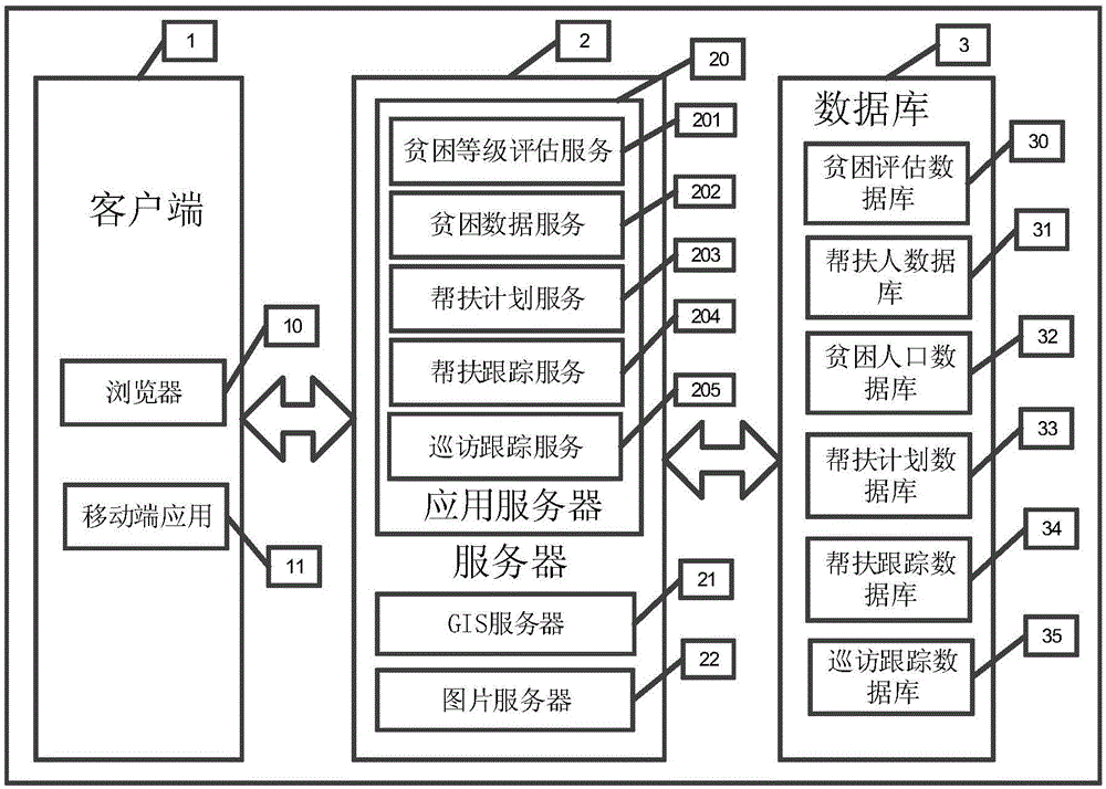
[0024] Such as figure 1 Shown is a schematic diagram of the overall structure of the precise poverty alleviation system based on GIS dynamic evaluation. Including client 1, server 2 and database 3, the server includes an application server 20, a GIS server 21 capable of providing digital map services and a picture server 22 with a picture storage function, the client 1 sends a request to the application server 20, and the application server 20 receives And analyze the request, take out the corresponding data from the database 3, process and calculate, and return the result to the client 1; the client 1 includes a browser 10 and a mobile application 11, and the application server 20 includes a poverty level evaluation service module 201, poverty data Service module 202, assistance plan service module 203, assistance tracking service module 204, tour tracking service mo...
PUM
 Abstract
Description
Claims
Application Information
 - R&D
- Intellectual Property
- Life Sciences
- Materials
- Tech Scout
- Unparalleled Data Quality
- Higher Quality Content
- 60% Fewer Hallucinations
Browse by: Latest US Patents, China's latest patents, Technical Efficacy Thesaurus, Application Domain, Technology Topic, Popular Technical Reports.
© 2025 PatSnap. All rights reserved.Legal|Privacy policy|Modern Slavery Act Transparency Statement|Sitemap|About US| Contact US: help@patsnap.com


