Multi-source image fusion imaging system of three-dimensional police geographic information platform

A geographic information and image fusion technology, applied in geographic information databases, image data processing, electrical digital data processing, etc., can solve problems that cannot truly simulate the objective world, spatial positioning relationships do not have a mathematical basis, and lack building interior space and space. Problems of expression and connection of things

Active Publication Date: 2017-06-20
HANGZHOU MUNICIPAL PUBLIC SECURITY BUREAU SHANGCHENG DISTRICT BRANCH +1
View PDF5 Cites 55 Cited by
  • Summary
  • Abstract
  • Description
  • Claims
  • Application Information

AI Technical Summary

Problems solved by technology

However, with the development of 3D GIS so far, its application is still limited to the visual display and roaming browsing of urban virtual scenes.
The reason is due to the limitations of traditional digital city 3D modeling technology: traditional digital city 3D modeling mainly adopts the technical means of artificial modeling, sampling texture and sample map, and realizes the simulation of the objective world by means of simulation. Three-dimensional reproduction cannot truly simulate the objective world; however, various urban management departments such as public security, urban management, planning, and gardening need a "full information" urban model that can truly reflect the current status of the city
[0006] Although the above scheme has improved the performance of the 3D geographic information system to a certain extent, it still cannot fundamentally solve the technical problems mentioned above.
In particular, 3D scenes still mainly use artificial modeling, sampled textures, sampled maps and other t

Method used


Image

  • Multi-source image fusion imaging system of three-dimensional police geographic information platform
  • Multi-source image fusion imaging system of three-dimensional police geographic information platform
  • Multi-source image fusion imaging system of three-dimensional police geographic information platform

Examples


Embodiment Construction

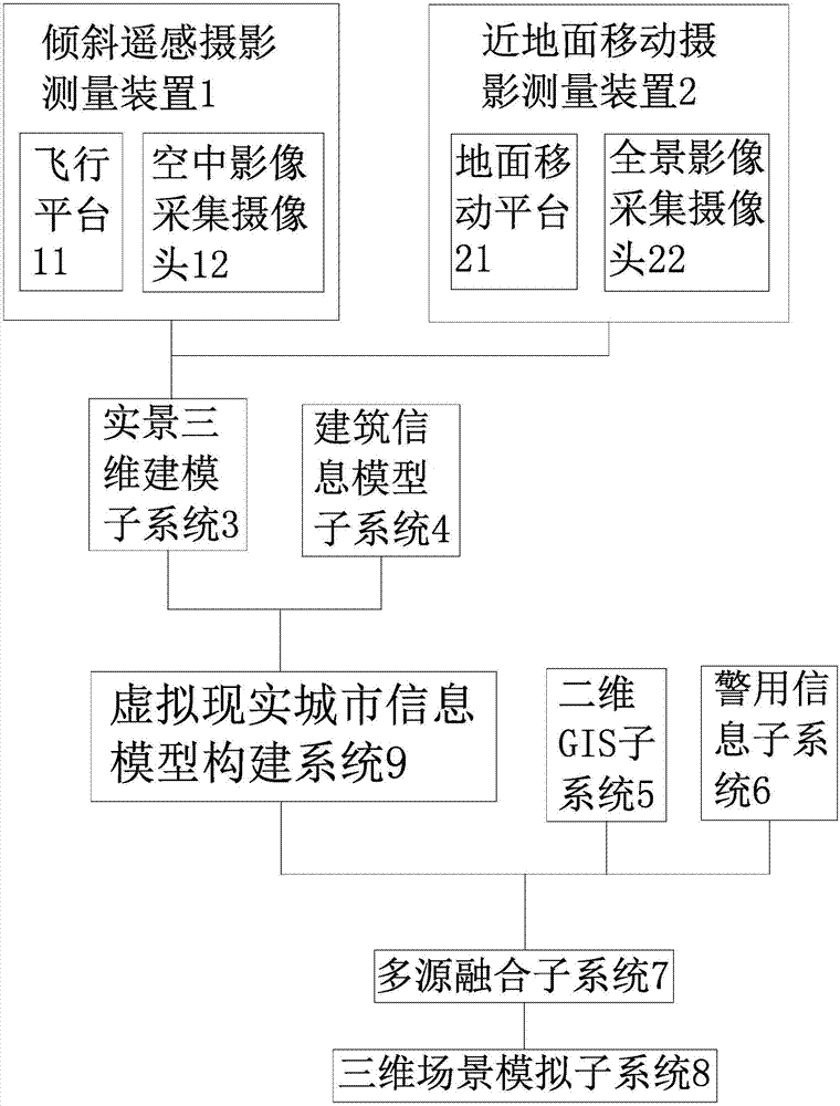
[0025] like figure 1 As shown, the multi-source image fusion imaging system of the three-dimensional police geographic information platform is characterized in that it includes: an oblique remote sensing photogrammetry device 1, a near-ground mobile photogrammetry device 2, a real-scene three-dimensional modeling subsystem 3, and a building information model Subsystem 4, two-dimensional GIS subsystem 5 and police information subsystem 6, described oblique remote sensing photogrammetry device 1 and near ground mobile photogrammetry device 2 are all connected with real scene three-dimensional modeling subsystem 3, described real scene The three-dimensional modeling subsystem 3 and the building information model subsystem 4 are all connected with the virtual reality city information model building system 9, the virtual reality city information model building system 9, the two-dimensional GIS subsystem 5 and the police information subsystem 6 All are connected with the multi-sourc...


PUM


Abstract

The invention relates to a multi-source image fusion imaging system of a three-dimensional police geographic information platform. The system solves the technical problems that an objective world simulated through the prior art is low in trueness and the like. The system comprises a tilting remote sensing photogrammeteric device, a near-surface mobile photogrammeteric device, a live-action three-dimensional modeling subsystem, a building information model subsystem, a two-dimensional GIS subsystem and a police information subsystem. The tilting remote sensing photogrammeteric device and the near-surface mobile photogrammeteric device are connected with the live-action three-dimensional modeling subsystem, the live-action three-dimensional modeling subsystem and the building information model subsystem are connected with a virtual reality city information model building system, and the city information model building system, the two-dimensional GIS subsystem and the police information subsystem are connected with a multi-source fusion subsystem. The multi-source image fusion imaging system has the advantages that technical breakthrough in uniform global positioning, air-ground integration, interior and outdoor integration, interfaces, standards and other aspects is achieved, so that multilevel police application, such as guard security, anti-terrorist, commanding and dispatching and base and grassroots, is met.

Description

technical field [0001] The invention belongs to the technical field of police information system construction, and relates to a three-dimensional geographic information platform, in particular to a multi-source image fusion imaging system of a three-dimensional police geographic information platform. Background technique [0002] At present, the application of two-dimensional police geographic information platform in various public security departments has been relatively mature. Two-dimensional GIS basically realizes various functions related to police business, such as: GIS map display function, map operation function, police map function, GPS police car display function, map query and positioning function, drawing function, etc. Although to a certain extent, it meets the needs of the daily management work of the public security department, but the two-dimensional GIS maps the three-dimensional spatial information into two-dimensional plane information, which is inevitably...

Claims


Application Information

Patent Timeline
IPC IPC(8): G06F17/30G06T17/00
CPCG06F16/29G06F16/50G06T17/00
Inventor 秦文黄瑚张军民郦兵唐恬秦华王璐璐高畅畅郑庆辉胡兵勇陈梦琳牛健荣石芳芳
Owner HANGZHOU MUNICIPAL PUBLIC SECURITY BUREAU SHANGCHENG DISTRICT BRANCH
Why Eureka
Try Eureka