Remote sensing image contrastive analysis method and system

A technology of comparative analysis of remote sensing images, applied in the field of comparative analysis of remote sensing images, can solve the problems of roughness and inaccuracy, inability to realize remote sensing images, and inability to eliminate interference of remote sensing images, and achieve high recognition rate and good fault tolerance

Active Publication Date: 2017-06-27
武汉喜恩卓科技有限责任公司
View PDF3 Cites 16 Cited by
  • Summary
  • Abstract
  • Description
  • Claims
  • Application Information

AI Technical Summary

Problems solved by technology

[0003] The technical problem to be solved by the present invention is: the traditional pixel-based comparison algorithm cannot well eliminate the interference in remo

Method used


Image

  • Remote sensing image contrastive analysis method and system
  • Remote sensing image contrastive analysis method and system
  • Remote sensing image contrastive analysis method and system

Examples


Embodiment Construction

[0033] The principles and features of the present invention are described below in conjunction with the accompanying drawings, and the examples given are only used to explain the present invention, and are not intended to limit the scope of the present invention.

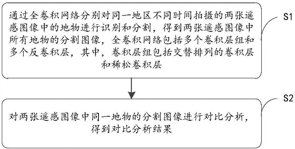
[0034] Such as figure 1 As shown, the embodiment of the present invention provides a method for comparative analysis of remote sensing images, including:

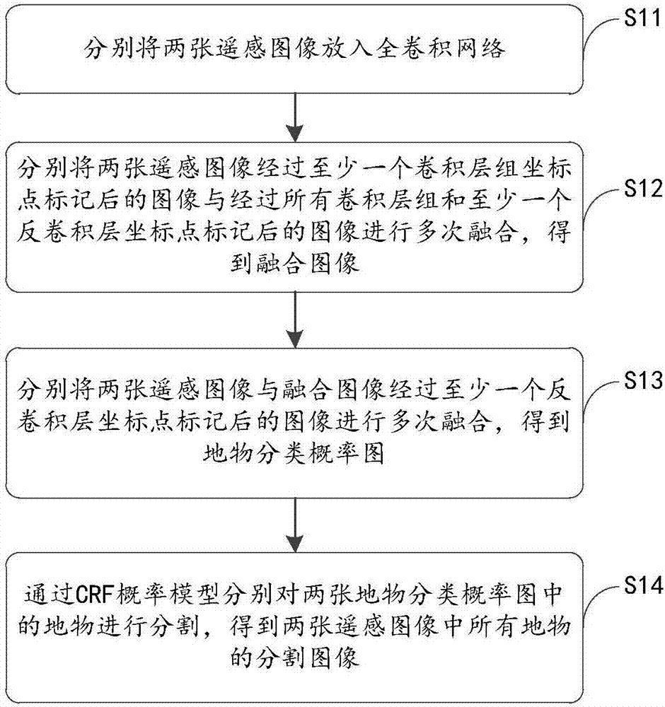
[0035] S1: Through the full convolutional network, the ground objects in the two remote sensing images taken at different times in the same area are identified and segmented, and the segmentation images of all the ground objects in the two remote sensing images are obtained. The full convolutional network includes multiple convolutions. A layer group and a plurality of deconvolution layers, wherein the convolution layer group includes alternately arranged convolution layers and sparse convolution layers;

[0036] S2: Compare and analyze the segmented images of t...


PUM


Abstract

The present invention relates to a remote sensing image contrastive analysis method and system. The method comprises: S1: carrying out identification and segmentation on surface features in two remote sensing images that are taken at different times in the same area through the full convolution network, and obtaining segmentation images of all surface features in two remote sensing images, wherein the full convolution network comprises a plurality of convolution layer groups and a plurality of deconvolution layers, and the convolution layer group comprises convolution layers and parse convolution layers that are arranged alternately; and S2: carrying out contrastive analysis on the segmentation images of the same surface feature in the two remote sensing images so as to obtain a contrastive analysis result. The beneficial effects of the method and the system disclosed by the present invention are that: the technical scheme has good fault tolerance of the interference factors such as the atmosphere, the season, and the like, and also has a relatively high identification rate of dense surface features.

Description

technical field [0001] The invention relates to the technical field of comparative analysis of remote sensing images, in particular to a method and system for comparative analysis of remote sensing images. Background technique [0002] The comparison and analysis of remote sensing images in different periods is also called change detection. It is a key technology of geographic information systems and plays a very important role in the fields of land planning, disaster prevention, drones, satellites, unmanned ships and resource monitoring. The traditional pixel-based comparison algorithm cannot eliminate the interference in the remote sensing image well, nor can it realize the classification and comparison of ground objects in the remote sensing image. The existing image comparison method is to directly compare two images, and the comparison result is rough and inaccurate. Contents of the invention [0003] The technical problem to be solved by the present invention is: th...

Claims


Application Information

Patent Timeline
IPC IPC(8): G06K9/00G06K9/34G06K9/62
CPCG06V20/13G06V10/267G06V10/751G06F18/2415
Inventor 涂刚
Owner 武汉喜恩卓科技有限责任公司
Why Eureka
Try Eureka