Ground three-dimensional laser scanning point cloud and image fusion and registration method

A three-dimensional laser and image fusion technology, applied in image enhancement, image analysis, image data processing and other directions, can solve the problems of low precision and many restrictions, achieve good fault tolerance, remove the influence of illumination changes, and enhance anti-noise. effect of ability

Inactive Publication Date: 2016-09-07
NORTHEAST FORESTRY UNIVERSITY
View PDF4 Cites 68 Cited by
  • Summary
  • Abstract
  • Description
  • Claims
  • Application Information

AI Technical Summary

Problems solved by technology

The existing fusion methods mainly focus on the extraction of common geometric features on point clouds and images, based on the principle of central projection and using collinear equations. In fact, it is still registration between 2D and 3D, with low accuracy and limitations. More conditions

Method used


Image

  • Ground three-dimensional laser scanning point cloud and image fusion and registration method
  • Ground three-dimensional laser scanning point cloud and image fusion and registration method
  • Ground three-dimensional laser scanning point cloud and image fusion and registration method

Examples


Embodiment Construction

[0041] The present invention will be described in further detail below with reference to examples.

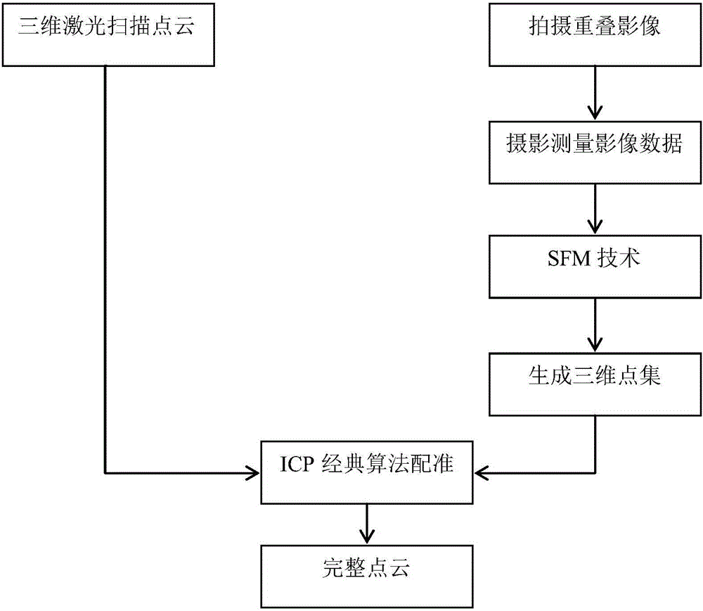
[0042] A method for fusion and registration of ground three-dimensional laser scanning point cloud and image provided by the present invention includes a point cloud and image data acquisition module, a point cloud data registration module, an image data splicing module and a dense reconstruction module; The image data acquisition module mainly collects point cloud data and image data; the iterative nearest point algorithm module mainly registers the point cloud generated by the three-dimensional laser scanning point cloud and the image three-dimensional reconstruction; the image data splicing module, It mainly uses the SIFT image stitching algorithm to stitch the collected images and photos to obtain a panoramic picture; the dense reconstruction module mainly uses the scene information and the original picture to obtain the 3D point cloud of the object in the photo;

[0043] T...


PUM


Abstract

The present invention provides a ground three-dimensional laser scanning point cloud and image fusion and registration method, and the limitation of the scanning of the ground three-dimensional laser scanning technology is overcome. The point cloud data obtained by ground three-dimensional laser scanning often comprises various areas which can not be measured, point cloud holes are generated, and thus local area information of a scanned object is lost. The holes cause that a model can not realize visualization correctly, and model subsequent processing is influenced too. For the above problems, the invention aims to solve the problems through the following technical scheme that an SIFT image is used to carry out mosaic processing of collected image photos by means of an algorithm to obtain a panoramic image, the intensive reconstruction is carried out through the panoramic image to obtain the 3D point cloud data generated by the image photo, and an iterative closest point algorithm (ICP) is used to realize the registration working of laser scanning point cloud and image data generation point cloud.

Description

technical field [0001] The invention relates to a method for registering a point cloud of three-dimensional laser scanning on the ground and a point cloud generated by three-dimensional reconstruction of an image. Background technique [0002] With the development of geospatial information technology entering a new period, the acquisition and analysis of spatial data to accurately describe three-dimensional spatial information has become the basis for the study of geospatial information. The traditional way of acquiring 3D data is not only time-consuming, but also has a low sampling density, which makes the collected data unable to accurately and completely describe the spatial objects. In addition, spatial objects and their surrounding environments are complex, and how to obtain the corresponding spatial data accurately and comprehensively has also become one of the main difficulties in current spatial information science research. The emergence of terrestrial 3D laser sca...

Claims


Application Information

Patent Timeline
Patent Type & Authority Applications(China)
IPC IPC(8): G06T7/00
CPCG06T2207/10028G06T2207/10044
Inventor 林文树李洋吴金卓
Owner NORTHEAST FORESTRY UNIVERSITY
Why Eureka
Try Eureka