Mobile-end 3D city dynamic modeling method based on geographic semantics

A dynamic modeling and mobile technology, applied in geographic information and 3D digital fields, can solve the problems of high platform hardware resource requirements, difficulty in optimization, and difficulty in supporting mobile platforms, so as to improve scene loading and rendering efficiency and reduce load. Effect

Active Publication Date: 2017-07-14
NANJING NORMAL UNIVERSITY
View PDF2 Cites 28 Cited by
  • Summary
  • Abstract
  • Description
  • Claims
  • Application Information

AI Technical Summary

Problems solved by technology

[0004] The disadvantages of the above-mentioned 3D city construction method mainly include: 1) The third-party virtual earth engine has a complex structure and many functions, and its operation efficiency is low and it is difficult to optimize
The model loading method also loads a single or multiple models into the memory at one time, which has high requirements for platform hardware resources and is difficult to support mobile platforms; 2) The modeling rules and The method is designed and encapsulated in its software, and must follow the rules and methods defined by it, which can meet...

Method used


Image

  • Mobile-end 3D city dynamic modeling method based on geographic semantics
  • Mobile-end 3D city dynamic modeling method based on geographic semantics
  • Mobile-end 3D city dynamic modeling method based on geographic semantics

Examples


Embodiment Construction

[0026] The technical solutions of the present invention will be described in detail below, but the protection scope of the present invention is not limited to the embodiments.

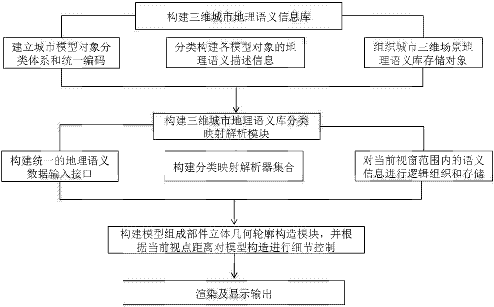
[0027] Such as figure 1 As shown, a mobile terminal three-dimensional city dynamic modeling method based on geographic semantics in this embodiment includes the following steps:

[0028] (1) Construction of 3D urban geographic semantic information database

[0029] Step 1 City Model Object Classification System and Uniform Code

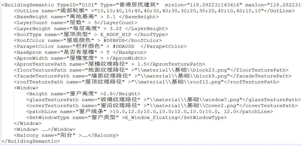
[0030] Urban model objects are divided into seven major categories: urban buildings, roads, terrain, trees, waters, bridges, and other land use types, which are coded by numbers 01 to 07 in sequence. Some large categories of city models are divided into many subcategories. The names and coding methods of the subcategories are as follows:

[0031] Urban buildings (01) are subdivided into: residential buildings (0101), public buildings (0102), industrial buildings (0103);

...


PUM


Abstract

The invention discloses a mobile-end 3D city dynamic modeling method based on geographic semantics. The method comprises the following steps: constructing classification description information and a semantic rule base of a city artificial building facility and a natural geographical entity based on a geometric semantic description method; constructing a geographic semantic library classification mapping analysis module and analyzing a semantic model stored and organized based on the geographic semantic library in a current window range; constructing a model component part 3D geometric outline construction module; and constructing a 3D model dynamic rendering and optimization display module to complete the dynamic construction and the rendering display of a 3D city. A virtual 3D city constructed on the basis of the method has flexible dynamic construction capability. The 3D scene can be constructed and generated dynamically according to a window range and an angle position in order to minimize the utilization rate of hardware resources to the utmost extent and to improve drawing efficiency for satisfying the display and render requirements of a mobile platform.

Description

technical field [0001] The present invention relates to geographical information and three-dimensional digital technology, in particular to a mobile terminal three-dimensional city dynamic modeling method based on geographic semantics. Background technique [0002] Virtual 3D city is an important content and basic supporting technology for the construction of digital cities and smart cities. Virtual 3D cities break through the limitations of traditional 2D maps, and have better display and expression capabilities for comprehensive geographic information of real cities. From the air to the Underground, from outdoor to indoor, from natural geographic entities to artificial building facilities, the virtual 3D modeling of the city is carried out in all directions and from multiple perspectives. in-depth application. [0003] At present, there are mainly three modeling methods for 3D cities at home and abroad: 1) Construct a virtual 3D city in the form of secondary development b...

Claims


Application Information

Patent Timeline
IPC IPC(8): G06T15/00G06T17/05
CPCG06T15/005G06T17/05
Inventor 彭国强李玉婷温永宁乐松山
Owner NANJING NORMAL UNIVERSITY
Why Eureka
Try Eureka