Borehole positioning method based on earth ellipse sphere

A positioning method and earth technology, applied in special data processing applications, instruments, electrical digital data processing, etc., can solve the problems of map projection deformation, error, inconvenience, etc., to eliminate errors, avoid error risks, and improve accuracy and reliability. Effect

Inactive Publication Date: 2017-07-28
CHINA PETROLEUM & CHEM CORP +1
View PDF4 Cites 7 Cited by
  • Summary
  • Abstract
  • Description
  • Claims
  • Application Information

AI Technical Summary

Problems solved by technology

However, in actual work, this coordinate system conversion problem is often ignored and calculations such as wellbore anti-collision are performed directly, resulting in inaccurate calculation results
[0007] (2) Map projection problem
[0009] (3) The curvature of the earth ellipsoid
However, due to the lack of information such as the geodetic coordinates of the borehole trajec

Method used


Image

  • Borehole positioning method based on earth ellipse sphere
  • Borehole positioning method based on earth ellipse sphere
  • Borehole positioning method based on earth ellipse sphere

Examples


Embodiment 1

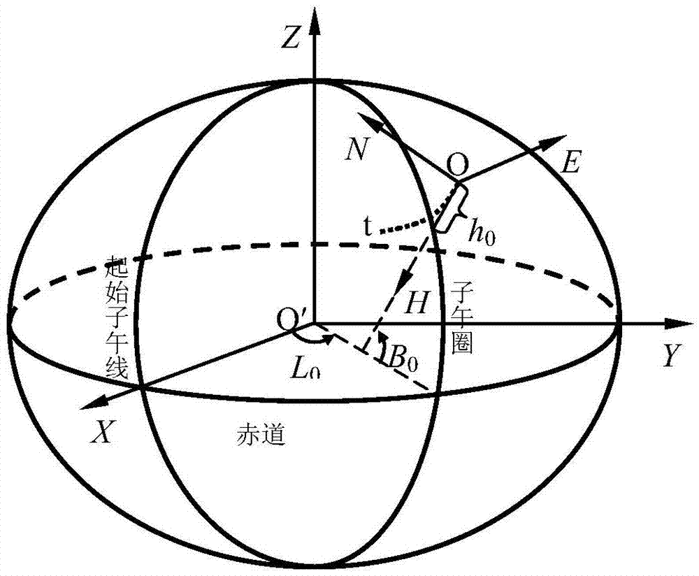
[0035] An embodiment of the present invention provides a wellbore positioning method based on an earth ellipsoid, which can be applied to the positioning of wellheads and target points of oil and gas wells. The general idea is: with the help of the geocentric Cartesian coordinate system, establish the conversion relationship between the wellhead coordinate system and the earth coordinate system, so as to obtain the spatial coordinates of the target point relative to the wellhead, and design the wellbore trajectory accordingly.

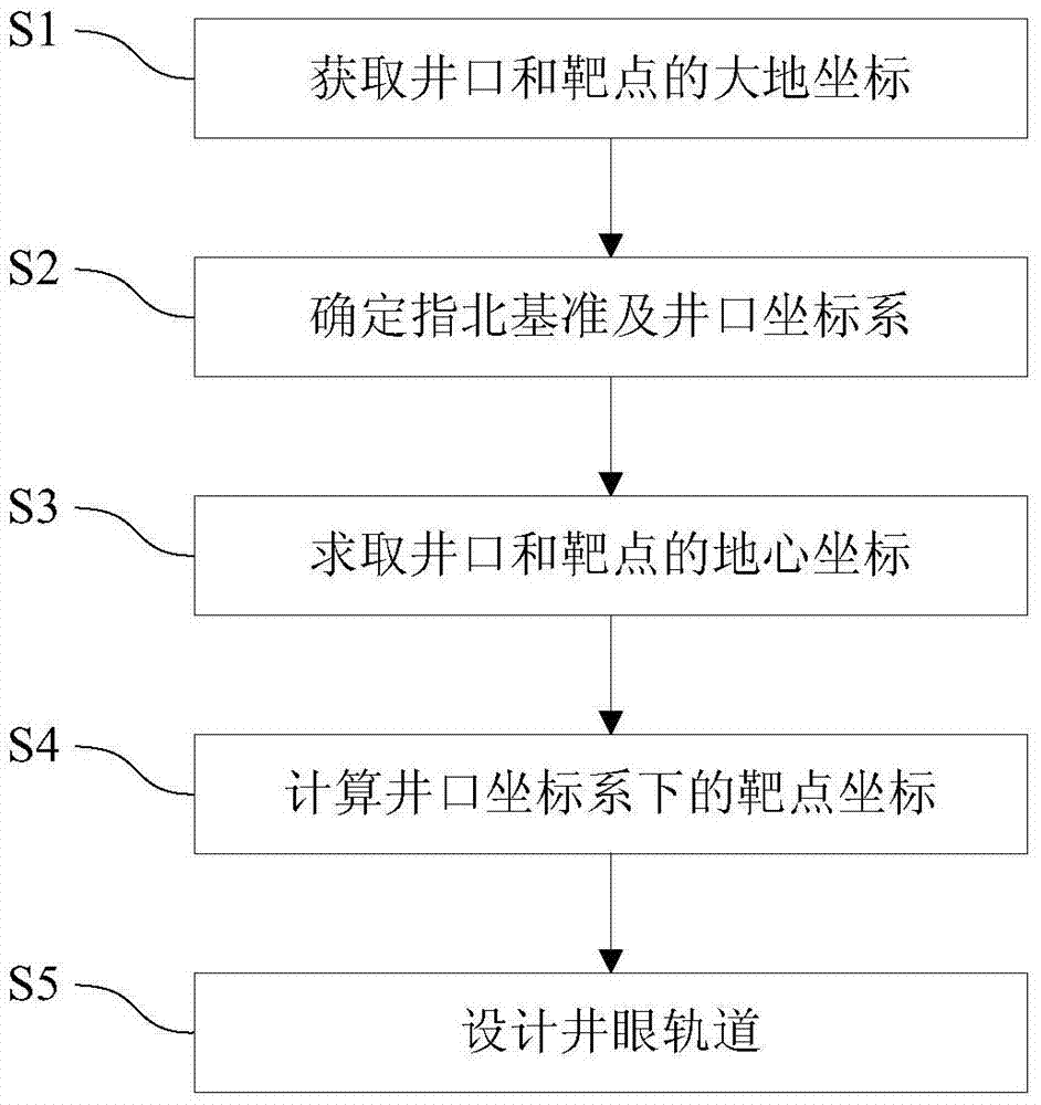
[0036] like figure 1 As shown, the borehole positioning method provided by the embodiment of the present invention mainly includes the following steps:

[0037] Step S1: Obtain the geodetic coordinates of the wellhead and the target point.

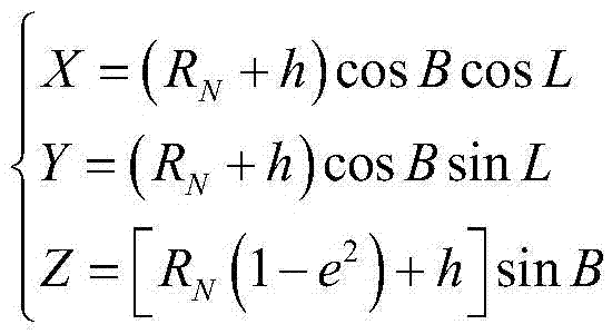
[0038] Usually, geological design provides the geodetic coordinates of the wellhead and the target point, and the geodetic coordinates include geodetic longitude L, geodetic latitude B and elevation h.

[0039] I...

Embodiment 2

[0062] This embodiment is an example of borehole positioning for a horizontal well by using the borehole positioning method provided in the above embodiments.

[0063] The geodetic coordinates of the wellhead point of the horizontal well and the two target points (target A and target B) are known data. In the 2000 national geodetic coordinate system, the map projection coordinates calculated by the Gauss-Krüger projection coordinate formula are shown in Table 1.

[0064] The geodetic coordinates and map projection coordinates of the wellhead and the target point of the present embodiment of table 1

[0065]

[0066] In the prior art, the following method is used to calculate the target point coordinates under the wellhead coordinate system: ① calculate the meridian convergence angle of the wellhead point, and the calculation result of this embodiment is -1.045°; ② subtract the wellhead from the map projection coordinates of the target point Point map projection coordinates...


PUM


Abstract

The invention discloses a borehole positioning method based on the earth ellipse sphere. The borehole positioning method comprises obtaining the geodetic coordinates of the wellhead and the target point; determining the north-seeking standard and the wellhead coordinate system; calculating the geocentric coordinates of the wellhead and the target point; calculating the target point coordinate in the wellhead coordinate system; and designing the borehole trajectory. Because the influence of the curve of the earth ellipsoid surface is considered, and map projection and projection transformation problems are not involved, errors caused by map projection deformation and concomitant various error risks are eliminated, and therefore the precision and the reliability of borehole positioning and borehole trajectory designing can be substantially improved.

Description

technical field [0001] The invention relates to the technical field of oil and gas drilling, in particular to a wellbore positioning method based on an earth ellipsoid. Background technique [0002] Drilling engineers often use the wellhead coordinate system to design, monitor and control the wellbore trajectory, while geoscientists use the geodetic coordinate system to describe the earth structure and reservoir distribution. To adapt and meet the needs of oil and gas exploration and development, the problem of wellbore positioning must be solved first. [0003] The prior art is based on the principle of map projection to locate the wellbore, and design the wellbore trajectory according to the map projection coordinates of the wellhead and the target point, and the north direction is the coordinate north of the map projection plane. Because it involves map projection and projection transformation, there are some inherent defects, mainly as follows: [0004] (1) Coordinate ...

Claims


Application Information

Patent Timeline
IPC IPC(8): G06F19/00G06Q50/02
Inventor 刘修善
Owner CHINA PETROLEUM & CHEM CORP
Why Eureka
Try Eureka