Aerial photogrammetry method based on dynamic post-processing technique of global satellite navigation system

A global satellite navigation and aerial photography technology, applied in the field of aerial photogrammetry based on global satellite navigation system dynamic post-processing technology, can solve the problem that the positioning accuracy of fixed attitude cannot meet the accuracy requirements of low-altitude photogrammetry, the price is high, the geometric size and product weight are only issues of application

Active Publication Date: 2017-08-18
SOUTHEAST UNIV
View PDF5 Cites 10 Cited by
  • Summary
  • Abstract
  • Description
  • Claims
  • Application Information

AI Technical Summary

Problems solved by technology

Not only are they expensive, but the geometry and product weight can only be applied to large UAVs
The attitude and positioning accuracy of MIMU/GNSS used in the flight navigation system of small rotor UAVs cannot meet the accuracy requirements of relevant specifications i

Method used


Image

  • Aerial photogrammetry method based on dynamic post-processing technique of global satellite navigation system
  • Aerial photogrammetry method based on dynamic post-processing technique of global satellite navigation system
  • Aerial photogrammetry method based on dynamic post-processing technique of global satellite navigation system

Examples


Embodiment Construction

[0065] The technical solution of the present invention will be described in detail below in conjunction with the accompanying drawings.

[0066] In the embodiment of the present invention, the global satellite navigation system corresponds to English: Global Navigation Satellite System, abbreviated as GNSS in the text. The dynamic post-processing technology of the global satellite navigation system, corresponding to English: GlobalNavigation Satellite System Post Processed Kinematic, abbreviated in the text: GNSS PPK.

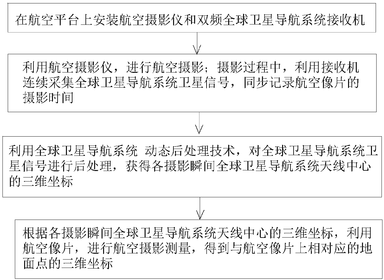
[0067] Such as figure 1 As shown, a kind of aerial photogrammetry method based on global satellite navigation system dynamic post-processing technology of the embodiment of the present invention comprises:

[0068] Step 10) An aerial camera and a dual-frequency GNSS receiver are installed on the aerial platform.

[0069] Described step 10) specifically comprises:

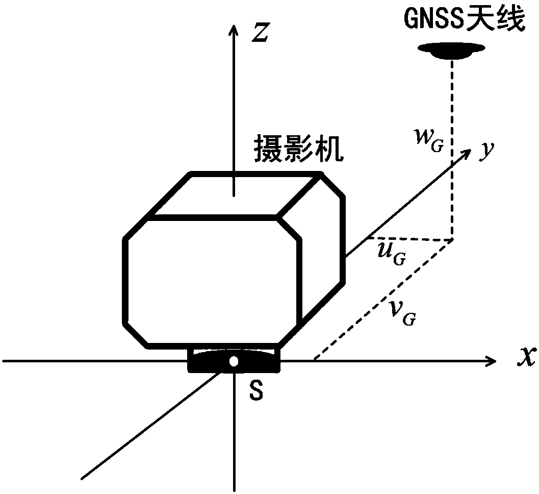
[0070] Step 101) as figure 2 As shown, the aerial photography camera and the global satellit...


PUM


Abstract

The invention discloses an aerial photogrammetry method based on a dynamic post-processing technique of a global satellite navigation system. The method comprises the following steps of: 10) mounting an aerial photographic camera and a double-frequency global satellite navigation system receiver on an aerial platform; 20) performing aerial photographing by means of the aerial photographic camera, and in the photographing process, continuously collecting satellite signals of the global satellite navigation system by means of the receiver and synchronously recording the photographing time of an aerial photograph; 30) performing post-processing on the satellite signals of the global satellite navigation system by means of the dynamic post-processing technique of the global satellite navigation system to acquire three-dimensional coordinates of an antenna center of the global satellite navigation system at photographic moments; and 40) performing aerial photogrammetry by means of the aerial photograph according to the three-dimensional coordinates of the antenna center of the global satellite navigation system at photographic moments to obtain three-dimensional coordinates of ground points corresponding to the aerial photograph. The method can perform aerial photogrammetry without ground control points by means of a GNSS PPK technique.

Description

technical field [0001] The invention belongs to the field of photogrammetry, and in particular relates to an aerial photogrammetry method based on a global satellite navigation system dynamic post-processing technology. Background technique [0002] At present, photogrammetry methods that do not require ground control points require the support of high-precision POS systems. Two commonly used high-precision IMU / DGPS systems in the world are the POS AV series products of Applanix in Canada and the AEROcontrol series products of IGI in Germany (Zhang Zuxun, Zhang Jianqing. Digital Photogrammetry. Wuhan University Press Publishing time: July 2012 2nd Edition). Not only are they expensive, but the geometry and product weight can only be applied to large drones. The attitude and positioning accuracy of MIMU / GNSS used in the flight navigation system of small rotor UAVs cannot meet the accuracy requirements of relevant specifications in low-altitude photogrammetry (General Admini...

Claims


Application Information

Patent Timeline
IPC IPC(8): G01C11/34
CPCG01C11/34
Inventor 沙月进
Owner SOUTHEAST UNIV
Why Eureka
Try Eureka