Navigation method realized by means of loose combination of visual navigation/inertial navigation
A technology of inertial navigation and visual navigation, applied in the field of navigation, can solve the problems of poor navigation accuracy, incomplete visual navigation/inertial navigation combined navigation, error accumulation over time, etc., and achieve high-precision results
- Summary
- Abstract
- Description
- Claims
- Application Information
AI Technical Summary
Problems solved by technology
Method used
Image
Examples
Embodiment Construction
[0016] The present invention will be described in detail below in conjunction with specific embodiments.
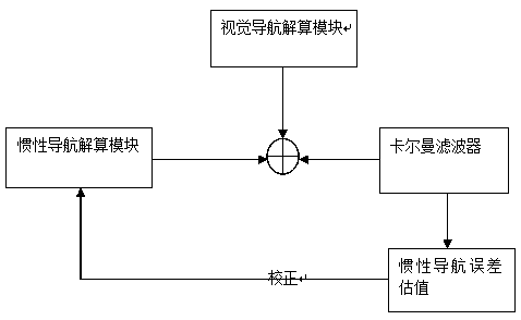
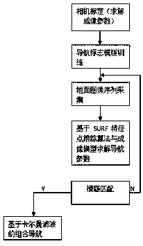
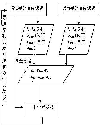
[0017] Such as figure 1 Shown, the steps of this embodiment are as follows:
[0018] Step 1, inertial navigation solution;
[0019] specifically is:
[0020] Select the local northeast sky geographic coordinate system as the navigation coordinate system, and the three-axis direction of the carrier coordinate system (system b) is "right, front, up";
[0021] (1) Initial alignment: Platform inertial navigation is the alignment between the physical platform and the navigation coordinate system; strapdown inertial navigation is the given initial attitude transformation matrix, that is, the given carrier coordinate system (b system) and navigation coordinate system (n department) relationship.
[0022] (2) Attitude update: According to the angular rate sensitive to the gyroscope, use the quaternion method for attitude update, and then convert the updated quaternion into an...
PUM
 Abstract
Description
Claims
Application Information
 - R&D
- Intellectual Property
- Life Sciences
- Materials
- Tech Scout
- Unparalleled Data Quality
- Higher Quality Content
- 60% Fewer Hallucinations
Browse by: Latest US Patents, China's latest patents, Technical Efficacy Thesaurus, Application Domain, Technology Topic, Popular Technical Reports.
© 2025 PatSnap. All rights reserved.Legal|Privacy policy|Modern Slavery Act Transparency Statement|Sitemap|About US| Contact US: help@patsnap.com


