Beidou-based emergency helicopter navigation positioning system and navigation positioning method thereof

A navigation and positioning, helicopter technology, applied in satellite radio beacon positioning system, radio wave measurement system, medical science, etc., can solve the problems of slow development, difficulty in meeting the needs of aviation rescue, and late start of aviation rescue, so as to achieve accurate positioning Effect

Active Publication Date: 2017-08-18
SOUTHEAST UNIV
View PDF3 Cites 11 Cited by
  • Summary
  • Abstract
  • Description
  • Claims
  • Application Information

AI Technical Summary

Problems solved by technology

However, my country's aviation rescue started late and developed slowly,

Method used


Image

  • Beidou-based emergency helicopter navigation positioning system and navigation positioning method thereof
  • Beidou-based emergency helicopter navigation positioning system and navigation positioning method thereof
  • Beidou-based emergency helicopter navigation positioning system and navigation positioning method thereof

Examples


Embodiment Construction

[0031] The technical solutions of the present invention will be described in detail below, but the protection scope of the present invention is not limited to the embodiments.

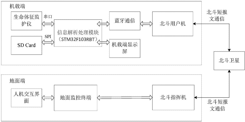
[0032] Such as figure 1 As shown, the Beidou-based emergency helicopter navigation and positioning system in this embodiment consists of two parts: the airborne end and the ground end. The airborne end includes the Beidou user machine and the airborne display screen. And man-machine interface (big screen).

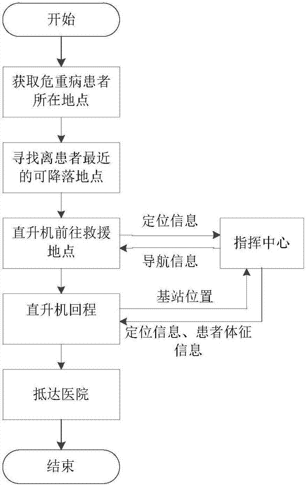
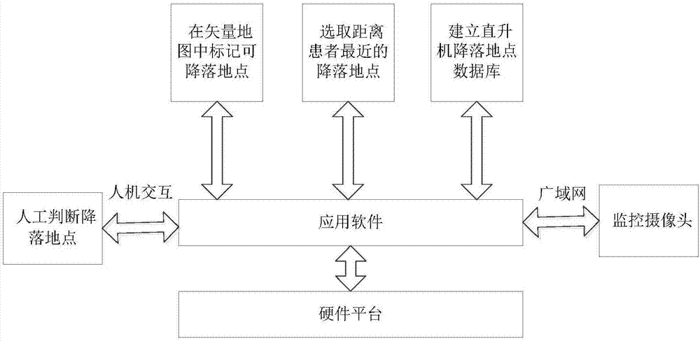
[0033] The ground monitoring terminal is responsible for integrating the helicopter positioning information and the GIS vector map information, selecting the best landing location, and completing the navigation work. The ground terminal and the airborne terminal communicate with each other through the Beidou satellite, and the ground monitoring terminal also communicates with other cross-regional cooperative users through the wide area network to instantly understand the real-time situation of the...


PUM


Abstract

The present invention discloses a Beidou-based emergency helicopter navigation positioning system and a navigation positioning method thereof. Based on the characteristics of the Beidou system, namely high-precision navigation and two-way short message communication, the landing site of an emergency helicopter can be quickly found out with the assistance of the GIS vector map technology and the image processing technology. Meanwhile, the functions of planning an optimal route, navigation, remote monitoring the life indexes of a patient and the like are realized. Based on the system and the method, the precious rescue time of gold is provided for the helicopter emergency operation on patients with critical illnesses and critically wounded patients during emergent events. Meanwhile, the conditions of patients can be known for the working personnel at hospital, so that the working personnel at hospital can prepare surgeries in advance. Therefore, the success rate of rescue is greatly improved.

Description

technical field [0001] The invention belongs to helicopter intelligent first aid technology, in particular to a Beidou-based emergency helicopter navigation and positioning system and a navigation and positioning method thereof. Background technique [0002] Aviation medical rescue was born in Germany in 1970. It is a first aid method in which doctors fly directly to patients by helicopter. Compared with traditional ambulances, medical ambulance helicopters have the advantages of being fast, efficient, highly maneuverable, and not affected by accidents such as traffic jams and road collapses. However, my country's aviation rescue started late and developed slowly, which is difficult to meet the current domestic aviation rescue needs. Due to the imperfect system and the difficulty of finding the parking place, helicopter rescue has not been popularized. How to build a complete and effective helicopter emergency intelligent system is still an urgent problem to be solved. Co...

Claims


Application Information

Patent Timeline
IPC IPC(8): G01S19/42A61B5/0205
Inventor 郭雨辰潘树国曲朝晖
Owner SOUTHEAST UNIV
Why Eureka
Try Eureka