Method and flying drone to estimate the mortality rate of trees in sparse grassland

A technology of UAV and mortality, which is applied in the field of assessing the mortality of trees in open forests and grasslands, methods and UAVs, which can solve the problems of large manpower investment, poor spatial representation of sample plots, and low application level of UAV aerial photography

Pending Publication Date: 2017-08-18
CHINESE ACAD OF FORESTRY
View PDF5 Cites 7 Cited by
  • Summary
  • Abstract
  • Description
  • Claims
  • Application Information

AI Technical Summary

Problems solved by technology

With global warming, tree death tends to increase. In addition, tree death will also affect the spatial pattern of sparse forest trees. Traditionally, the investigation of tree death and spatial pattern is mainly carried out through sampling surveys, but artificial sampling surveys Due to the disadvantages of poor environment, large manpower input, difficult working environment and low efficiency, small survey scope, and poor representativeness of sample plot space, it is impossible to carry out large-scale census.
At present, UAV technology has made great progress, but the application of UAV aerial photography in ecology and forestry is still relatively low.

Method used

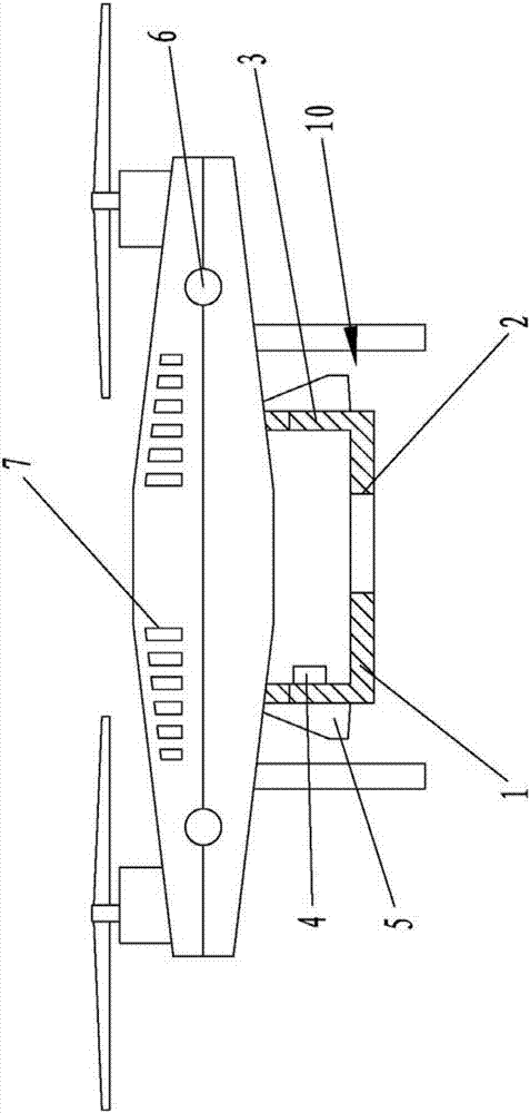

Image

  • Method and flying drone to estimate the mortality rate of trees in sparse grassland
  • Method and flying drone to estimate the mortality rate of trees in sparse grassland
  • Method and flying drone to estimate the mortality rate of trees in sparse grassland

Examples


Embodiment Construction

[0033] The method for assessing savannah grassland tree mortality of the present invention comprises:

[0034] Use the drone to shoot the target area to get the image of the target area;

[0035] counting the number of trees in the image;

[0036] identifying the number of dead trees in the image;

[0037] The tree death rate in the target area is calculated according to the number of trees in the image and the number of dead trees in the image.

[0038] In the method for assessing the mortality rate of woodland and grassland trees of the present invention, the target area is photographed by a drone, and the image of the target area is obtained including:

[0039] Set a fixed focal length digital color camera on the drone;

[0040] Determine the sensor resolution of the fixed focal length digital color camera, including:

[0041] Carry out every tree survey on the crown of the target area, that is, set several survey plots in the target area, take the trunk as the center o...


PUM


Abstract

The invention provides a method and a flying drone to estimate the morality rate of trees in sparse grassland wherein the method comprises: using a flying drone to photograph a target area; determining the number of dead trees in the photographed image; and calculating the mortality rate of trees in the target area. The flying drone of the invention comprises a camera installation base on the drone body. The bottom plate of the camera installation base is provided with a lens hole allowing the lens to be telescopic out. The side wall of the camera installation base is provided with a camera interface used to connect the camera. The camera interface is connected with a camera connection unit. A controller controls the work of the camera through the camera connection unit. With the technical schemes of the invention, it is possible to obtain the geological information such as the special distribution of trees in grassland and the mortality rate of the trees quickly, which solves the problems in manual sampling surveys that are time-consuming and not so space-representative.

Description

technical field [0001] The present invention relates to image data processing, in particular to a method and unmanned aerial vehicle for assessing tree mortality in savannah grasslands. Background technique [0002] The temperate woodland grasslands are mainly distributed in the desertification areas in northern my country, such as the Horqin Sandy Land, Hunshandake Sandy Land, and Hulunbeier Sandy Land. With global warming, tree death tends to increase. In addition, tree death will also affect the spatial pattern of sparse forest trees. Traditionally, the investigation of tree death and spatial pattern is mainly carried out through sampling surveys, but artificial sampling surveys Due to the disadvantages of poor environment, large manpower input, difficult working environment and low efficiency, small survey scope, and poor representativeness of sample plot space, it is impossible to carry out large-scale census. At present, UAV technology has achieved great development, ...

Claims


Application Information

Patent Timeline
Patent Type & Authority Applications(China)
IPC IPC(8): G06K9/00G06K9/46H04N5/232B64D47/08B64D47/00B64C27/08B64C39/02
CPCB64C27/08B64C39/02B64D47/00B64D47/08G06V20/188G06V10/44H04N23/66B64U10/10B64U2101/00B64U2101/30
Inventor 时忠杰杨晓晖刘艳书张晓葛根巴图张志永魏巍山丹潘磊磊
Owner CHINESE ACAD OF FORESTRY
Why Eureka
Try Eureka