Image splicing quality evaluation-based unmanned aerial vehicle remote sensing image splicing method

A remote sensing image and quality evaluation technology, applied in the field of image processing, can solve the problems of low stitching efficiency, heavy workload, and a large number of repetitive images, and achieve the effect of avoiding repeated collection and stitching.

Active Publication Date: 2017-09-08
GUANGXI UNIV
View PDF2 Cites 16 Cited by
  • Summary
  • Abstract
  • Description
  • Claims
  • Application Information

AI Technical Summary

Problems solved by technology

When the collected image sequence does not meet the splicing requirements or the image sequence does not completely cover the planned area, use the UAV to collect the image again along the previously planned flight trajectory, and then merge the two collected images for splicing. This results in a heavy workload, a large number of repeated images, and low stitching efficiency

Method used


Image

  • Image splicing quality evaluation-based unmanned aerial vehicle remote sensing image splicing method
  • Image splicing quality evaluation-based unmanned aerial vehicle remote sensing image splicing method

Examples


Embodiment

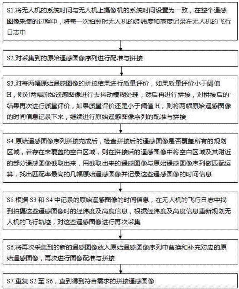
[0024] The flow chart of a method for mosaicing remote sensing images of drones based on image mosaic quality evaluation in this embodiment is as follows figure 1 shown, including the following steps:

[0025] S1. Set the system time of the UAV to be consistent with the system time of the camera on the UAV, and record the latitude, longitude and altitude of the UAV in the flight log of the UAV during the entire remote sensing image collection process middle;

[0026] Specifically, according to the parameters of the airborne camera, the angle of the lens, the flight speed and flight altitude of the UAV, the flight trajectory planning of the area to be stitched is carried out, and the flight log of the UAV is recorded throughout the process of collecting remote sensing image sequences, including flight latitude and longitude and altitude;

[0027] S2. Registering and splicing the collected original remote sensing image sequence;

[0028] Specifically, the image registration p...


PUM


Abstract

The present invention relates to the image processing technology field, in particular relates to an image splicing quality evaluation-based unmanned aerial vehicle remote sensing image splicing method. The method comprises the steps of recording the latitude and longitude information and the altitude information of an unmanned aerial vehicle when each frame of remote sensing image is acquired, using a jitter fuzzy removing algorithm to remove the jitter fuzzy of the remote sensing images, adopting the image splicing quality evaluation to find out the remote sensing images not satisfying the splicing requirements in a remote sensing image sequence, using the unmanned aerial vehicle to reacquire the remote sensing images not satisfying the requirements according to the recorded latitude and longitude information and the altitude information, putting the reacquired new remote sensing images in the original remote sensing image sequence to replace and supplement the corresponding original remote sensing images, and carrying out the image registration and splicing again, thereby avoiding the repeated acquisition and splicing of the effective images, improving the image splicing efficiency while reducing the workload.

Description

technical field [0001] The present invention relates to the technical field of image processing, and more specifically, to a method for mosaicing remote sensing images of drones based on image mosaic quality evaluation. Background technique [0002] Image stitching is the process of stitching several overlapping images into a large seamless high-resolution image, and these images may be obtained at different times, different viewing angles, or different sensors. Image stitching technology is mainly used in military, remote sensing, surveying and mapping, medicine and computer vision and other fields. With the rapid development of UAV technology, UAVs are widely used in natural disaster area assessment, resource exploration, remote sensing mapping and environmental protection with the advantages of high resolution, high flexibility, high efficiency and low cost. The registration and mosaic of UAV remote sensing images has received extensive attention, and many countries and ...

Claims


Application Information

Patent Timeline
Patent Type & Authority Applications(China)
IPC IPC(8): G06T3/40G06T5/00G06T7/33
CPCG06T3/4038G06T5/003G06T7/33G06T2207/10032
Inventor 林靖宇成耀天
Owner GUANGXI UNIV
Why Eureka
Try Eureka