Method for extracting elevation control point through assistance of satellite laser altimetry data

A technology for elevation control points and auxiliary extraction, which is applied in image data processing, measurement devices, radio wave measurement systems, etc.

Active Publication Date: 2017-09-15
CHINESE ACAD OF SURVEYING & MAPPING
View PDF6 Cites 24 Cited by
  • Summary
  • Abstract
  • Description
  • Claims
  • Application Information

AI Technical Summary

Problems solved by technology

[0008] Due to the errors in image target positioning and laser remote sensing target positioning, and the differences in remote sensing mechanisms, there is currently no effective way to achieve strict registration of the relative spatial relationship between the two.
At the same time, laser altimetry data is a comprehensive response of the target in the spot area. The elevation control point information required by remote sensing images includes image point coordinates and their corresponding elevations. The high-precision extraction of image point elevation information from laser altimetry data lacks robustness and effectiveness. method

Method used


Image

  • Method for extracting elevation control point through assistance of satellite laser altimetry data
  • Method for extracting elevation control point through assistance of satellite laser altimetry data
  • Method for extracting elevation control point through assistance of satellite laser altimetry data

Examples


Embodiment Construction

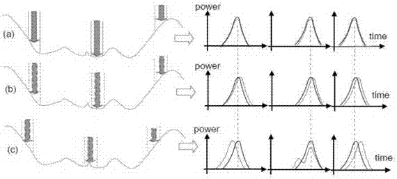
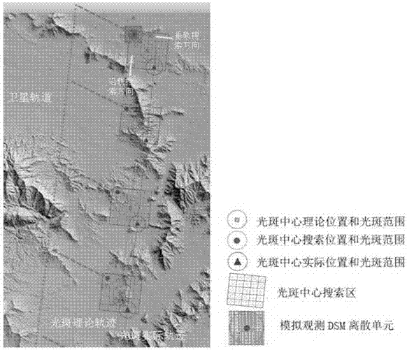
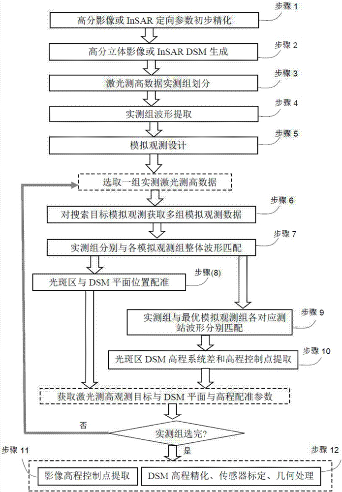
[0055]A method for extracting elevation control points assisted by satellite laser altimetry data. Using the characteristics of remote sensing target positioning system difference, the extraction of elevation control points is divided into two parts: DSM elevation and elevation system difference. Accuracy is achieved through the group matching technology of the measured waveform and the DSM simulated observation waveform in the search area, such as image 3 shown, including the following steps:

[0056] Step 1. Refinement of high-resolution stereo images or InSAR orientation parameters: Perform block adjustment or free network adjustment on high-resolution stereo images or InSAR data to obtain orientation parameters after initial refinement for use in high-resolution stereo images in subsequent steps or processing of InSAR data;

[0057] Step 2. Generate DSM from high-resolution stereoscopic images or InSAR: use orientation parameters to generate DSM with geographic coordinat...


PUM


Abstract

The invention provides a method for extracting an elevation control point through assistance of satellite laser altimetry data. The method is characterized in that an actual measurement waveform and a simulation observation waveform are taken as data processing objects; and by grouping the actual measurement waveform and the simulation observation waveform and considering the distance between two waveforms in the direction of the time axis and the similarity between the waveforms, through the combination of a remote sensing geometric model, registration of light spots and the topography and extraction of the elevation control point are achieved. The method comprises following steps of (1) initially refining a high-mark stereo image or an InSAR orientation parameter; (2) generating the high-mark stereo image or an InSAR DSM; (3) dividing actual measurement laser altimetry data groups; (4) extracting waveforms of the actual measurement groups; (5) searching targets and designing simulation observation; (6) carrying out simulation observation on the DSM to acquire the waveform of each simulation observation group; (7) matching the actual measurement group with the whole waveform of each simulation observation group; (8) carrying out registration on the light spot positions and the DSM plane positions; (9) matching the actual measurement group with corresponding waveform of each measurement station of the optimal simulation observation group; (10) extracting the DSM elevation system difference and the elevation control point of each light spot region; (11) extracting the elevation control point of an image; and (12) carrying out DSM elevation refinement, sensor calibration, laser altimetry and combined processing of image remote sensing data. According to the invention, registration of spatial targets of satellite laser altimetry data and satellite remote sensing data of different topographies, and extraction of the elevation control point can be achieved and spatial association can be established for combined processing of the satellite laser altimetry data and the remote sensing data.

Description

technical field [0001] The invention relates to the fields of high-resolution remote sensing image photogrammetry, data matching and registration, joint processing of multi-source remote sensing data, etc., and focuses on spatial matching and registration methods of laser altimetry data, DSM, and image data. Background technique [0002] Research on satellite radar altimetry technology is mainly concentrated in the United States and some developed countries in Europe, while the development of this technology in other countries, especially developing countries, is relatively lagging behind. At present, more than 10 satellite altimetry projects have been implemented in the world. The laser altimetry satellite ICESat-1 launched by the United States in 2003 carried the earth science altimetry sensor GLAS, and its orbital height is 590km. The ICESat-2 satellite planned to be launched in 2017 carried an advanced terrain laser altimeter ATLAS, using Micro-pulse multi-beam (6 laser ...

Claims


Application Information

Patent Timeline
Patent Type & Authority Applications(China)
IPC IPC(8): G01S7/48G01S17/88
CPCG01S7/4808G01S17/88G01S7/295G01S17/89G01S7/4026G01S13/865G01S13/9023G01S17/90G01S17/894G06T17/05G06T2207/10072G06T2207/10032
Inventor 程春泉左志权黄国满张继贤张力文汉江
Owner CHINESE ACAD OF SURVEYING & MAPPING
Why Eureka
Try Eureka