Method for rapidly calculating vehicle speed in area of interest of unmanned vehicle

An unmanned vehicle and region of interest technology, applied in the field of moving target detection and speed measurement based on 3D lidar, can solve the problems of real-time performance degradation and algorithm complexity increase

Pending Publication Date: 2017-09-22
SHANDONG UNIV OF TECH
View PDF5 Cites 22 Cited by
  • Summary
  • Abstract
  • Description
  • Claims
  • Application Information

AI Technical Summary

Problems solved by technology

[0004] Usually, the identification of surrounding targets in the area of ​​interest of unmanned vehicles and the calculation of the speed of moving targets rely more on the fusion of information collected by sensors such as cameras and lidars. The increase in complexity and the decrease in real-time performance, how to strike a balance between the two, and realize an algorithm with acceptable real-time performance and recognition accuracy has become a difficult point in research in this field.

Method used


Image

  • Method for rapidly calculating vehicle speed in area of interest of unmanned vehicle
  • Method for rapidly calculating vehicle speed in area of interest of unmanned vehicle
  • Method for rapidly calculating vehicle speed in area of interest of unmanned vehicle

Examples


Embodiment Construction

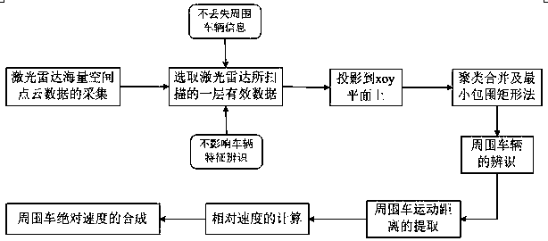
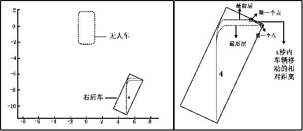
[0009] The present invention proposes a method for quickly calculating the absolute speed of surrounding vehicles in the area of ​​interest of the unmanned vehicle based on three-dimensional laser radar point cloud data, which includes: selecting a certain layer of effective data scanned by the laser radar, and projecting it onto On the xoy plane; use the method of clustering and merging and the minimum enclosing rectangle to identify the surrounding vehicles in the area of ​​interest of the unmanned vehicle; extract the movement information of the surrounding vehicles and calculate their absolute speed. The complete technical process such as figure 1 As shown, the details are as follows:

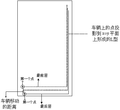
[0010] Step 1. According to the massive point cloud information scanned by the 3D lidar, select the scanned data of a certain layer (a certain height range) and project it onto the xoy plane.

[0011] The multi-line lidar is installed on the roof of the driverless car, which can collect th...


PUM


Abstract

The reliable perceptual data source can be provided for environmental perception of an unmanned vehicle by three-dimensional laser radar. The invention discloses a method for calculating absolute speed of surrounding vehicles in the area of interest of the unmanned vehicle in real time based on the three-dimensional laser radar. The method comprises the steps that the massive space point cloud data of the surrounding environment of the unmanned vehicle are acquired by using the three-dimensional laser radar; a certain layer of point cloud data representing the vehicle characteristics are extracted in a way of being adaptive to the distance and projected to an xoy plane; the moving vehicles in the area of interest of the unmanned vehicle are identified by applying the cluster merging and minimum bounding rectangle method; the relative speed of the surrounding vehicles is calculated by using distance information of the first point projected to the foremost layer and the last layer of the xoy plane in relative motion between the vehicles; and the speed is synthesized with the speed of the unmanned vehicle so as to obtain the absolute speed of the surrounding vehicles. The method is simple and reliable in algorithm and high in timeliness so that the basis can be provided for route planning and tracking and lane changing and other driving strategy of the unmanned vehicle on the road.

Description

technical field [0001] The invention relates to the field of environment perception of unmanned vehicles, in particular to a method for detecting and measuring a moving target based on a three-dimensional laser radar. Background technique [0002] The unmanned vehicle system generally uses a combination of various sensors to realize the data collection of the surrounding environment of the vehicle, obtains road environment information through multi-source information fusion, and then processes the obtained data to obtain the location of the vehicle and surrounding obstacles , distance and speed information, and then provide a basis for path planning and various control decisions. [0003] Environmental perception is a relatively basic and critical link in the entire unmanned vehicle system. The perceived environmental information is mainly the driving road environment, and the detection of moving obstacles is particularly critical. According to different data sources, movin...

Claims


Application Information

Patent Timeline
Patent Type & Authority Applications(China)
IPC IPC(8): G01S17/58G01S17/93
CPCG01S17/58G01S17/931
Inventor 王晓原王方谭德荣高松孙亮邵金菊孔栋孙一帆刘丽萍
Owner SHANDONG UNIV OF TECH
Why Eureka
Try Eureka