Method for rapidly converting spherical triangle discretization grid codes into geographic longitude and latitude coordinates

A technology of spherical triangles and geographic latitude and longitude, applied in the field of geographic information systems, can solve problems such as low efficiency

Active Publication Date: 2017-10-20
NANJING NORMAL UNIVERSITY
View PDF4 Cites 6 Cited by
  • Summary
  • Abstract
  • Description
  • Claims
  • Application Information

AI Technical Summary

Problems solved by technology

If it is possible to find a suitable control subdivision level as the threshold according to the change law of the geometric properties of the grid, use a recursive approximation conversion method that can ensure accuracy but low efficiency in the subdivision level below the threshold, and

Method used


Image

  • Method for rapidly converting spherical triangle discretization grid codes into geographic longitude and latitude coordinates
  • Method for rapidly converting spherical triangle discretization grid codes into geographic longitude and latitude coordinates
  • Method for rapidly converting spherical triangle discretization grid codes into geographic longitude and latitude coordinates

Examples


Embodiment 1

[0050] In this embodiment, take the SQC coding of the 22-layer cell of the regular icosahedral triangular discrete grid where the School of Geographical Sciences of Nanjing Normal University Xianlin Campus is located as an example, use the algorithm of the present invention to convert it into geographic coordinates, and the SQC coding is (110111010101101000010100100101011001111000000).

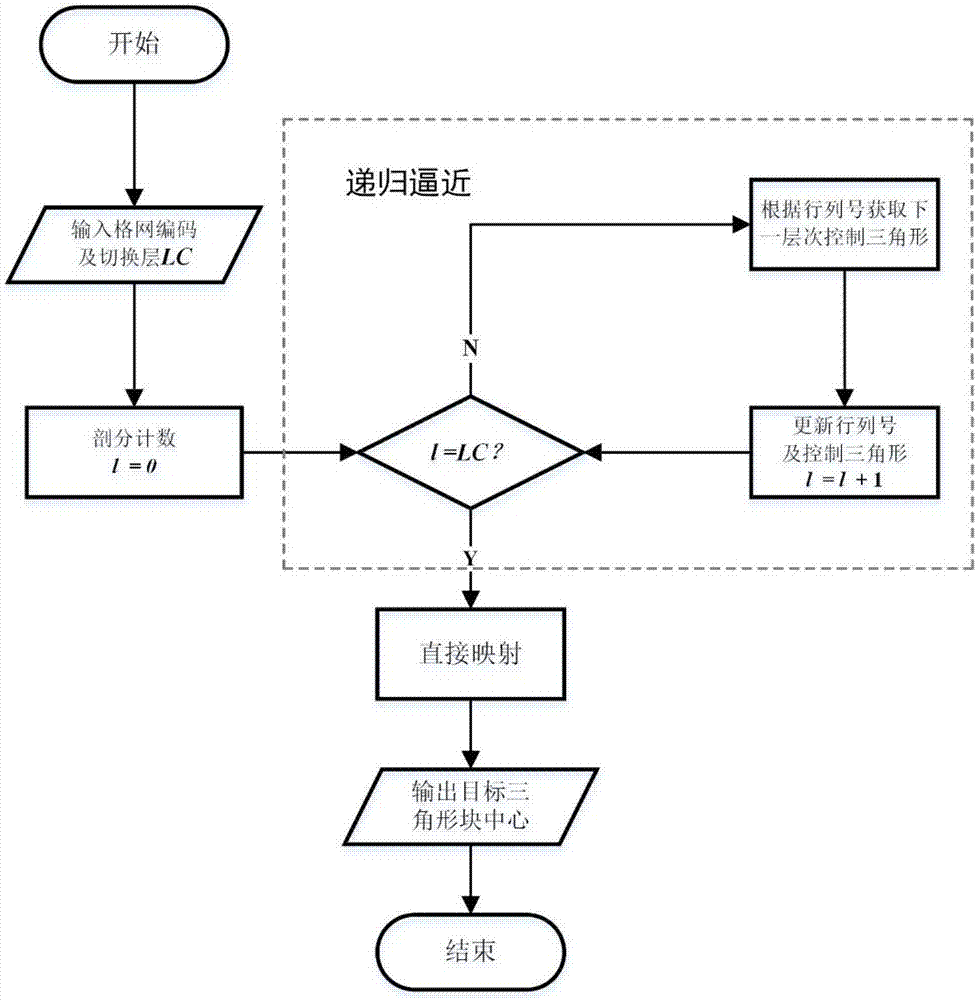
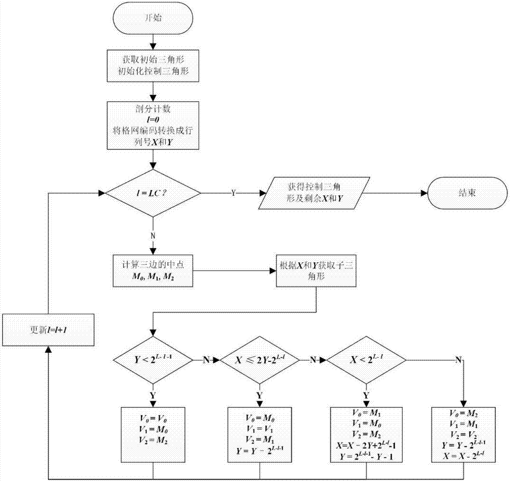
[0051] The conversion process of this embodiment is divided into two important parts, the recursive approximation before the control subdivision level and the direct mapping after the control subdivision level.

[0052] 1. The steps of the recursive approximation process are as follows:

[0053] Step 1: Obtain the initial triangle unit corresponding to number 2 according to the grid code, and use its vertices to initialize the control triangle V 0 V 1 V 2 ;

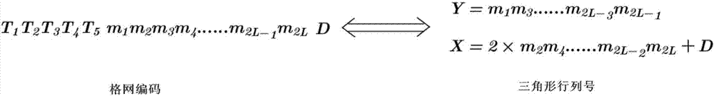
[0054] Step 2: Initialize grid division count l=0, such as figure 2 As shown, the corresponding relationship between SQC coding an...


PUM


Abstract

The invention discloses a method for rapidly converting spherical triangle discretization grid codes into geographic longitude and latitude coordinates. The method comprises the following steps of inputting grid codes, and converting the grid codes into rank numbers; according to dissection layers of the codes, determining a control dissection layer; in a stage lower than the control dissection layer, adopting a recursive approaching method for determining a control triangular unit corresponding to the grid codes on the control dissection layer and the rank number of the target code cell inside the control triangle; when the control dissection layer is converted, adopting a direct mapping method for directly dividing the control triangle into grids in a halving mode, and then finding a target triangular cell according to the rank number inside the control triangle; calculating coordinates of the central point of the target triangular cell, converting the rectangular coordinates into longitude and latitude coordinates, and outputting the coordinates to complete conversion. The efficiency of converting spherical triangle discretization grid codes into geographic longitude and latitude coordinates can be obviously improved, and the algorithm time complexity is increased along with the dissection layers and increased linearly.

Description

technical field [0001] The invention relates to geographic information system technology, in particular to a method for quickly converting spherical triangular discrete grid codes to geographic longitude and latitude coordinates. Background technique [0002] Spherical triangle discrete grid is a classic global discrete grid system. It takes the triangle as the basic grid unit, and performs isomorphic discretization on the spherical space based on the regular octahedron or icosahedron to form a multi-scale global grid system with hierarchical recursion, uniform unit shape, seamless and non-overlapping ( Tong, 2013). After long-term research by many scholars, the spherical triangular discrete grid has not only become an effective tool for global multi-resolution spatial data modeling, but also widely used in spatial data indexing and visualization (Goodchild, 1992; Feket, 1990), map synthesis model (Dutton, 1996), global navigation model (Lee, 2000), global environmental mo...

Claims


Application Information

Patent Timeline
IPC IPC(8): G06F17/30
CPCG06F16/29
Inventor 周良辰许德朋练文杰林冰仙闾国年
Owner NANJING NORMAL UNIVERSITY
Why Eureka
Try Eureka