The Antenna Layout Method for Remote Sensing Satellite Navigation Suitable for Bilateral Viewing

A technology of remote sensing satellite and layout method, which is applied in the direction of instrumentation, design optimization/simulation, calculation, etc., to achieve the effect of improving positioning speed measurement accuracy and reducing measurement error

Active Publication Date: 2020-07-14
SHANGHAI SATELLITE ENG INST
View PDF3 Cites 0 Cited by
  • Summary
  • Abstract
  • Description
  • Claims
  • Application Information

AI Technical Summary

Problems solved by technology

[0004] The technical problem to be solved by the present invention is to provide a navigation antenna layout method suitable for double-sided viewing remote sensing satellites, which solves the problem of the navigation antenna layout of a certain double-sided viewing remote sensing satellite. The effective field of view and the number of navigation satellites that can be captured in orbit can improve the positioning and speed measurement accuracy of satellites in orbit, reduce the measurement error of satellite orbits, and lay a solid foundation for high-resolution imaging of payload antennas

Method used


Image

  • The Antenna Layout Method for Remote Sensing Satellite Navigation Suitable for Bilateral Viewing

Examples


Embodiment Construction

[0015] The preferred embodiments of the present invention are given below in conjunction with the accompanying drawings to describe the technical solution of the present invention in detail.

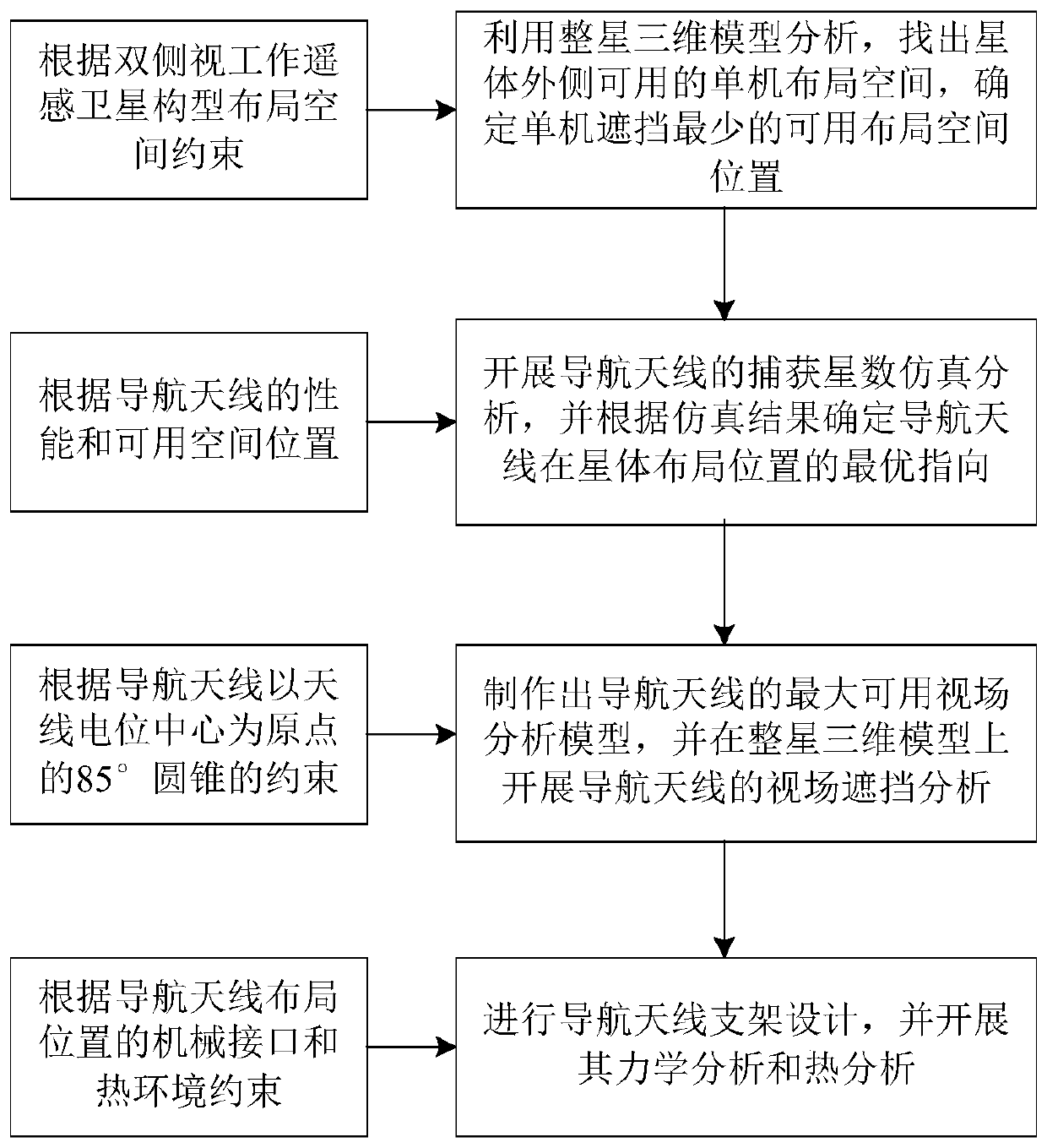
[0016] Such as figure 1 As shown, the present invention is suitable for double-sided viewing remote sensing satellite navigation antenna layout method comprising the following steps:

[0017] Step 1. According to the spatial constraints of the configuration and layout space of the dual-view remote sensing satellite, use the three-dimensional model analysis of the whole star to find out the available stand-alone layout space outside the star, and determine the available layout space position with the least blockage of the stand-alone;

[0018] Step 2, according to the performance of the navigation antenna and the available space position, carry out the simulation analysis of the number of captured stars of the navigation antenna, and determine the optimal pointing of the navigation antenn...


PUM


Abstract

The invention discloses a navigation antenna layout method suitable for a dual-side-looking work remote sensing satellite. The method includes the following steps that 1, according to the configuration layout space constraint of the dual-side-looking work remote sensing satellite, by means of whole satellite three-dimensional model analysis, available single-machine layout space on the outer side of a satellite body is found, and the position of the available layout space least shielded by a single machine is determined; 2, capture satellite number simulation analysis of navigation antennas is developed according to the performance of the navigation antennas and the available space position, and the optimal direction of the navigation antennas in satellite body layout positions is determined according to the simulation result. The problem about the navigation antenna layout of the dual-side-looking work remote sensing satellite is solved, the number of the navigation satellites can be captured by increasing available effective view fields and in-orbits of the navigation antennas in a common work mode, therefore, the positioning and speed measuring precision of the satellite in-orbits is improved, measuring errors of satellite in-orbit running rails are reduced, and a solid foundation is laid for high-definition imaging of load antennas.

Description

technical field [0001] The invention relates to the technical field of satellite overall design, in particular to a layout method for remote sensing satellite navigation antennas suitable for double-side-view work. Background technique [0002] With the rapid development of satellite technology, improving the quality of high-resolution imaging has become an urgent problem for satellite models. Remote sensing satellite imaging needs to eliminate the influence of orbit measurement errors. Generally, satellites fly in orbit in a side-view working mode, and the imaging resolution The rate is relatively low. At this time, the use of ground or on-board measurement methods can solve the influence of satellite orbit measurement errors. For the impact on positioning, ground imaging processing directly uses high-precision navigation orbit measurement data. The accuracy of navigation orbit measurement data largely depends on the effective field of view of the navigation antenna and th...

Claims


Application Information

Patent Timeline
Patent Type & Authority Patents(China)
IPC IPC(8): G06F30/20G06F119/08G06F119/14
CPCG06F30/20G06F2119/06G06F2119/08
Inventor 王晓锋于广洋崔相臣李彪任伟徐沈鑫
Owner SHANGHAI SATELLITE ENG INST
Why Eureka
Try Eureka