Method for determining satellite differential pseudo-range deviation based on single-frequency navigation satellite data

A satellite differential and data determination technology, which is applied to satellite radio beacon positioning systems, measuring devices, instruments, etc., can solve the problems of high cost, low cost, and low efficiency, and achieve low cost, reduced input cost, and high efficiency. Effect

Active Publication Date: 2017-11-17
INST OF GEODESY & GEOPHYSICS CHINESE ACADEMY OF SCI
View PDF3 Cites 37 Cited by
  • Summary
  • Abstract
  • Description
  • Claims
  • Application Information

AI Technical Summary

Problems solved by technology

[0003] The purpose of the present invention is to overcome the defects and problems of high cost and low efficiency in the prior art, and provide a me

Method used


Image

  • Method for determining satellite differential pseudo-range deviation based on single-frequency navigation satellite data
  • Method for determining satellite differential pseudo-range deviation based on single-frequency navigation satellite data
  • Method for determining satellite differential pseudo-range deviation based on single-frequency navigation satellite data

Examples


Embodiment

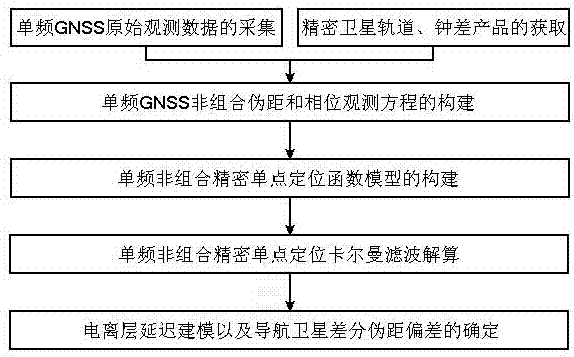
[0092] see figure 1 , a method for determining satellite differential pseudorange deviation based on single-frequency navigation satellite data, the method includes the following steps:

[0093] A. Collection of single-frequency GNSS raw observation data and acquisition of precise satellite orbit and clock error products

[0094] The current market price of UBLOX EVK-M8T receiver is only 249 US dollars, which can simultaneously capture the ranging signals of three navigation systems modulated on their first frequency, and the maximum number of tracking satellites is 25, using the single-frequency GNSS receiver EVK –M8T is used as a hardware platform to collect single-frequency observation data of navigation satellites, and the sampling rate is 30s; the precision satellite orbit and clock error products adopt the multi-GNSS precision satellite products provided by the international GNSS service organization IGS website;

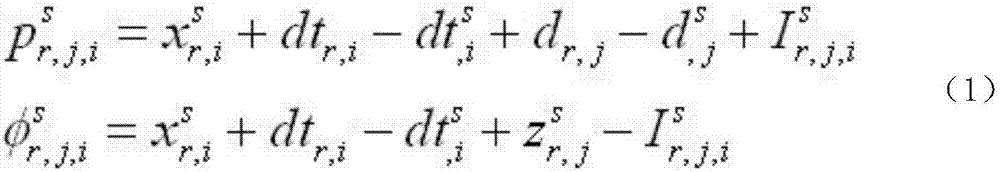
[0095] B. Construction of single-frequency GNSS non-com...


PUM


Abstract

The invention discloses a method for determining the satellite differentia pseudo-range deviation based on single-frequency navigation satellite data, and relates to a satellite differential pseudo-range deviation determination and correction technology in satellite navigation applications. The method comprises the steps of A, acquiring single-frequency GNSS original observation data and obtaining precision satellite orbit and clock error products; B, building single-frequency GNSS non-combination pseudo-range and phase observation equations; C, building a single-frequency non-combination precision single-point positioning function model; D, solving single-frequency non-combination precision single-point positioning Kalman filtering; and E, performing ionospheric delay modeling and determining the navigation satellite differential pseudo-range deviation. Determination for navigation satellite differential pseudo-range deviation parameters is realized by using a single-frequency receiver, and the hardware cost of an existing navigation satellite differential pseudo-range deviation estimation method can be reduced by more than 90%. Meanwhile, the method is reasonable and simple in design and improves the efficiency. The design is not only low in cost, but also high in efficiency.

Description

technical field [0001] The invention relates to satellite differential pseudo-range deviation determination and correction technology in satellite navigation applications, in particular to a method for determining satellite differential pseudo-range deviation based on single-frequency navigation satellite data, which is mainly suitable for reducing costs and improving efficiency. Background technique [0002] Satellite differential pseudorange bias (DCB) is the delay deviation of global satellite navigation system (GNSS) ranging signals in satellite hardware channels. This parameter is a systematic error that seriously affects the accuracy of GNSS ionospheric monitoring and modeling. At the same time, it is also a It is one of the errors that must be eliminated in the comprehensive processing of multi-frequency GNSS observation data. There are two ways to determine the DCB parameters of navigation satellites: hardware calibration method and software estimation method. Naviga...

Claims


Application Information

Patent Timeline
IPC IPC(8): G01S19/37G01S19/42
CPCG01S19/37G01S19/42
Inventor 袁运斌张红星张宝成李敏张啸
Owner INST OF GEODESY & GEOPHYSICS CHINESE ACADEMY OF SCI
Why Eureka
Try Eureka